1036 Victoria Rd Wando, SC 29492
Wando NeighborhoodEstimated payment $5,761/month
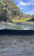
About This Lot
Prime Location ready for development at St. Thomas Island. Just 1 minute from I-526 at Clements Ferry Rd, approximately 135 feet of road frontage, just before the well-established subdivision, Shell Ring at St. Thomas Island. Endless possibilities! ZONING CODE: R1-MM
Property Details
Property Type
- Land
Est. Annual Taxes
- $5,848
Lot Details
- 3.27 Acre Lot
Schools
- Daniel Island Elementary And Middle School
- Philip Simmons High School
Community Details
- St. Thomas Island Subdivision
Map
Home Values in the Area
Average Home Value in this Area
Tax History
| Year | Tax Paid | Tax Assessment Tax Assessment Total Assessment is a certain percentage of the fair market value that is determined by local assessors to be the total taxable value of land and additions on the property. | Land | Improvement |
|---|---|---|---|---|
| 2024 | $5,848 | $25,086 | $25,086 | $0 |
| 2023 | $5,848 | $25,086 | $25,086 | $0 |
| 2022 | $5,886 | $22,812 | $22,812 | $0 |
| 2021 | $2,173 | $8,330 | $8,328 | $0 |
| 2020 | $2,182 | $8,328 | $8,328 | $0 |
| 2019 | $2,177 | $8,328 | $8,328 | $0 |
| 2018 | $2,008 | $7,242 | $7,242 | $0 |
| 2017 | $2,008 | $7,242 | $7,242 | $0 |
| 2016 | $2,028 | $7,240 | $7,240 | $0 |
| 2015 | $1,926 | $7,240 | $7,240 | $0 |
| 2014 | $1,797 | $7,240 | $7,240 | $0 |
| 2013 | -- | $7,240 | $7,240 | $0 |
Property History
| Date | Event | Price | Change | Sq Ft Price |
|---|---|---|---|---|
| 04/07/2025 04/07/25 | Price Changed | $955,000 | -4.4% | -- |
| 01/16/2025 01/16/25 | Price Changed | $999,000 | -20.1% | -- |
| 08/26/2024 08/26/24 | For Sale | $1,250,000 | -- | -- |
Purchase History
| Date | Type | Sale Price | Title Company |
|---|---|---|---|
| Quit Claim Deed | -- | Weeks & Irvine Llc | |
| Deed | $362,500 | Weeks & Irvine Llc | |
| Legal Action Court Order | $5,000 | -- |
Mortgage History
| Date | Status | Loan Amount | Loan Type |
|---|---|---|---|
| Previous Owner | $126,658 | Unknown |
Source: CHS Regional MLS
MLS Number: 24021517
APN: 275-00-00-187
Disclaimer: Certain information contained herein is derived from information provided by parties other than Homes.com. All information provided is deemed reliable, but is not guaranteed to be accurate and should be independently verified.
![]() The information is being provided by Charleston Trident MLS. Information deemed reliable but not guaranteed. Information is provided for consumers' personal, non-commercial use, and may not be used for any purpose other than the identification of potential properties for purchase. © 2025 Charleston Trident MLS. All Rights Reserved
The information is being provided by Charleston Trident MLS. Information deemed reliable but not guaranteed. Information is provided for consumers' personal, non-commercial use, and may not be used for any purpose other than the identification of potential properties for purchase. © 2025 Charleston Trident MLS. All Rights Reserved
- 327 Megans Bay Ln
- 0 Saint Thomas Island Dr
- 104 Antilles Cir
- 524 Amalie Farms Dr
- 00 Clements Ferry Rd
- 0 Harvest Time Place
- 138 Sandshell Dr
- 1088 Saint Thomas Island Dr
- 120 Andrew Ln
- 840 Forrest Dr
- 779 Forrest Dr
- 178 Beresford Creek St
- 0 Pinefield Rd Unit 23016301
- 117 Lucia St
- 228 Beresford Creek St
- 205 Fairchild St
- 11 Dalton St
- 193 Corn Planters St
- 339 Laurens View Ln
- 331 Laurens View Ln
- 524 Amalie Farms Dr
- 716 Oyster Isle Dr
- 788 Oyster Isle Dr
- 405 Intertidal Dr
- 350 Henslow Dr
- 161 Grande Oaks Dr
- 480 Seven Farms Dr
- 455 Seven Farms Dr
- 600 Bucksley Ln Unit 205
- 7770 Farr St
- 900 Corby Ln
- 650 Enterprise Blvd Unit Field Pea
- 650 Enterprise Blvd Unit Kale
- 650 Enterprise Blvd Unit Rosemary
- 650 Enterprise Blvd
- 50 Central Island St
- 1071 Barfield St
- 515 Robert Daniel Dr
- 211 River Landing Dr Unit Alexander
- 211 River Landing Dr Unit Hertiage
