Estimated Value: $216,000 - $254,000
3
Beds
2
Baths
1,600
Sq Ft
$143/Sq Ft
Est. Value
About This Home
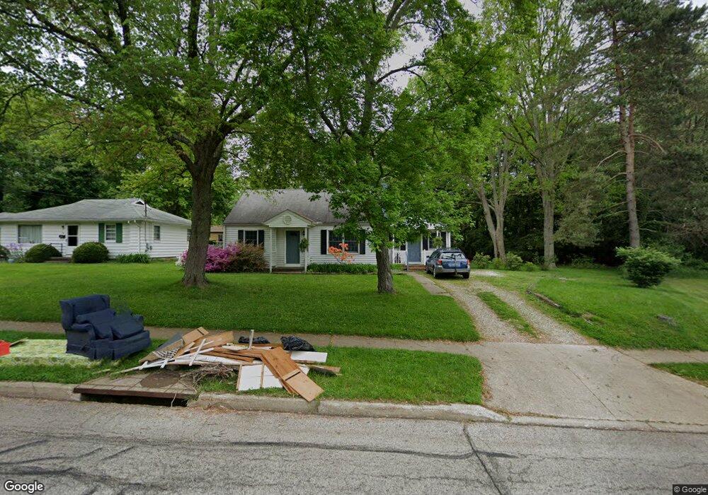
This home is located at 1103 Elno Ave, Kent, OH 44240 and is currently estimated at $228,340, approximately $142 per square foot. 1103 Elno Ave is a home located in Portage County with nearby schools including Longcoy Elementary School, Stanton Middle School, and Theodore Roosevelt High School.
Ownership History
Date
Name
Owned For
Owner Type
Purchase Details
Closed on
Feb 4, 2020
Sold by
Craven Veronica V M and Vaught Christina
Bought by
Vaught Eric P
Current Estimated Value
Home Financials for this Owner
Home Financials are based on the most recent Mortgage that was taken out on this home.
Original Mortgage
$73,000
Outstanding Balance
$64,807
Interest Rate
3.74%
Mortgage Type
Future Advance Clause Open End Mortgage
Estimated Equity
$163,533
Purchase Details
Closed on
Sep 12, 2019
Sold by
Estate Of Paul E Craven
Bought by
Craven Veronica V M
Purchase Details
Closed on
Jan 1, 1990
Bought by
Craven Paul E
Create a Home Valuation Report for This Property
The Home Valuation Report is an in-depth analysis detailing your home's value as well as a comparison with similar homes in the area
Home Values in the Area
Average Home Value in this Area
Purchase History
| Date | Buyer | Sale Price | Title Company |
|---|---|---|---|
| Vaught Eric P | $82,500 | Buckeye Reserve Title Agency | |
| Craven Veronica V M | -- | None Available | |
| Craven Paul E | -- | -- |
Source: Public Records
Mortgage History
| Date | Status | Borrower | Loan Amount |
|---|---|---|---|
| Open | Vaught Eric P | $73,000 |
Source: Public Records
Tax History Compared to Growth
Tax History
| Year | Tax Paid | Tax Assessment Tax Assessment Total Assessment is a certain percentage of the fair market value that is determined by local assessors to be the total taxable value of land and additions on the property. | Land | Improvement |
|---|---|---|---|---|
| 2024 | $2,601 | $58,030 | $12,320 | $45,710 |
| 2023 | $2,823 | $50,720 | $12,320 | $38,400 |
| 2022 | $2,832 | $50,720 | $12,320 | $38,400 |
| 2021 | $2,873 | $50,720 | $12,320 | $38,400 |
| 2020 | $2,776 | $42,560 | $12,320 | $30,240 |
| 2019 | $2,110 | $42,560 | $12,320 | $30,240 |
| 2018 | $1,999 | $38,610 | $13,620 | $24,990 |
| 2017 | $1,999 | $38,610 | $13,620 | $24,990 |
| 2016 | $1,994 | $38,610 | $13,620 | $24,990 |
| 2015 | $1,995 | $38,610 | $13,620 | $24,990 |
| 2014 | $2,028 | $38,610 | $13,620 | $24,990 |
| 2013 | $2,013 | $38,610 | $13,620 | $24,990 |
Source: Public Records
Map
Nearby Homes
- 1181 Norwood St
- 1265 W Main St
- 458 Sunrise Dr
- 3127 Deercrest Path
- 600 Silver Meadows Blvd
- 2973 Mourning Dove Cir
- 420 Dodge St
- 346 Harris St
- 3314 Charles Place
- 328 Dodge St
- 978 Silver Meadows Blvd
- 1204 Franklin Ave
- 115 S Mantua St
- 715 Franklin Ave
- 146 W Elm St
- 634 S Water St
- 4363 Ohio 43
- 529 Rockwell St
- 646 S Depeyster St
- 334 N Mantua St