120 Andrew Ln Charleston, SC 29492
Wando NeighborhoodEstimated payment $4,327/month
Highlights
- 3.4 Acre Lot
- Wetlands on Lot
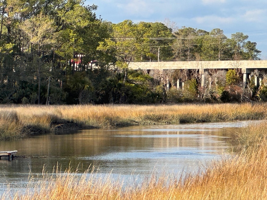
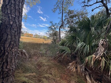
- Property fronts a marsh
- Daniel Island School Rated A-
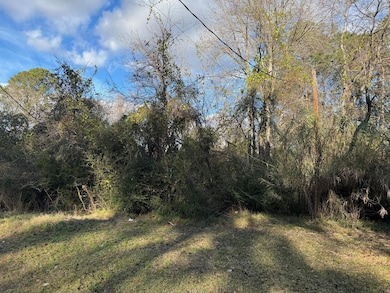
- Wooded Lot
- Tidal Wetland on Lot
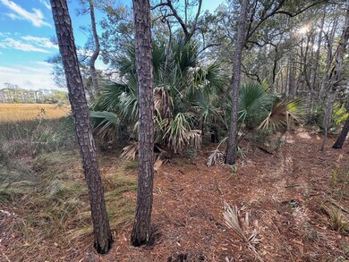
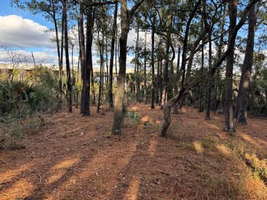
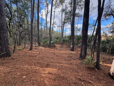
About This Lot
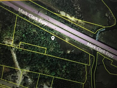
A rare opportunity on St. Thomas Island. This 3.4 acres has about a little over 100 feet of deep water frontage on Nowell Creek. A short dock should be attainable. With this parcel, you will have plenty of space to build the home of your choice and dock your boat at your private dock. Need extra storage space for your RV and all of your toys? No problem. You have the space for them all at 120 Andrew Lane. It is conveniently located between Mount Pleasant, Daniel Island and North Charleston. This property is currently zoned R1-MM, which is residential.
Property Details
Property Type
- Land
Est. Annual Taxes
- $2,206
Lot Details
- 3.4 Acre Lot
- Property fronts a marsh
- Property fronts a private road
- Dirt Road
- Wooded Lot
- Tidal Wetland on Lot
Schools
- Daniel Island Elementary And Middle School
- Philip Simmons High School
Additional Features
- Residence on Property
- Septic Tank
Community Details
Overview
- Thomas Island Subdivision
Recreation
- Wetlands on Lot
Map
Home Values in the Area
Average Home Value in this Area
Tax History
| Year | Tax Paid | Tax Assessment Tax Assessment Total Assessment is a certain percentage of the fair market value that is determined by local assessors to be the total taxable value of land and additions on the property. | Land | Improvement |
|---|---|---|---|---|
| 2024 | $2,206 | $8,665 | $8,473 | $192 |
| 2023 | $2,206 | $8,665 | $8,473 | $192 |
| 2022 | $2,126 | $7,535 | $7,240 | $295 |
| 2021 | $2,142 | $7,540 | $7,240 | $295 |
| 2020 | $2,150 | $7,535 | $7,240 | $295 |
| 2019 | $2,145 | $7,535 | $7,240 | $295 |
| 2018 | $1,993 | $6,552 | $5,994 | $558 |
| 2017 | $1,994 | $6,552 | $5,994 | $558 |
| 2016 | $2,011 | $6,550 | $5,990 | $560 |
| 2015 | $1,919 | $6,550 | $5,990 | $560 |
| 2014 | $1,798 | $6,550 | $5,990 | $560 |
| 2013 | -- | $6,550 | $5,990 | $560 |
Property History
| Date | Event | Price | Change | Sq Ft Price |
|---|---|---|---|---|
| 01/13/2025 01/13/25 | For Sale | $750,000 | -- | -- |
Purchase History
| Date | Type | Sale Price | Title Company |
|---|---|---|---|
| Quit Claim Deed | -- | None Available | |
| Deed | $448,256 | None Available | |
| Sheriffs Deed | -- | -- | |
| Interfamily Deed Transfer | -- | -- | |
| Gift Deed | -- | -- | |
| Interfamily Deed Transfer | -- | -- |
Mortgage History
| Date | Status | Loan Amount | Loan Type |
|---|---|---|---|
| Previous Owner | $50,000 | New Conventional |
Source: CHS Regional MLS
MLS Number: 25000952
APN: 271-00-02-014
Disclaimer: Certain information contained herein is derived from information provided by parties other than Homes.com. All information provided is deemed reliable, but is not guaranteed to be accurate and should be independently verified.
![]() The information is being provided by Charleston Trident MLS. Information deemed reliable but not guaranteed. Information is provided for consumers' personal, non-commercial use, and may not be used for any purpose other than the identification of potential properties for purchase. © 2025 Charleston Trident MLS. All Rights Reserved
The information is being provided by Charleston Trident MLS. Information deemed reliable but not guaranteed. Information is provided for consumers' personal, non-commercial use, and may not be used for any purpose other than the identification of potential properties for purchase. © 2025 Charleston Trident MLS. All Rights Reserved
- 1088 Saint Thomas Island Dr
- 0 Harvest Time Place
- 0 Saint Thomas Island Dr
- 138 Sandshell Dr
- 327 Megans Bay Ln
- 1036 Victoria Rd
- 840 Forrest Dr
- 104 Antilles Cir
- 779 Forrest Dr
- 00 Clements Ferry Rd
- 524 Amalie Farms Dr
- 11 Dalton St
- 178 Beresford Creek St
- 117 Lucia St
- 205 Fairchild St
- 193 Corn Planters St
- 228 Beresford Creek St
- 2 Pagett St
- 0 Pinefield Rd Unit 23016301
- 1000 Rivershore Rd
- 788 Oyster Isle Dr
- 716 Oyster Isle Dr
- 405 Intertidal Dr
- 524 Amalie Farms Dr
- 161 Grande Oaks Dr
- 350 Henslow Dr
- 480 Seven Farms Dr
- 455 Seven Farms Dr
- 900 Corby Ln
- 50 Central Island St
- 600 Bucksley Ln Unit 205
- 515 Robert Daniel Dr
- 650 Enterprise Blvd Unit Field Pea
- 650 Enterprise Blvd Unit Kale
- 650 Enterprise Blvd Unit Rosemary
- 650 Enterprise Blvd
- 1071 Barfield St
- 211 River Landing Dr Unit Alexander
- 211 River Landing Dr Unit Hertiage
- 211 River Landing Dr Unit Krawcheck
