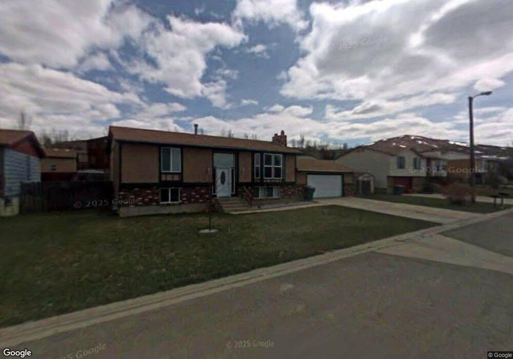
121 Arapahoe Cir Evanston, WY 82930
Estimated Value: $295,000 - $444,000
2
Beds
2
Baths
1,060
Sq Ft
$324/Sq Ft
Est. Value
About This Home
This home is located at 121 Arapahoe Cir, Evanston, WY 82930 and is currently estimated at $343,257, approximately $323 per square foot. 121 Arapahoe Cir is a home located in Uinta County with nearby schools including Evanston High School and Evanston Child Development Center.
Ownership History
Date
Name
Owned For
Owner Type
Purchase Details
Closed on
Sep 13, 2013
Sold by
Cox Marinda
Bought by
Masterson Phillip J and Masterson Melissa A
Current Estimated Value
Home Financials for this Owner
Home Financials are based on the most recent Mortgage that was taken out on this home.
Original Mortgage
$163,265
Outstanding Balance
$122,986
Interest Rate
4.41%
Mortgage Type
New Conventional
Estimated Equity
$219,080
Purchase Details
Closed on
Jan 28, 2005
Sold by
Hunt Trever M
Bought by
Gonzalez Feliciano and Gonzalez Marinda J
Home Financials for this Owner
Home Financials are based on the most recent Mortgage that was taken out on this home.
Original Mortgage
$114,725
Interest Rate
5.71%
Mortgage Type
New Conventional
Create a Home Valuation Report for This Property
The Home Valuation Report is an in-depth analysis detailing your home's value as well as a comparison with similar homes in the area
Home Values in the Area
Average Home Value in this Area
Purchase History
| Date | Buyer | Sale Price | Title Company |
|---|---|---|---|
| Masterson Phillip J | -- | None Available | |
| Gonzalez Feliciano | -- | None Available | |
| Gonzalez Feliciano | -- | None Available |
Source: Public Records
Mortgage History
| Date | Status | Borrower | Loan Amount |
|---|---|---|---|
| Open | Masterson Phillip J | $163,265 | |
| Previous Owner | Gonzalez Feliciano | $114,725 | |
| Previous Owner | Gonzalez Feliciano | $114,725 |
Source: Public Records
Tax History Compared to Growth
Tax History
| Year | Tax Paid | Tax Assessment Tax Assessment Total Assessment is a certain percentage of the fair market value that is determined by local assessors to be the total taxable value of land and additions on the property. | Land | Improvement |
|---|---|---|---|---|
| 2025 | $1,800 | $19,542 | $2,795 | $16,747 |
| 2024 | $1,800 | $26,483 | $3,726 | $22,757 |
| 2023 | $1,720 | $25,426 | $3,544 | $21,882 |
| 2022 | $1,599 | $23,491 | $2,057 | $21,434 |
| 2021 | $1,343 | $19,710 | $2,057 | $17,653 |
| 2020 | $1,152 | $16,914 | $1,873 | $15,041 |
| 2019 | $1,173 | $17,243 | $1,751 | $15,492 |
| 2018 | $0 | $15,917 | $1,844 | $14,073 |
| 2017 | $1,070 | $15,743 | $1,844 | $13,899 |
| 2016 | $1,153 | $16,953 | $1,618 | $15,335 |
| 2015 | -- | $16,470 | $1,402 | $15,068 |
| 2014 | -- | $15,490 | $0 | $0 |
Source: Public Records
Map
Nearby Homes
- 721 Sioux Dr
- 46 City View Dr
- 252 Jared Ln
- 234 Laredo Rd
- 525 8th St
- 814 Lombard St
- 155 Highridge Point
- 824 9th St
- 427 Thayer Cir
- 191 Ridge Ln
- 104 Windy Ridge Ct
- 213 Grandview
- 106 Windy Ridge Ct
- 104 Canyon Hollow Dr
- 479 Twin Ridge Ave
- 223 Barber Ave
- 221 Barber Ave
- 106 Grandview
- 442 12th St
- 1137 Main St
- 119 Arapahoe Cir
- 123 Arapahoe Cir
- 148 Apache Dr
- 146 Apache Dr
- 117 Arapahoe Cir
- 116 Hopi Ct
- 128 Hopi Ct
- 132 Arapahoe Cir
- 144 Apache Dr
- 151 Apache Dr
- 149 Apache Dr
- 126 Hopi Ct
- 153 Apache Dr
- 110 Arapahoe Cir
- 147 Apache Dr
- 147 Apache Dr Unit Cheyenne
- 399 Cheyenne Dr
- 399 Cheyenne Dr Unit Apache
- 118 Hopi Ct
- 150 Comanche Ct