

Estimated payment $585/month
Highlights
- 4.7 Acre Lot
- Views
- Rectangular Lot
About This Lot
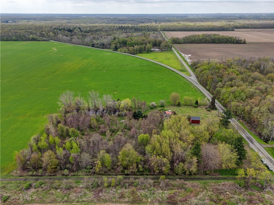
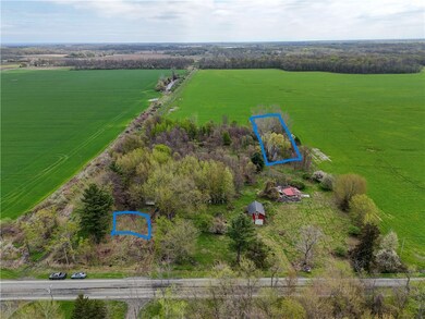
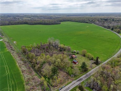
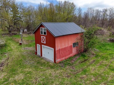
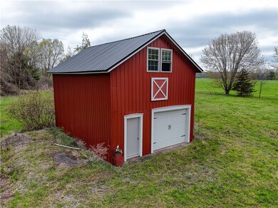
This beautiful parcel sits on 4.7 acres containing many mature trees and a pond! Lots of potential for many outdoor activities. Use it as your personal nature retreat or build something new! Property contains the existing barn for easy storage of outdoor equipment. Just a few miles west of Kendall High School on Roosevelt Highway!!
Listing Agent
Listing by Howard Hanna Brokerage Phone: 585-489-8979 License #10401373822 Listed on: 05/08/2025

Property Details
Property Type
- Land
Est. Annual Taxes
- $1,368
Year Built
- Built in 1850
Lot Details
- 4.7 Acre Lot
- Lot Dimensions are 355x551
- Rural Setting
- Rectangular Lot
- Level Lot
Parking
- Gravel Driveway
Utilities
- Well
Additional Features
- Property Views
Listing and Financial Details
- Assessor Parcel Number 343000-031-000-0001-025-001
Map
Home Values in the Area
Average Home Value in this Area
Tax History
| Year | Tax Paid | Tax Assessment Tax Assessment Total Assessment is a certain percentage of the fair market value that is determined by local assessors to be the total taxable value of land and additions on the property. | Land | Improvement |
|---|---|---|---|---|
| 2024 | $869 | $37,000 | $26,400 | $10,600 |
| 2023 | $889 | $37,000 | $26,400 | $10,600 |
| 2022 | $915 | $29,000 | $19,700 | $9,300 |
| 2021 | $907 | $29,000 | $19,700 | $9,300 |
| 2020 | $915 | $29,000 | $19,700 | $9,300 |
| 2019 | $510 | $29,000 | $19,700 | $9,300 |
| 2018 | $510 | $18,700 | $18,700 | $0 |
| 2017 | $3,495 | $116,000 | $18,700 | $97,300 |
| 2016 | $3,457 | $116,000 | $18,700 | $97,300 |
| 2015 | -- | $120,800 | $16,700 | $104,100 |
| 2014 | -- | $120,800 | $16,700 | $104,100 |
Property History
| Date | Event | Price | Change | Sq Ft Price |
|---|---|---|---|---|
| 06/24/2025 06/24/25 | Pending | -- | -- | -- |
| 05/08/2025 05/08/25 | For Sale | $85,000 | -- | -- |
Purchase History
| Date | Type | Sale Price | Title Company |
|---|---|---|---|
| Quit Claim Deed | -- | None Available | |
| Deed | $108,000 | Nat Lester Iii | |
| Deed | $108,000 | Nat Lester Iii |
Source: Upstate New York Real Estate Information Services (UNYREIS)
MLS Number: R1604464
APN: 343000-031-000-0001-025-001
Disclaimer: Certain information contained herein is derived from information provided by parties other than Homes.com. All information provided is deemed reliable, but is not guaranteed to be accurate and should be independently verified.
![]() The data relating to real estate on this web site comes in part from the Internet Data Exchange (IDX) Program of the CNYIS, UNYREIS and WNYREIS. Real estate listings held by firms other than Homes.com, LLC are marked with the IDX logo and include the Listing Broker’s Firm Name.
The data relating to real estate on this web site comes in part from the Internet Data Exchange (IDX) Program of the CNYIS, UNYREIS and WNYREIS. Real estate listings held by firms other than Homes.com, LLC are marked with the IDX logo and include the Listing Broker’s Firm Name.
Disclaimer: All information deemed reliable but not guaranteed and should be independently verified. All properties
are subject to prior sale, change or withdrawal. Neither the listing broker(s) nor Homes.com, LLC shall be responsible for any typographical errors, misinformation, misprints, and shall be held totally harmless.
© 2025 CNYIS, UNYREIS, WNYREIS. All rights reserved.
- 1750 Kent Rd
- 0 Tibet Dr Unit ONEH6319279
- 1359 Transit Rd
- 16302 Ridge Rd W
- 14918 Lakeshore Rd
- 0 Lakeshore Rd Unit R1588383
- 1790 Kendall Rd
- 2948 Lattin Rd
- 2340 Kendall Rd
- 16794 Lakeshore Rd
- v/l Sandy Creek Ln
- 14407 Lakeshore Rd
- 0 V L Sandy Creek Ln Unit LotWP001
- 14415 Oak Orchard On the Lake
- 3294 Fancher Rd
- 16562 Ridge Rd
- 2903 Kendall Rd
- 13885 Park Ave
- 3470 Hindsburg Rd
- 17095 Lakeshore Rd