

2350 S Amherst Hwy Amherst, VA 24521
Estimated payment $2,788/month
Total Views
31,637
68
Acres
$7,356
Price per Acre
2,960,338
Sq Ft Lot
About This Lot
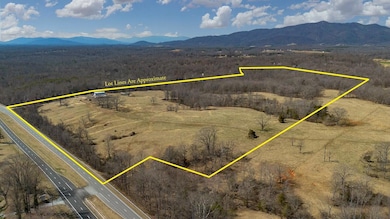
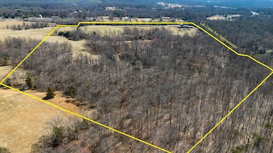
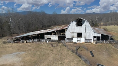
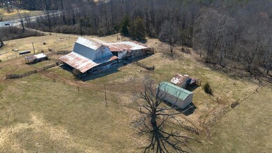
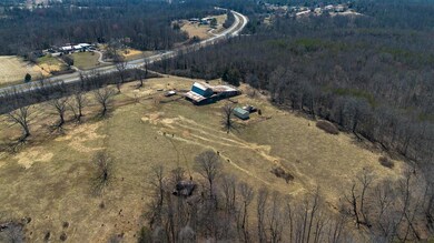
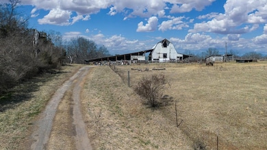
Almost 68 acres of rolling pasture and woods, featuring a classic white barn, outbuildings, a meandering creek, and existing well, offers prime agricultural and residential development potential. Zoned mostly R-1 residential with public water available, the property fronts on U.S. Rt. 29 for almost 1/4 mile and is located between Amherst (9 minutes) and Lynchburg (15 minutes). This beautiful farm with perimeter fencing has a long history of supporting livestock and is currently in land use.
Map
Property Details
Property Type
Land
Est. Annual Taxes
$318
Lot Details
0
Listing Details
- ConservationEsmnt: No
- Directions: 60 E or 29 South to Amherst, take a right onto Richmond Hwy, 2nd exit at the roundabout, right onto 29 South toward Lynchburg. Look for Real Estate sign on the right. GPS will take you to High Peak Rd but the drive to the property is before you get too High Peak Rd.
- HistoricProperty: No
- Listing Member Name: Rona M Bruce
- Listing Office Short Id: 78
- Open House Office I D: 20061211170240946497000000
- Hoa2 Or Poa: No
- Prop. Type: Lots And Land
- Subdivision Yn: No
- Lot Use: Beef Cattle, Farmland, Subdevelop
- Taxes Dollars: 1483.52
- TotalAcresApx: 67.96
- Special Features: None
- Property Sub Type: LotsLands
Interior Features
- Entry Location: Corner Lot
Exterior Features
- Exterior Features: Chickens Permitted, Horses Permitted, Outbuildings
- Road Frontage: State Road
- Street: Amherst
- Surface Water: Creek/Stream
- Tax Rate: .61
- Flood Zone: SE
- Out Buildings: Barn(s), Equipment Shed, Granary
- Fencing: Cross, Perimeter
- Topography: Pasture, Rolling, Woods
Utilities
- Sewer: None
- Utilities Available: Electric
- Water: Existing Well, Public Water Avail
Schools
- Middle School: Amherst County Middle
- High School: Amherst High
- Elementary School: Other
- High School: Amherst High
- Middle School: Amherst County Middle
Lot Info
- Future Land Use: Yes
- Zoning: Residential
- Lot Type: Acreage
Tax Info
- Tax Map Number: 124 A 31
- Tax Year: 2024
Create a Home Valuation Report for This Property
The Home Valuation Report is an in-depth analysis detailing your home's value as well as a comparison with similar homes in the area
Home Values in the Area
Average Home Value in this Area
Tax History
| Year | Tax Paid | Tax Assessment Tax Assessment Total Assessment is a certain percentage of the fair market value that is determined by local assessors to be the total taxable value of land and additions on the property. | Land | Improvement |
|---|---|---|---|---|
| 2025 | $318 | $52,100 | $36,800 | $15,300 |
| 2024 | $318 | $243,200 | $227,900 | $15,300 |
| 2023 | $1,484 | $243,200 | $227,900 | $15,300 |
| 2022 | $1,484 | $243,200 | $227,900 | $15,300 |
| 2021 | $1,484 | $243,200 | $227,900 | $15,300 |
| 2020 | $1,484 | $243,200 | $227,900 | $15,300 |
| 2019 | $1,545 | $253,300 | $227,900 | $25,400 |
| 2018 | $1,545 | $253,300 | $227,900 | $25,400 |
| 2017 | $379 | $253,300 | $227,900 | $25,400 |
| 2016 | $1,545 | $253,300 | $227,900 | $25,400 |
| 2015 | $348 | $253,300 | $227,900 | $25,400 |
| 2014 | $174 | $253,300 | $227,900 | $25,400 |
Source: Public Records
Property History
| Date | Event | Price | Change | Sq Ft Price |
|---|---|---|---|---|
| 03/18/2025 03/18/25 | For Sale | $499,900 | -- | -- |
Source: Rockbridge Highlands REALTORS®
Similar Property in Amherst, VA
Source: Rockbridge Highlands REALTORS®
MLS Number: 139143
APN: 124-A-31
Nearby Homes
- 2205 S Amherst Hwy
- 118 Father Judge Rd
- 264 N Five Forks Rd
- 109 Ned Brown Rd
- 387 Stage Rd
- 893 Cedar Gate Rd
- 839 Cedar Gate Rd
- 216 Burford Farm Rd
- 1346 S Coolwell Rd
- 1358 S Coolwell Rd
- 951 Bobwhite Rd
- S Amherst Hwy
- 124-138 Cedar Gate Rd
- 0 S Amherst Hwy Unit 360067
- 0 S Amherst Hwy Unit 336267
- 0 McIvor Ln
- 1024 Sunset Dr
- 1481 Winesap Rd
- 147 Westhaven Dr
- 71 Patrick Ct
- 117 Friendly Acres Ln
- 115 Town Center Pkwy
- 183 Loch Ln Unit 183/203 Loch
- 123 Phelps Rd
- 535 Pendleton Dr
- 2307 Bedford Ave
- 211 S Princeton Cir
- 2935 Rivermont Ave
- 221 S Princeton Cir Unit 1
- 412 Belvedere St
- 804 Rivermont Ave Unit 1
- 701 Hollins St
- 410 Court St
- 4815 Boonsboro Rd Unit A
- 1016 Jefferson St Unit 5
- 405 Harrison St Unit 2
- 4715 Boonsboro Rd
- 1200 Commerce St Unit 4
- 1220 Commerce St
- 1025 Church St Unit A