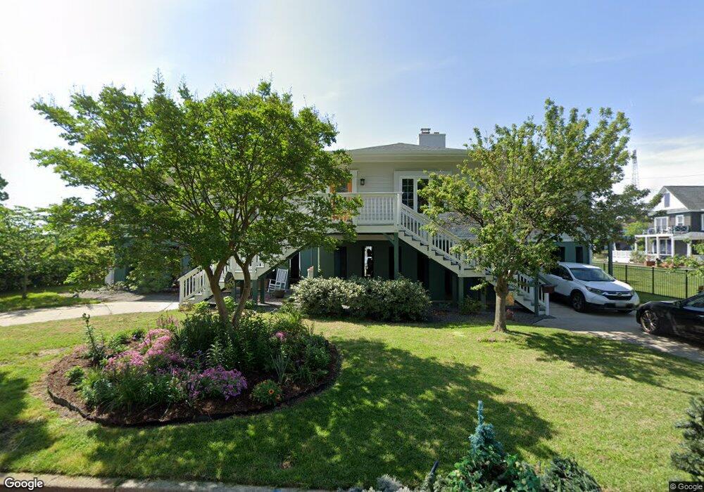
330 Syms St Hampton, VA 23669
Pasture Point NeighborhoodEstimated Value: $471,000 - $568,210
3
Beds
2
Baths
2,704
Sq Ft
$200/Sq Ft
Est. Value
About This Home
This home is located at 330 Syms St, Hampton, VA 23669 and is currently estimated at $540,303, approximately $199 per square foot. 330 Syms St is a home located in Hampton City with nearby schools including Capt. John Smith Elementary School, C. Alton Lindsay Middle School, and Phoebus High School.
Ownership History
Date
Name
Owned For
Owner Type
Purchase Details
Closed on
Jun 27, 2024
Sold by
Grisetti Gail C and Edmonds Robert C
Bought by
Glass Peter and Glass Mun Son
Current Estimated Value
Home Financials for this Owner
Home Financials are based on the most recent Mortgage that was taken out on this home.
Original Mortgage
$501,741
Outstanding Balance
$497,908
Interest Rate
6.94%
Mortgage Type
VA
Estimated Equity
$70,834
Purchase Details
Closed on
Dec 14, 2004
Sold by
Nealon Joseph
Bought by
Grisetti Gail
Home Financials for this Owner
Home Financials are based on the most recent Mortgage that was taken out on this home.
Original Mortgage
$333,701
Interest Rate
5.68%
Mortgage Type
New Conventional
Create a Home Valuation Report for This Property
The Home Valuation Report is an in-depth analysis detailing your home's value as well as a comparison with similar homes in the area
Home Values in the Area
Average Home Value in this Area
Purchase History
| Date | Buyer | Sale Price | Title Company |
|---|---|---|---|
| Glass Peter | $550,000 | Fidelity National Title | |
| Grisetti Gail | $434,000 | -- |
Source: Public Records
Mortgage History
| Date | Status | Borrower | Loan Amount |
|---|---|---|---|
| Open | Glass Peter | $501,741 | |
| Previous Owner | Grisetti Gail | $120,000 | |
| Previous Owner | Grisetti Gail | $120,000 | |
| Previous Owner | Grisetti Gail | $333,701 |
Source: Public Records
Tax History Compared to Growth
Tax History
| Year | Tax Paid | Tax Assessment Tax Assessment Total Assessment is a certain percentage of the fair market value that is determined by local assessors to be the total taxable value of land and additions on the property. | Land | Improvement |
|---|---|---|---|---|
| 2025 | $5,571 | $561,700 | $120,000 | $441,700 |
| 2024 | $5,571 | $484,400 | $120,000 | $364,400 |
| 2023 | $5,095 | $427,000 | $120,000 | $307,000 |
| 2022 | $4,654 | $394,400 | $113,900 | $280,500 |
| 2021 | $4,456 | $348,900 | $113,900 | $235,000 |
| 2020 | $3,782 | $305,000 | $113,600 | $191,400 |
| 2019 | $3,782 | $305,000 | $113,600 | $191,400 |
| 2018 | $4,197 | $305,000 | $113,600 | $191,400 |
| 2017 | $3,876 | $0 | $0 | $0 |
| 2016 | $4,296 | $338,900 | $0 | $0 |
| 2015 | $4,517 | $0 | $0 | $0 |
| 2014 | $4,749 | $376,200 | $132,800 | $243,400 |
Source: Public Records
Map
Nearby Homes
- 232 Mill Point Dr
- 243 Mill Point Dr
- 43 Miles Cary Mews
- 35 Miles Cary Mews
- 156 Mill Point Dr
- 2 Miles Cary Mews
- 418 Wine St
- 433 Cooper St
- 439 Cooper St
- 14 Myrtle St
- 222 Island Cove Ct Unit B
- 122 Cherry Acres Dr
- 210 Dockside Dr Unit A
- 407 Bridge St Unit 1E
- 411 Bridge St Unit 1C
- 453 Bridge St
- 840 Quash St
- 520 Settlers Landing Rd
- 497 Bridge St
- 227 Dockside Dr Unit C