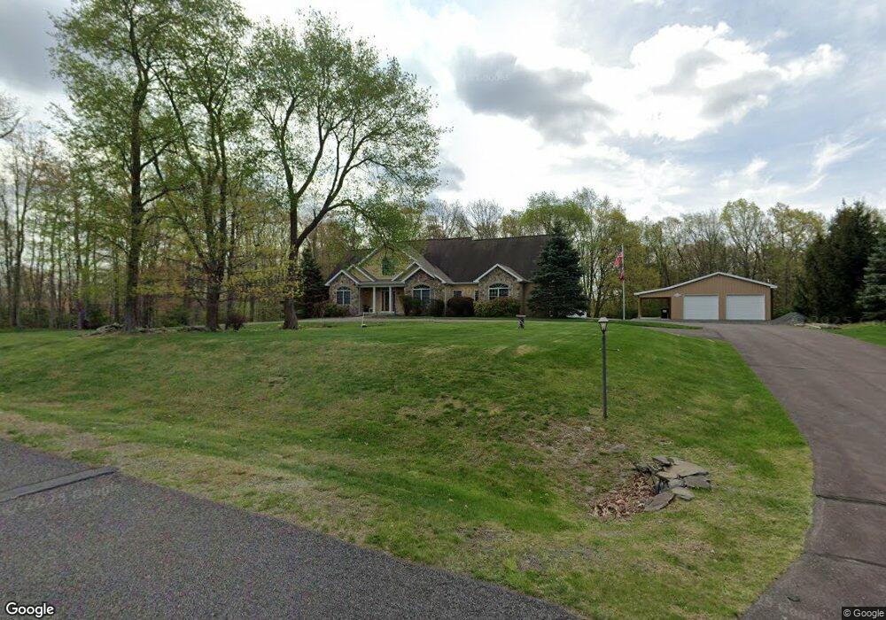
57 Kostige Rd Lakeville, PA 18438
Estimated Value: $502,000 - $759,000
3
Beds
3
Baths
2,909
Sq Ft
$227/Sq Ft
Est. Value
About This Home
This home is located at 57 Kostige Rd, Lakeville, PA 18438 and is currently estimated at $658,926, approximately $226 per square foot. 57 Kostige Rd is a home located in Wayne County with nearby schools including Wallenpaupack Area High School.
Ownership History
Date
Name
Owned For
Owner Type
Purchase Details
Closed on
Jun 27, 2025
Sold by
Kalaski Christine P
Bought by
Kalaski Christine P and Carlson Barbara L
Current Estimated Value
Purchase Details
Closed on
Jan 17, 2007
Sold by
Csc Land Development Llc
Bought by
Kalaski Robert J and Kalaski Christine P
Create a Home Valuation Report for This Property
The Home Valuation Report is an in-depth analysis detailing your home's value as well as a comparison with similar homes in the area
Home Values in the Area
Average Home Value in this Area
Purchase History
| Date | Buyer | Sale Price | Title Company |
|---|---|---|---|
| Kalaski Christine P | -- | None Listed On Document | |
| Kalaski Christine P | -- | None Listed On Document | |
| Kalaski Robert J | $49,100 | None Available |
Source: Public Records
Mortgage History
| Date | Status | Borrower | Loan Amount |
|---|---|---|---|
| Previous Owner | Kalaski Christine P | $75,000 | |
| Previous Owner | Kalaski Christine P | $69,500 |
Source: Public Records
Tax History Compared to Growth
Tax History
| Year | Tax Paid | Tax Assessment Tax Assessment Total Assessment is a certain percentage of the fair market value that is determined by local assessors to be the total taxable value of land and additions on the property. | Land | Improvement |
|---|---|---|---|---|
| 2025 | $7,998 | $549,100 | $64,700 | $484,400 |
| 2024 | $7,311 | $525,800 | $64,700 | $461,100 |
| 2023 | $10,245 | $525,800 | $64,700 | $461,100 |
| 2022 | $8,049 | $371,300 | $35,200 | $336,100 |
| 2021 | $7,906 | $371,300 | $35,200 | $336,100 |
| 2020 | $7,884 | $371,300 | $35,200 | $336,100 |
| 2019 | $7,396 | $371,300 | $35,200 | $336,100 |
| 2018 | $7,251 | $371,300 | $35,200 | $336,100 |
| 2017 | $1,698 | $371,300 | $35,200 | $336,100 |
| 2016 | $6,854 | $371,300 | $35,200 | $336,100 |
| 2014 | -- | $371,300 | $35,200 | $336,100 |
Source: Public Records
Map
Nearby Homes
- 177 Crane Rd
- 0 Crane Rd
- 2 Beverly Dr
- 10 Cove Point Cir
- 141 Cove Point Cir
- 146 Cove Point Cir
- 0 Address Withheld Unit PWBPW251950
- 140 Poplar St
- 1107 Crest Cir
- 5 Lakefront Cir Unit 206
- 20 Pine St
- 106 Hemlock Dr
- 515 Covered Bridge Dr
- 510 Covered Bridge Dr
- 477 Purdytown Turnpike
- 212 Bluebird Ct
- 116 Daniels Rd
- 390 Lakeshore Dr
- 4 Shore Line Dr
- 108 Ice Cream St
- 69 Kostige Rd
- 34 Laurie Estates
- 33 Laurie Estates
- 49 Kostige Rd
- 246 Crane Rd
- 68 Kostige Rd
- 22 Kostige Rd
- 45 Kostige Rd
- 263 Crane Rd
- 234 Crane Rd
- 41 Kostige Rd
- 12 Kostige Rd
- 25 B Paw Rd Unit B-bear
- 21 Kostige Rd
- 20 Brook Acres
- 18 Brook Acres
- 224 Crane Rd
- 187 Bear Paw Dr
- 9 Kostige Rd
- 19 Ruffed Grouse Dr