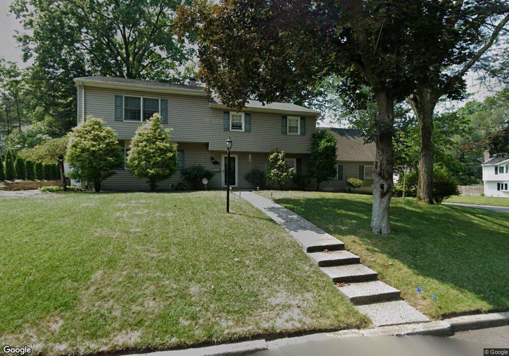
573 Palm St Township of Washington, NJ 07676
Estimated Value: $788,000 - $1,017,000
--
Bed
--
Bath
2,714
Sq Ft
$332/Sq Ft
Est. Value
About This Home
This home is located at 573 Palm St, Township of Washington, NJ 07676 and is currently estimated at $899,702, approximately $331 per square foot. 573 Palm St is a home located in Bergen County with nearby schools including Westwood Regional High School, Primoris Academy, and St. John's Academy.
Ownership History
Date
Name
Owned For
Owner Type
Purchase Details
Closed on
Aug 31, 2004
Sold by
Gordon Peter
Bought by
Lee John
Current Estimated Value
Home Financials for this Owner
Home Financials are based on the most recent Mortgage that was taken out on this home.
Original Mortgage
$350,000
Interest Rate
6.17%
Purchase Details
Closed on
Jun 15, 1999
Sold by
Cain Charles E and Cain Ursula W
Bought by
Gordon Peter L and Gordon Lanie J
Home Financials for this Owner
Home Financials are based on the most recent Mortgage that was taken out on this home.
Original Mortgage
$207,000
Interest Rate
6.99%
Mortgage Type
Balloon
Create a Home Valuation Report for This Property
The Home Valuation Report is an in-depth analysis detailing your home's value as well as a comparison with similar homes in the area
Home Values in the Area
Average Home Value in this Area
Purchase History
| Date | Buyer | Sale Price | Title Company |
|---|---|---|---|
| Lee John | $645,000 | -- | |
| Gordon Peter L | $332,000 | -- |
Source: Public Records
Mortgage History
| Date | Status | Borrower | Loan Amount |
|---|---|---|---|
| Open | Lee John | $345,000 | |
| Closed | Lee Jenna | $417,000 | |
| Closed | Lee John | $325,576 | |
| Closed | Lee John | $348,574 | |
| Previous Owner | Lee John | $350,000 | |
| Previous Owner | Gordon Peter L | $207,000 |
Source: Public Records
Tax History Compared to Growth
Tax History
| Year | Tax Paid | Tax Assessment Tax Assessment Total Assessment is a certain percentage of the fair market value that is determined by local assessors to be the total taxable value of land and additions on the property. | Land | Improvement |
|---|---|---|---|---|
| 2025 | $13,545 | $488,300 | $237,300 | $251,000 |
| 2024 | $13,213 | $488,300 | $237,300 | $251,000 |
| 2023 | $12,603 | $488,300 | $237,300 | $251,000 |
| 2022 | $12,603 | $488,300 | $237,300 | $251,000 |
| 2021 | $12,330 | $488,300 | $237,300 | $251,000 |
| 2020 | $12,134 | $488,300 | $237,300 | $251,000 |
| 2019 | $11,861 | $488,300 | $237,300 | $251,000 |
| 2018 | $11,539 | $488,300 | $237,300 | $251,000 |
| 2017 | $11,353 | $488,300 | $237,300 | $251,000 |
| 2016 | $11,275 | $488,300 | $237,300 | $251,000 |
| 2015 | $11,084 | $488,300 | $237,300 | $251,000 |
| 2014 | $10,801 | $488,300 | $237,300 | $251,000 |
Source: Public Records
Map
Nearby Homes
- 525 Colonial Blvd
- 647 Fern St
- 42 Lexington Ct Unit 42
- 151 Winchester Ct Unit 151
- 392 Lafayette Ave
- 665 Calvin St
- 667 Mckinley Ave
- 98 Wheeler Ave
- 662 Jefferson Ave
- 99 Clairmont Ave
- 72 Hillside Ave
- 762 White Birch Rd
- 68 Lincoln Ave
- 874 Ridgewood Blvd E
- 195 Fern St
- 19 Lake Dr
- 17 Sycamore Ave
- 35 Glendale Dr
- 484 Hoover Ave
- 1 Nugent Place