

0 Hot Spring Rd California Hot Springs, CA 93207
Highlights
- 14,672.6 Acre Lot
- No HOA
- Agricultural
- Creek or Stream View
- Pasture
- Lot Has A Rolling Slope
About This Lot
As of October 2024Location
Property is located two (2) miles northwest of California Hot Springs. Access to the ranch is by Deer Creek and Old Control Road, which are county maintained gravel and dirt roads.
Size
+/-14,672.66 Assessed Acres
Property Description
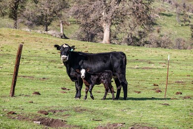
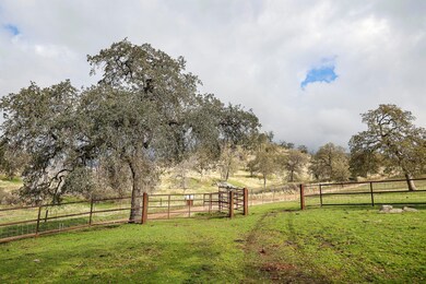
Property has been utilized as a cattle ranch. The entire ranch is perimeter fenced and cross fenced in 11 main pastures and 13 smaller gathering fields. Vegetation consists of native annual grasses, oak trees, pine trees, sycamore trees, and some brush.
Water
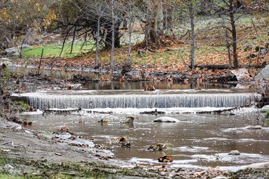
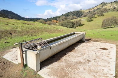
Property has two (2) drilled wells and one (1) Artesian well. There are multiple springs and creeks located throughout the property.
Year Round Creeks: Deer Creek, Rube Creek, Tyler Creek, and Cold Springs Creek.
Seasonal Creeks: Gordon Creek, Gibbons Creek, Cain Springs Creek, Moton Flat Creek, Column Creek, and Cattle Creek.
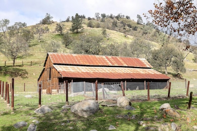
Buildings
There are two (2) homes on the property. The main +/-3,024 sq. ft. home was built in the 1920's. The home has six (6) bedrooms, two (2) bathrooms, a kitchen, dining room, and living room. The employee home is +/-1,040 sq. ft. and has two (2) bedrooms, one (1) bathroom, a kitchen, living room, and dining room.
The property also has a +/-336 sq. ft. tack room, a storage shed, a +/-3,000 sq. ft. barn, and five (5) working corrals.
Topography
Topography varies from moderately rolling to very steep. The elevation on the ranch ranges from 1,400′ to 4.500′. See 'Topographic Map' for details.
Zoning
Property is zoned AF – Foothill Agricultural Zone. All land is enrolled in The Williamson Act.
Soil
Soil Maps are available upon request.
Groundwater Disclosure
The Sustainable Groundwater Management Act (SGMA) requires groundwater basins to be sustainable by 2040. SGMA requires a Groundwater Sustainability Plan (GSP) by 2020. Said plans may limit ground water pumping. For more information please visit the SGMA website at www.sgma.water.ca.gov/portal/
Property Details
Property Type
- Land
Lot Details
- 14,672.6 Acre Lot
- The property's road front is unimproved
- Property fronts a county road
- Dirt Road
- Irregular Lot
- Lot Has A Rolling Slope
- Call office for entire list
- Zoning described as AF - Foothill Agricultural.
Property Views
- Creek or Stream
- Hills
Farming
- Agricultural
- Pasture
Utilities
- Propane
- Well
- Septic Tank
Community Details
- No Home Owners Association
Listing and Financial Details
- Assessor Parcel Number 325070011000
Map
Home Values in the Area
Average Home Value in this Area
Property History
| Date | Event | Price | Change | Sq Ft Price |
|---|---|---|---|---|
| 10/31/2024 10/31/24 | Sold | $12,750,000 | -12.2% | -- |
| 12/28/2023 12/28/23 | Pending | -- | -- | -- |
| 08/21/2023 08/21/23 | For Sale | $14,525,933 | 0.0% | -- |
| 06/26/2023 06/26/23 | Pending | -- | -- | -- |
| 12/22/2022 12/22/22 | For Sale | $14,525,933 | -- | -- |
Source: Tulare County MLS
MLS Number: 221570
Disclaimer: Certain information contained herein is derived from information provided by parties other than Homes.com. All information provided is deemed reliable, but is not guaranteed to be accurate and should be independently verified.
![]() Based on information from the Tulare County Association of REALTORS®. All data, including all measurements and calculations of area, is obtained from various sources and has not been, and will not be, verified by broker or MLS. All information should be independently reviewed and verified for accuracy. Properties may or may not be listed by the office/agent presenting the information.
Based on information from the Tulare County Association of REALTORS®. All data, including all measurements and calculations of area, is obtained from various sources and has not been, and will not be, verified by broker or MLS. All information should be independently reviewed and verified for accuracy. Properties may or may not be listed by the office/agent presenting the information.
- 42757 Capanero Oaks Ct
- 276 Capinero Dr
- 0 1 34 Ac Lt 38 Rs Ls 9-73 Unit SR24240845
- 0 1 34 Ac Lt 38 Rs Ls 9-73 Unit 202412117
- 0 1 17 Ac Lot 32 Rs Ls 9-73 Unit SR24240880
- 0 Unit 202412122
- 0 Sherwood Ave Unit 202403316
- 39334 Old Stage Rd
- 28002 Avenue 56
- Lot 10 Capanero Oaks Ct
- 1172 Creekside Place W
- 1182 Creekside Place W
- 29827 Avenue 176
- 279 Green River Trail
- 340 Cedar Brook Trail
- 356 Cedar Brook Trail
- 451 Cedar Brook Trail
- 44178 Pine Flat Dr
- 39334 M-3
- 184 Rabbit Foot Trail