
0 W Indian School Rd Unit 6852979 Unincorporated County, AZ 00000
Estimated payment $11,940/month
Highlights
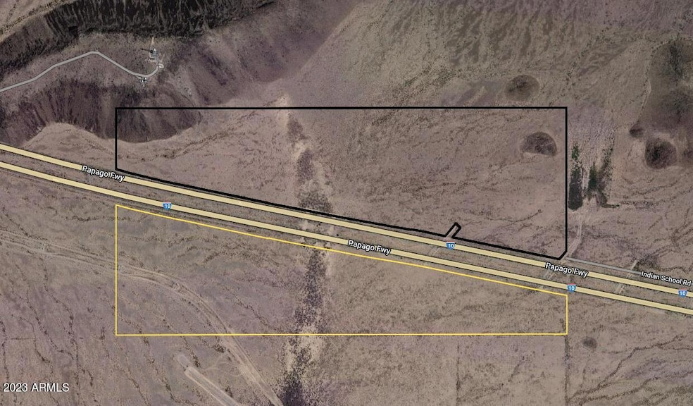
- 150.46 Acre Lot
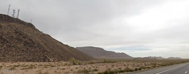
- Mountain View
- No HOA
About This Lot
This home is located at 0 W Indian School Rd Unit 6852979, Unincorporated County, AZ 00000 and is currently priced at $2,100,000. 0 W Indian School Rd Unit 6852979 is a home located in Maricopa County with nearby schools including Arlington Elementary School and Buckeye Union High School.

Property Details
Property Type
- Land
Est. Annual Taxes
- $2,630
Lot Details
- 150.46 Acre Lot
- Property is zoned R-43
Property Views
- Mountain Views
Schools
- Arlington Elementary School
Community Details
- No Home Owners Association
Listing and Financial Details
- Assessor Parcel Number 506-30-001-A
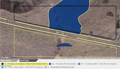
Map
Home Values in the Area
Average Home Value in this Area
Tax History
| Year | Tax Paid | Tax Assessment Tax Assessment Total Assessment is a certain percentage of the fair market value that is determined by local assessors to be the total taxable value of land and additions on the property. | Land | Improvement |
|---|---|---|---|---|
| 2025 | $2,630 | $26,863 | $26,863 | -- |
| 2024 | $2,538 | $25,584 | $25,584 | -- |
| 2023 | $2,538 | $26,880 | $26,880 | $0 |
| 2022 | $2,505 | $23,205 | $23,205 | $0 |
| 2021 | $3,568 | $31,755 | $31,755 | $0 |
| 2020 | $3,551 | $44,325 | $44,325 | $0 |
| 2019 | $3,434 | $28,695 | $28,695 | $0 |
| 2018 | $3,398 | $28,695 | $28,695 | $0 |
| 2017 | $3,241 | $27,855 | $27,855 | $0 |
| 2016 | $3,207 | $35,415 | $35,415 | $0 |
| 2015 | $3,350 | $43,344 | $43,344 | $0 |
Property History
| Date | Event | Price | Change | Sq Ft Price |
|---|---|---|---|---|
| 04/17/2025 04/17/25 | For Sale | $2,100,000 | -- | -- |
Deed History
| Date | Type | Sale Price | Title Company |
|---|---|---|---|
| Quit Claim Deed | -- | -- | |
| Interfamily Deed Transfer | -- | None Available | |
| Interfamily Deed Transfer | $78,500 | None Available | |
| Interfamily Deed Transfer | -- | None Available | |
| Quit Claim Deed | -- | -- |
Source: Arizona Regional Multiple Listing Service (ARMLS)
MLS Number: 6852979
APN: 506-30-001A
Disclaimer: Certain information contained herein is derived from information provided by parties other than Homes.com. All information provided is deemed reliable, but is not guaranteed to be accurate and should be independently verified.
![]() All information should be verified by the recipient and none is guaranteed as accurate by ARMLS
All information should be verified by the recipient and none is guaranteed as accurate by ARMLS
Listing Information presented by local MLS brokerage: Ten-X, local REALTOR®- Arlene Richardson - (888)-952-6393
- 0 W 491st Ave Ave #12 Ave Unit 12
- 490 W Lotus Ln Unit 29
- 0 Lotus Ln Unit 39 6827243
- 0 Lotus Ln Unit 34 6827233
- 48900 W Salome Hwy
- 49XXX W Ivy Ln Unit 41
- 4291 N 489th Ave
- 4289 N 489th Ave
- 4293 N 489th Ave
- 470XX N 475th Ave
- 0 S 483rd(approx) 4 Ave Unit 4
- 0 S 483rd(approx) 5 Ave Unit 5
- 0 S 483rd(approx) 3 Ave Unit 3
- 0 S 483rd(approx) 2 Ave Unit 2
- 0 S 483(approx) Ave Unit 1
- 487th Ave N of Indian School Rd A --
- 487th Ave N of Indian School Rd B --
- 475th Ave & Salome Hwy
- 470XF W Highland Ave
- 475XXX Unit A