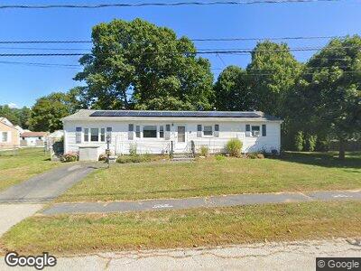
10 Wallis Rd Portsmouth, NH 03801
Estimated Value: $541,000 - $797,000
3
Beds
2
Baths
1,726
Sq Ft
$357/Sq Ft
Est. Value
About This Home
This home is located at 10 Wallis Rd, Portsmouth, NH 03801 and is currently estimated at $616,032, approximately $356 per square foot. 10 Wallis Rd is a home located in Rockingham County with nearby schools including Mary C. Dondero Elementary School, Portsmouth Middle School, and Portsmouth High School.
Ownership History
Date
Name
Owned For
Owner Type
Purchase Details
Closed on
Mar 24, 2008
Sold by
Rossi Katherine A
Bought by
Brophy Janet A
Current Estimated Value
Home Financials for this Owner
Home Financials are based on the most recent Mortgage that was taken out on this home.
Original Mortgage
$208,000
Interest Rate
5.75%
Mortgage Type
Purchase Money Mortgage
Create a Home Valuation Report for This Property
The Home Valuation Report is an in-depth analysis detailing your home's value as well as a comparison with similar homes in the area
Home Values in the Area
Average Home Value in this Area
Purchase History
| Date | Buyer | Sale Price | Title Company |
|---|---|---|---|
| Brophy Janet A | $260,000 | -- |
Source: Public Records
Mortgage History
| Date | Status | Borrower | Loan Amount |
|---|---|---|---|
| Open | Brophy Janet A | $25,000 | |
| Open | Brophy Janet A | $195,700 | |
| Closed | Brophy Janet A | $20,000 | |
| Closed | Rossi Katherine A | $217,745 | |
| Closed | Rossi Katherine A | $208,000 | |
| Previous Owner | Rossi Katherine A | $10,000 |
Source: Public Records
Tax History Compared to Growth
Tax History
| Year | Tax Paid | Tax Assessment Tax Assessment Total Assessment is a certain percentage of the fair market value that is determined by local assessors to be the total taxable value of land and additions on the property. | Land | Improvement |
|---|---|---|---|---|
| 2024 | $5,678 | $507,900 | $240,800 | $267,100 |
| 2023 | $4,963 | $307,700 | $136,500 | $171,200 |
| 2022 | $4,677 | $307,700 | $136,500 | $171,200 |
| 2021 | $4,625 | $307,700 | $136,500 | $171,200 |
| 2020 | $4,523 | $307,700 | $136,500 | $171,200 |
| 2019 | $4,558 | $306,700 | $136,500 | $170,200 |
| 2018 | $4,738 | $299,100 | $146,000 | $153,100 |
| 2017 | $4,600 | $299,100 | $146,000 | $153,100 |
| 2016 | $4,110 | $241,200 | $113,300 | $127,900 |
| 2015 | $4,050 | $241,200 | $113,300 | $127,900 |
| 2014 | $4,503 | $248,800 | $123,600 | $125,200 |
| 2013 | $4,456 | $248,800 | $123,600 | $125,200 |
| 2012 | $4,365 | $248,700 | $123,600 | $125,100 |
Source: Public Records
Map
Nearby Homes
- 50 Suzanne Dr
- 380 Ocean Rd Unit 17
- 21 Desfosses Ave
- 122 Bluefish Blvd
- 148 Codfish Corner Rd
- 2102 White Cedar Blvd
- 911 White Cedar Blvd
- 505 White Cedar Blvd
- 80 Constitution Ave Unit 328
- 80 Constitution Ave Unit 224
- 80 Constitution Ave Unit 222
- 80 Constitution Ave Unit 321
- 80 Constitution Ave Unit 419
- 80 Constitution Ave Unit 403
- 59 Liberty Common
- 50 Fowler Dr
- 44 Fowler Dr
- 38 Fowler Dr
- 32 Fowler Dr
- 190 Lafayette Rd