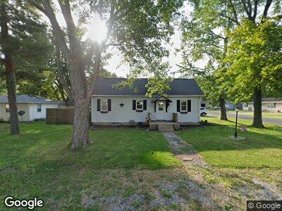
101 S Cory St Tolono, IL 61880
Estimated Value: $170,000 - $194,000
3
Beds
2
Baths
1,166
Sq Ft
$155/Sq Ft
Est. Value
About This Home
This home is located at 101 S Cory St, Tolono, IL 61880 and is currently estimated at $180,962, approximately $155 per square foot. 101 S Cory St is a home located in Champaign County with nearby schools including Unity High School.
Ownership History
Date
Name
Owned For
Owner Type
Purchase Details
Closed on
Dec 15, 2017
Sold by
Dixon Michael L
Bought by
Lindsay Laura
Current Estimated Value
Home Financials for this Owner
Home Financials are based on the most recent Mortgage that was taken out on this home.
Original Mortgage
$96,400
Interest Rate
3.94%
Mortgage Type
New Conventional
Purchase Details
Closed on
Mar 28, 2012
Sold by
Williams Brad and Williams Rae Ann
Bought by
Dixon Michael L
Home Financials for this Owner
Home Financials are based on the most recent Mortgage that was taken out on this home.
Original Mortgage
$118,086
Interest Rate
3.9%
Mortgage Type
New Conventional
Create a Home Valuation Report for This Property
The Home Valuation Report is an in-depth analysis detailing your home's value as well as a comparison with similar homes in the area
Home Values in the Area
Average Home Value in this Area
Purchase History
| Date | Buyer | Sale Price | Title Company |
|---|---|---|---|
| Lindsay Laura | $120,500 | None Available | |
| Dixon Michael L | $117,000 | None Available |
Source: Public Records
Mortgage History
| Date | Status | Borrower | Loan Amount |
|---|---|---|---|
| Open | Lindsay Laura | $115,250 | |
| Closed | Lindsay Laura | $96,400 | |
| Previous Owner | Dixon Michael L | $118,086 | |
| Previous Owner | Williams Brad | $96,477 | |
| Previous Owner | Williams Brad A | $100,000 | |
| Previous Owner | Williams Brad A | $82,000 | |
| Previous Owner | Williams Brad | $81,200 |
Source: Public Records
Tax History Compared to Growth
Tax History
| Year | Tax Paid | Tax Assessment Tax Assessment Total Assessment is a certain percentage of the fair market value that is determined by local assessors to be the total taxable value of land and additions on the property. | Land | Improvement |
|---|---|---|---|---|
| 2023 | $2,628 | $47,110 | $7,420 | $39,690 |
| 2022 | $2,470 | $43,790 | $6,900 | $36,890 |
| 2021 | $2,341 | $41,550 | $6,550 | $35,000 |
| 2020 | $2,306 | $40,610 | $6,400 | $34,210 |
| 2019 | $2,459 | $40,050 | $6,310 | $33,740 |
| 2018 | $2,430 | $40,050 | $6,310 | $33,740 |
| 2017 | $2,431 | $38,330 | $6,040 | $32,290 |
| 2016 | $2,348 | $36,640 | $5,770 | $30,870 |
| 2015 | $2,298 | $35,330 | $5,560 | $29,770 |
| 2014 | $2,341 | $35,900 | $5,650 | $30,250 |
| 2013 | $2,289 | $35,900 | $5,650 | $30,250 |
Source: Public Records
Map
Nearby Homes
- 301 Philip Dr
- 307 S Elizabeth St
- 0 County Road 700 Rd N Unit RMAQC4259116
- 201 S 1st St
- 112 Shiloh Dr
- 105 Astoria Dr
- 102 Astoria Dr
- 115 Astoria Dr
- 5 Cedar Grove Ct
- 1004 Cascade Dr
- 10 Fletcher Ct
- 209 E Market St
- 1473 Mauries Way
- 306 Sutton St
- 411 Newhaven Ln
- 210 Denton Dr
- 313 W Church St
- 1505 Winterberry Rd
- 103 Yorkminster Ln Unit 9
- 104 Yorkminster Ln Unit 10