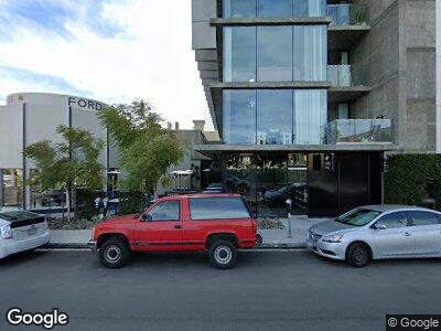
1011 Fort Stockton Dr San Diego, CA 92103
Mission Hills Neighborhood
--
Bed
--
Bath
2,428
Sq Ft
0.28
Acres
About This Home
This home is located at 1011 Fort Stockton Dr, San Diego, CA 92103. 1011 Fort Stockton Dr is a home located in San Diego County with nearby schools including Grant K-8, Richard Henry Dana Middle School, and Roosevelt International Middle School.
Ownership History
Date
Name
Owned For
Owner Type
Purchase Details
Closed on
Jun 8, 2020
Sold by
Mbt Exchange Llc
Bought by
Fort Apartments Llc
Purchase Details
Closed on
Mar 9, 2016
Sold by
Sequoian Investments
Bought by
Mbt Exchange Llc
Purchase Details
Closed on
Nov 19, 2015
Sold by
Stalnaker Neil
Bought by
Sequoian Investments
Purchase Details
Closed on
Aug 6, 2015
Sold by
Stalnaker Neil
Bought by
Stalnaker Neil
Purchase Details
Closed on
Dec 4, 2013
Sold by
Stalnaker Hamilton G and Stalnaker Hamilton G
Bought by
Stalnaker Hamilton G and Stalnaker Beata S
Create a Home Valuation Report for This Property
The Home Valuation Report is an in-depth analysis detailing your home's value as well as a comparison with similar homes in the area
Home Values in the Area
Average Home Value in this Area
Purchase History
| Date | Buyer | Sale Price | Title Company |
|---|---|---|---|
| Fort Apartments Llc | $4,758,500 | Ticor Title Ncs | |
| Mbt Exchange Llc | $1,800,000 | Ticor Title Company Of Ca | |
| Sequoian Investments | $1,200,000 | First American Title | |
| Stalnaker Neil | -- | None Available | |
| Stalnaker Hamilton G | -- | None Available |
Source: Public Records
Mortgage History
| Date | Status | Borrower | Loan Amount |
|---|---|---|---|
| Previous Owner | Broomhill 1031 Llc | $33,500,000 | |
| Previous Owner | Mbt Exchange Llc | $0 | |
| Previous Owner | Mbt Exchange Llc | $8,682,000 |
Source: Public Records
Tax History Compared to Growth
Tax History
| Year | Tax Paid | Tax Assessment Tax Assessment Total Assessment is a certain percentage of the fair market value that is determined by local assessors to be the total taxable value of land and additions on the property. | Land | Improvement |
|---|---|---|---|---|
| 2024 | $203,603 | $16,511,910 | $2,144,403 | $14,367,507 |
| 2023 | $199,113 | $16,188,148 | $2,102,356 | $14,085,792 |
| 2022 | $193,786 | $15,870,734 | $2,061,134 | $13,809,600 |
| 2021 | $192,421 | $15,559,544 | $2,020,720 | $13,538,824 |
| 2020 | $203,005 | $16,451,022 | $1,964,982 | $14,486,040 |
| 2019 | $195,310 | $15,798,453 | $1,926,453 | $13,872,000 |
| 2018 | $81,009 | $6,888,680 | $1,888,680 | $5,000,000 |
| 2017 | $21,567 | $1,836,000 | $1,734,000 | $102,000 |
| 2016 | $5,650 | $473,581 | $420,510 | $53,071 |
| 2015 | $5,566 | $466,468 | $414,194 | $52,274 |
| 2014 | -- | $457,332 | $406,081 | $51,251 |
Source: Public Records
Map
Nearby Homes
- 1214 Washington Place
- 1329 Fort Stockton Dr
- 0 Bush St Unit (35-38) 240005385
- 4067 Palmetto Way
- 4057 Brant St Unit 7
- 411 University Place
- 3929 Pringle St
- 836 W Pennsylvania Ave Unit 216
- 3972 Albatross St Unit 203
- 4180 Albatross Dr
- 1728 W Lewis St
- 4080 Front St Unit 309
- 843 Vanderbilt Place
- 1339 W Pennsylvania Ave
- 1748 W Arbor Dr
- 3781 Brant St
- 4095 Front St
- 4328 Plumosa Way Unit 1826
- 1780 Torrance St
- 1830 Fort Stockton Dr
