


1019 Montcalm Dr Livermore, CO 80536
2.66
Acres
$31,955
Price per Acre
115,870
Sq Ft Lot
Highlights
- Access To Lake
- Wooded Lot
- Hiking Trails
- Mountainous Lot
- Corner Lot
- Cul-De-Sac
About This Lot
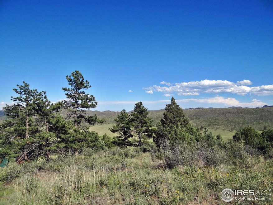
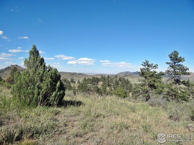
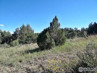
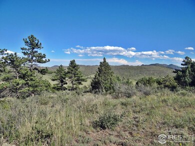
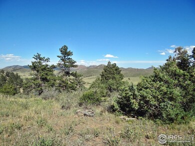
As of April 2025Private and beautiful property located in the mountain of Northern Colorado. This 2.66-acre lot is a great find with a wonderful view, large rock outcroppings (really cool), pines and juniper cedars. Property has a partial driveway added, several potential building or camping sites, power is there just needing a meter installed, quaint little storage shed tucked in the trees and rocks. GVM provides road maintenance, snow plowing, trash drop-off ($65/yr), sewer dump, potable water fill areas, community room and a small park.
Property Details
Property Type
- Land
Lot Details
- 2.66 Acre Lot
- Property fronts a private road
- Dirt Road
- Cul-De-Sac
- Unincorporated Location
- Rock Outcropping
- Corner Lot
- Steep Slope
- Mountainous Lot
- Wooded Lot
- Property is zoned E- Res
HOA Fees
Schools
- Red Feather Elementary School
- Cache La Poudre Middle School
- Poudre High School
Utilities
- High Speed Internet
Listing and Financial Details
- Assessor Parcel Number R0755265
Community Details
Overview
- Association fees include common amenities, trash, snow removal
- Glacier View Meadows Subdivision
Amenities
- Recreation Room
Recreation
- Park
- Hiking Trails
- Access To Lake
Map
Create a Home Valuation Report for This Property
The Home Valuation Report is an in-depth analysis detailing your home's value as well as a comparison with similar homes in the area
Home Values in the Area
Average Home Value in this Area
Property History
| Date | Event | Price | Change | Sq Ft Price |
|---|---|---|---|---|
| 04/01/2025 04/01/25 | Sold | $85,000 | -3.4% | -- |
| 03/13/2025 03/13/25 | Price Changed | $88,000 | -10.2% | -- |
| 10/15/2024 10/15/24 | Price Changed | $98,000 | -10.9% | -- |
| 07/04/2024 07/04/24 | For Sale | $110,000 | -- | -- |
Source: IRES MLS
Tax History
| Year | Tax Paid | Tax Assessment Tax Assessment Total Assessment is a certain percentage of the fair market value that is determined by local assessors to be the total taxable value of land and additions on the property. | Land | Improvement |
|---|---|---|---|---|
| 2025 | $1,779 | $18,972 | $18,972 | -- |
| 2024 | $1,779 | $18,972 | $18,972 | -- |
| 2022 | $930 | $9,599 | $9,599 | $0 |
| 2021 | $914 | $9,599 | $9,599 | $0 |
| 2020 | $613 | $6,380 | $6,380 | $0 |
| 2019 | $615 | $6,380 | $6,380 | $0 |
| 2018 | $780 | $8,700 | $8,700 | $0 |
| 2017 | $777 | $8,700 | $8,700 | $0 |
| 2016 | $234 | $2,610 | $2,610 | $0 |
| 2015 | $232 | $2,610 | $2,610 | $0 |
| 2014 | $351 | $3,920 | $3,920 | $0 |
Source: Public Records
Deed History
| Date | Type | Sale Price | Title Company |
|---|---|---|---|
| Special Warranty Deed | $85,000 | None Listed On Document | |
| Warranty Deed | $35,000 | Security Title | |
| Interfamily Deed Transfer | -- | -- | |
| Warranty Deed | $12,000 | -- |
Source: Public Records
Similar Properties in the area
-
$99,900
- Land
- 2.5 Acres
- $39,960 per Acre
- 1756 Eiger Rd
- Livermore, CO
Escape to your own slice of paradise with this picturesque 2.5-acre lot nestled in the tranquil Glacier View Community. Positioned just two miles from the entrance, this property offers a serene retreat, far removed from the stresses of daily life while still being conveniently accessible. As you step onto the lot, you are immediately enveloped by the breathtaking mountain scenery that defines
Trevor Okamoto Thrive Real Estate Group
-
$76,900
- Land
- 2.79 Acres
- $27,563 per Acre
- 609 Eiger Rd
- Livermore, CO
Great location - corner lot w/easy access. Build your peaceful country retreat or bring your RV (6mth allowance per yr). Walk to fishing pond & public baths. Electricity available nearby. Enjoy the hiking/biking trails. Glacier View Meadows is located near the Arapaho/Roosevelt National Forest along the Front Range of the Colorado Rockies, northwest of Fort Collins, Colorado. Enjoy the wildlife
Vicki Satrom Equity Realty & Marketing LLC
-
$99,000
- Land
- 3.03 Acres
- $32,673 per Acre
- 173 Grays Peak Ct
- Glacier View Meadows, CO
This beautiful 3-acre property in Glacier View Meadows offers breathtaking mountain and valley views. Located on a quiet cul-de-sac, it borders Roosevelt National Forest, providing direct access to miles of hiking, wildlife, a natural spring and outdoor adventure. The land features a mix of open meadows and trees, creating an ideal setting for a future home or getaway retreat. Enjoy the peace and
EMPOWERHOME Team Keller Williams DTC
Source: IRES MLS
MLS Number: 1013521
APN: 29251-05-052
Disclaimer: Certain information contained herein is derived from information provided by parties other than Homes.com. All information provided is deemed reliable, but is not guaranteed to be accurate and should be independently verified.
![]() Information source: Information and Real Estate Services, LLC. Provided for limited non-commercial use only under IRES Rules © Copyright IRES.
Information source: Information and Real Estate Services, LLC. Provided for limited non-commercial use only under IRES Rules © Copyright IRES.
Listing information is provided exclusively for consumers' personal, non-commercial use and may not be used for any purpose other than to identify prospective properties consumers may be interested in purchasing.
Information deemed reliable but not guaranteed by the MLS.
Nearby Homes
- 120 Montcalm Dr
- 324 Le Conte Dr
- 565 Le Conte Dr
- 1737 Eiger Rd
- 1756 Eiger Rd
- 136 Parkview Peak Dr
- 609 Eiger Rd
- 89 Arikaree Peak Dr
- 429 Walk About Rd
- 62 White Slide Mountain Ct
- 679 Mount Massive Dr
- 634 Meadow Mountain Dr
- 181 Meadow Mountain Dr
- 64 Bobcat Mountain Ct
- 443 Meadow Mountain Dr
- 59 Bobcat Mountain Ct
- 9 Mummy View Ct
- 92 Mount Massive Dr
- 1360 Meadow Mountain Dr
- 38 Carson Peak Ct