


11777 Old Baltimore Pike Beltsville, MD 20705
Konterra NeighborhoodEstimated payment $34,261/month
Highlights
- 17.98 Acre Lot
- Corner Lot
- No HOA
- Wooded Lot
About This Lot
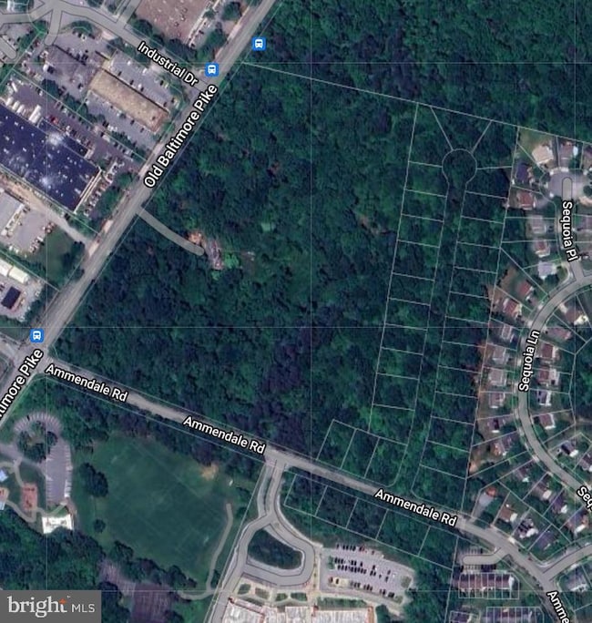
This expansive wooded property with over 29-acres presents a remarkable investment opportunity for developers and builders. It includes a 17.98-acre parcel (Tax Map 0013, Parcel 35) plus an additional 34 recorded lots designated for single-family detached homes. The Oaklodge Farm Acres subdivision comprises Lots 1-29 (Tax Map 0013/Block A) and Lots 1-5 (Tax Map 0013/Block B), all zoned RSF95 with a minimum lot size of 9,500 sq. ft. (0.218 acres) totalling 8.13 acres. Additionally, there is a 3.18 acre easement for public use, altogether the combined land is over 29 acres. The subdivision is accessed from Ammendale Road and benefits from existing county water and sewer lines along Old Baltimore Pike and Ammendale Road. It is located across from Vansville Elementary School and the Vansville Recreation Center and Park. The property offers significant potential, whether for development using the recorded subdivision lots or exploring alternative uses by combining all parcels. The 17.98-acre parcel also features an old, deteriorated building that once served as a hotel lodge, along with a few smaller shed structures. This property’s prime location offers outstanding convenience, situated just off Rt. 1/Baltimore Avenue with quick access to major highways including Rt. 200, I-95, I-495, and the Baltimore-Washington Parkway. The Muirkirk MARC train station is only minutes away, providing additional commuting options. A variety of nearby shopping, dining, and entertainment options enhance the appeal of this highly desirable area. Do not enter the deteriorated structure on property. All Buyers and Buyer's Agents must sign a Hold Harmless before accessing the property.
Property Details
Property Type
- Land
Est. Annual Taxes
- $9,278
Lot Details
- 17.98 Acre Lot
- Corner Lot
- Wooded Lot
- *See property description*
- Subdivision Possible
- Property is zoned RSF95
Utilities
- Public Hookup Available For Water
Community Details
- No Home Owners Association
Listing and Financial Details
- Assessor Parcel Number 17010044032
Map
Home Values in the Area
Average Home Value in this Area
Tax History
| Year | Tax Paid | Tax Assessment Tax Assessment Total Assessment is a certain percentage of the fair market value that is determined by local assessors to be the total taxable value of land and additions on the property. | Land | Improvement |
|---|---|---|---|---|
| 2024 | $9,320 | $624,367 | $624,367 | $0 |
| 2023 | $8,022 | $537,033 | $0 | $0 |
| 2022 | $6,724 | $449,700 | $449,700 | $0 |
| 2021 | $6,724 | $449,700 | $449,700 | $0 |
| 2020 | $6,724 | $449,700 | $449,700 | $0 |
| 2019 | $6,724 | $449,700 | $449,700 | $0 |
| 2018 | $6,724 | $449,700 | $449,700 | $0 |
| 2017 | $6,724 | $449,700 | $0 | $0 |
| 2016 | -- | $449,700 | $0 | $0 |
| 2015 | $9,584 | $449,700 | $0 | $0 |
| 2014 | $9,584 | $449,700 | $0 | $0 |
Property History
| Date | Event | Price | Change | Sq Ft Price |
|---|---|---|---|---|
| 03/19/2025 03/19/25 | Pending | -- | -- | -- |
| 11/14/2024 11/14/24 | For Sale | $6,000,000 | -- | -- |
Deed History
| Date | Type | Sale Price | Title Company |
|---|---|---|---|
| Deed | $150,000 | -- |
Source: Bright MLS
MLS Number: MDPG2131616
APN: 01-0044032
Disclaimer: Certain information contained herein is derived from information provided by parties other than Homes.com. All information provided is deemed reliable, but is not guaranteed to be accurate and should be independently verified.
![]() The data relating to real estate for sale on this website appears in part through the BRIGHT Internet Data Exchange program, a voluntary cooperative exchange of property listing data between licensed real estate brokerage firms, and is provided by BRIGHT through a licensing agreement.
The data relating to real estate for sale on this website appears in part through the BRIGHT Internet Data Exchange program, a voluntary cooperative exchange of property listing data between licensed real estate brokerage firms, and is provided by BRIGHT through a licensing agreement.
Listing information is from various brokers who participate in the Bright MLS IDX program and not all listings may be visible on the site.
The property information being provided on or through the website is for the personal, non-commercial use of consumers and such information may not be used for any purpose other than to identify prospective properties consumers may be interested in purchasing.
Some properties which appear for sale on the website may no longer be available because they are for instance, under contract, sold or are no longer being offered for sale.
Property information displayed is deemed reliable but is not guaranteed.
Copyright 2025 Bright MLS, Inc.
- 11431 Hawk Ridge Ct
- 11309 Broken Bow Ct
- 11714 Ellington Dr
- 11505 Old Baltimore Pike
- 7603 Barkwood Ct
- Lots 48-49 Highview Ave
- Lots 44-47 Highview Ave
- 10644 Gross Ln
- 4915 Lincoln Ave
- 7230 Brickyard Station Dr
- Lots 10,11 Rinard Ave
- 12515 Rustic Rock Ln
- 12526 Adobe Alley
- Lots 48-50 Rinard Ave
- Lots 28,29 Rinard Ave
- 7108 Rowlock Alley
- Lots 6,7 Rinard Ave
- Lots 50-52 Rinard Ave
- 4913 Odell Rd
- Lots 45-47 Rinard Ave
