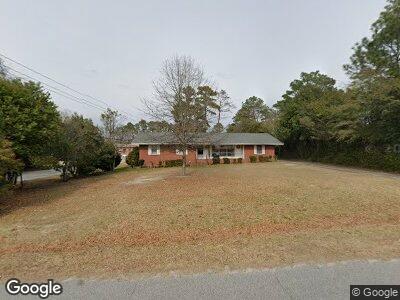
1221 Courtland Ave Florence, SC 29505
Highland Park NeighborhoodEstimated Value: $170,539 - $220,000
3
Beds
2
Baths
1,592
Sq Ft
$121/Sq Ft
Est. Value
About This Home
This home is located at 1221 Courtland Ave, Florence, SC 29505 and is currently estimated at $192,135, approximately $120 per square foot. 1221 Courtland Ave is a home located in Florence County with nearby schools including Briggs Elementary School, Southside Middle School, and South Florence High School.
Ownership History
Date
Name
Owned For
Owner Type
Purchase Details
Closed on
Dec 12, 2013
Sold by
Garrison Amy and Stalker Emily Garrison
Bought by
Garrison Daniel G and Garrison Debra K
Current Estimated Value
Home Financials for this Owner
Home Financials are based on the most recent Mortgage that was taken out on this home.
Original Mortgage
$71,200
Outstanding Balance
$23,538
Interest Rate
4.19%
Mortgage Type
New Conventional
Estimated Equity
$169,475
Purchase Details
Closed on
Nov 15, 2011
Sold by
Estate Of Ardith Clara H Garrison
Bought by
Garrison Daniel and Garrison Nancy
Purchase Details
Closed on
Aug 16, 2011
Sold by
Estate Of Ardith Clara H Garrison
Bought by
Garrison Daniel and Garrison Nancy
Purchase Details
Closed on
Mar 21, 2002
Sold by
Hart Richard E and Hart Sandra T
Bought by
Hud
Create a Home Valuation Report for This Property
The Home Valuation Report is an in-depth analysis detailing your home's value as well as a comparison with similar homes in the area
Home Values in the Area
Average Home Value in this Area
Purchase History
| Date | Buyer | Sale Price | Title Company |
|---|---|---|---|
| Garrison Daniel G | $89,000 | -- | |
| Garrison Daniel | -- | -- | |
| Garrison Daniel | -- | -- | |
| Hud | $62,000 | -- |
Source: Public Records
Mortgage History
| Date | Status | Borrower | Loan Amount |
|---|---|---|---|
| Open | Garrison Daniel G | $71,200 |
Source: Public Records
Tax History Compared to Growth
Tax History
| Year | Tax Paid | Tax Assessment Tax Assessment Total Assessment is a certain percentage of the fair market value that is determined by local assessors to be the total taxable value of land and additions on the property. | Land | Improvement |
|---|---|---|---|---|
| 2023 | $1,809 | $3,382 | $880 | $2,502 |
| 2022 | $1,839 | $3,382 | $880 | $2,502 |
| 2021 | $1,866 | $5,070 | $0 | $0 |
| 2020 | $1,794 | $5,070 | $0 | $0 |
| 2019 | $1,766 | $5,070 | $0 | $0 |
| 2018 | $1,693 | $5,070 | $0 | $0 |
| 2017 | $1,660 | $5,070 | $0 | $0 |
| 2016 | $1,620 | $5,070 | $0 | $0 |
| 2015 | $1,856 | $5,810 | $0 | $0 |
| 2014 | $1,772 | $3,873 | $880 | $2,993 |
Source: Public Records
Map
Nearby Homes
- 1212 Melrose Ave
- 1714 2nd Loop Rd
- 1392 2nd Loop Rd
- 1305 W Brookshire Ct
- 1175 Berkley Ave
- 1406 Poinsett Dr
- 1507 Hampton Dr
- 1017 Wrenwood Rd
- 1454 Dorchester Rd
- 1815 Hampton Dr
- 1770 Woods Dr
- 954 Clarendon Ave
- 709 Hampton Ct
- 711 Manchester Ave
- 1497 Gardener Rd
- 1612 Damon Dr
- 1167 Sherwood Dr
- 1031 W Hill Dr
- 1024 Woodstone Dr
- 1801 Furman Dr