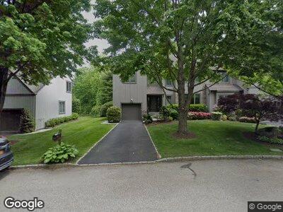
132 Woodbrook Rd White Plains, NY 10605
Haviland Manor NeighborhoodEstimated Value: $892,000 - $1,184,081
--
Bed
--
Bath
3,420
Sq Ft
$309/Sq Ft
Est. Value
About This Home
This home is located at 132 Woodbrook Rd, White Plains, NY 10605 and is currently estimated at $1,057,694, approximately $309 per square foot. 132 Woodbrook Rd is a home located in Westchester County with nearby schools including White Plains Middle School, White Plains Senior High School, and German International School New York.
Ownership History
Date
Name
Owned For
Owner Type
Purchase Details
Closed on
Dec 17, 2024
Sold by
Joann Brown Revocable Living Trust and Stern Lisa
Bought by
Joann Brown Revocable Living Trust and Brown
Current Estimated Value
Purchase Details
Closed on
Oct 21, 2024
Sold by
Brown Joann Huitt and Brown Joann
Bought by
Joann Brown Revocable Living Trust and Stern
Purchase Details
Closed on
Sep 19, 1995
Sold by
Toll Peppertree Lp
Bought by
Brown Joann Huitt
Create a Home Valuation Report for This Property
The Home Valuation Report is an in-depth analysis detailing your home's value as well as a comparison with similar homes in the area
Home Values in the Area
Average Home Value in this Area
Purchase History
| Date | Buyer | Sale Price | Title Company |
|---|---|---|---|
| Joann Brown Revocable Living Trust | -- | None Listed On Document | |
| Joann Brown Revocable Living Trust | -- | None Listed On Document | |
| Joann Brown Revocable Living Trust | -- | None Listed On Document | |
| Brown Joann Huitt | $356,773 | -- |
Source: Public Records
Tax History Compared to Growth
Tax History
| Year | Tax Paid | Tax Assessment Tax Assessment Total Assessment is a certain percentage of the fair market value that is determined by local assessors to be the total taxable value of land and additions on the property. | Land | Improvement |
|---|---|---|---|---|
| 2024 | $15,599 | $18,725 | $2,300 | $16,425 |
| 2023 | $2,654 | $18,725 | $2,300 | $16,425 |
| 2022 | $17,277 | $18,725 | $2,300 | $16,425 |
| 2021 | $17,273 | $18,725 | $2,300 | $16,425 |
| 2020 | $16,997 | $18,725 | $2,300 | $16,425 |
| 2019 | $19,341 | $18,725 | $2,300 | $16,425 |
| 2018 | $14,313 | $18,725 | $2,300 | $16,425 |
| 2017 | $0 | $18,725 | $2,300 | $16,425 |
| 2016 | $17,720 | $18,725 | $2,300 | $16,425 |
| 2015 | $2,612 | $18,725 | $2,300 | $16,425 |
| 2014 | $2,612 | $18,725 | $2,300 | $16,425 |
| 2013 | $2,612 | $18,725 | $2,300 | $16,425 |
Source: Public Records
Map
Nearby Homes
- 59 Kass Rd
- 65 Jennings Rd
- 90 Havilands Ln
- 95 Club Pointe Dr Unit 95
- 13 Baylor Cir
- 27 Homeside Ln
- 75 Kenilworth Rd
- 10 Richbell Rd
- 14 Richbell Rd
- 61 Brook Hills Cir
- 40 Polly Pk Rd
- 88 Brook Hills Cir
- 131 Barton Rd
- 400 Rosedale Ave
- 14 Wyndham Close
- 20 Colonial Rd
- 165 Polly Park Rd
- 162 Barton Rd
- 570 North St
- 31 Colonial Rd