

1346 Weide Way Anderson, CA 96007
Anderson City Center NeighborhoodEstimated payment $1,120/month
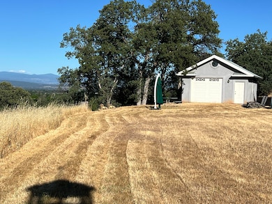
Highlights
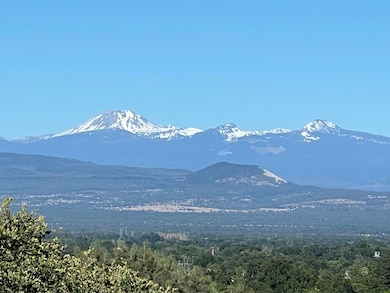
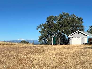
- Panoramic View
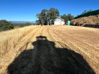
- Partially Fenced Property
- Level Lot
- 2.43 Acre Lot
About This Lot
Looking for one of the best views of Mt Shasta and Lassen Peak in the county? This property has it all, Underground Power to the site, Septic Installed, Well is in, and a garage ready for use. Build your View home on the edge of town with expansive views, a peaceful setting with plenty of privacy. What are you waiting for??
Property Details
Property Type
- Land
Est. Annual Taxes
- $731
Lot Details
- 2.43 Acre Lot
- Lot Dimensions are 363x349x322x357
- Partially Fenced Property
- Level Lot
- Zoning described as Anderson R-1-HS Low Density Residential Hillside
Property Views
- Panoramic
- Mountain
- Valley
Listing and Financial Details
- Assessor Parcel Number 202-700-022
Map
Home Values in the Area
Average Home Value in this Area
Tax History
| Year | Tax Paid | Tax Assessment Tax Assessment Total Assessment is a certain percentage of the fair market value that is determined by local assessors to be the total taxable value of land and additions on the property. | Land | Improvement |
|---|---|---|---|---|
| 2024 | $731 | $65,024 | $52,726 | $12,298 |
| 2023 | $731 | $63,750 | $51,693 | $12,057 |
| 2022 | $708 | $62,501 | $50,680 | $11,821 |
| 2021 | $701 | $61,277 | $49,687 | $11,590 |
| 2020 | $707 | $60,650 | $49,178 | $11,472 |
| 2019 | $677 | $59,462 | $48,214 | $11,248 |
| 2018 | $666 | $58,297 | $47,269 | $11,028 |
| 2017 | $668 | $57,155 | $46,343 | $10,812 |
| 2016 | $620 | $56,035 | $45,435 | $10,600 |
| 2015 | $622 | $55,194 | $44,753 | $10,441 |
| 2014 | $607 | $54,114 | $43,877 | $10,237 |
Property History
| Date | Event | Price | Change | Sq Ft Price |
|---|---|---|---|---|
| 06/05/2024 06/05/24 | For Sale | $189,900 | -- | -- |
Deed History
| Date | Type | Sale Price | Title Company |
|---|---|---|---|
| Grant Deed | $35,000 | Placer Title Company |
Mortgage History
| Date | Status | Loan Amount | Loan Type |
|---|---|---|---|
| Open | $30,000 | Seller Take Back |
Source: Shasta Association of REALTORS®
MLS Number: 24-2488
APN: 202-700-022-000
Disclaimer: Certain information contained herein is derived from information provided by parties other than Homes.com. All information provided is deemed reliable, but is not guaranteed to be accurate and should be independently verified.
![]() IDX information is provided exclusively for personal, non-commercial use, and may not be used for any purpose other than to identify prospective properties consumers may be interested in purchasing. Information is deemed reliable but not guaranteed.
IDX information is provided exclusively for personal, non-commercial use, and may not be used for any purpose other than to identify prospective properties consumers may be interested in purchasing. Information is deemed reliable but not guaranteed.
- 3525 Paul Dr
- 1480 1st St
- 1411 Diamond St
- 3241 Cory Ln
- 0 1st St
- 1535 Cordova St
- 1770 Brigman St
- 1711 Shasta St
- 3420 W Center St
- 6024 Hornbeck Ln
- 19482 Spring Gulch Rd
- 6040 Hornbeck Ln
- 3386 Lyndsey Ln
- 1730 Ferry St
- 5995 Bellevue Ln
- 3065 Silver St
- 3383 Nathan Dr
- 3612 Rush Landing
- 5 acres W Anderson Dr
- 2010 Frontier Trail
