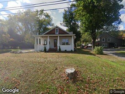
1348 River Rd Upper Black Eddy, PA 18972
Estimated Value: $256,000 - $426,000
2
Beds
1
Bath
1,152
Sq Ft
$303/Sq Ft
Est. Value
About This Home
This home is located at 1348 River Rd, Upper Black Eddy, PA 18972 and is currently estimated at $348,859, approximately $302 per square foot. 1348 River Rd is a home located in Bucks County with nearby schools including Durham Nockamixon Elementary School, Palisades Middle School, and Palisades High School.
Ownership History
Date
Name
Owned For
Owner Type
Purchase Details
Closed on
Apr 19, 2004
Sold by
Zambek Stanley T and Downer Jane
Bought by
Singley Scott
Current Estimated Value
Home Financials for this Owner
Home Financials are based on the most recent Mortgage that was taken out on this home.
Original Mortgage
$90,000
Interest Rate
8.15%
Mortgage Type
Stand Alone First
Purchase Details
Closed on
Mar 13, 1975
Bought by
Zambek Stanley T
Create a Home Valuation Report for This Property
The Home Valuation Report is an in-depth analysis detailing your home's value as well as a comparison with similar homes in the area
Home Values in the Area
Average Home Value in this Area
Purchase History
| Date | Buyer | Sale Price | Title Company |
|---|---|---|---|
| Zambek Stanley T | $37,500 | -- |
Source: Public Records
Mortgage History
| Date | Status | Borrower | Loan Amount |
|---|---|---|---|
| Open | Singley Scott | $170,000 | |
| Closed | Singley Scott | $60,000 | |
| Previous Owner | Singley Scott | $90,000 |
Source: Public Records
Tax History Compared to Growth
Tax History
| Year | Tax Paid | Tax Assessment Tax Assessment Total Assessment is a certain percentage of the fair market value that is determined by local assessors to be the total taxable value of land and additions on the property. | Land | Improvement |
|---|---|---|---|---|
| 2024 | $3,508 | $23,200 | $8,360 | $14,840 |
| 2023 | $3,461 | $23,200 | $8,360 | $14,840 |
| 2022 | $3,421 | $23,200 | $8,360 | $14,840 |
| 2021 | $3,398 | $23,200 | $8,360 | $14,840 |
| 2020 | $3,398 | $23,200 | $8,360 | $14,840 |
| 2019 | $3,358 | $23,200 | $8,360 | $14,840 |
| 2018 | $3,335 | $23,200 | $8,360 | $14,840 |
| 2017 | $3,281 | $23,200 | $8,360 | $14,840 |
| 2016 | $3,281 | $23,200 | $8,360 | $14,840 |
| 2015 | -- | $23,200 | $8,360 | $14,840 |
| 2014 | -- | $23,200 | $8,360 | $14,840 |
Source: Public Records
Map
Nearby Homes
- 1396 River Rd
- 1406 River Rd
- 1434 River Rd
- 538 Mil Ford-Frenchtown
- 164 Frenchtown Rd
- 3 Red Cliff Village Ln
- 1717 Bridge Ln
- 81 Fairview Ave
- 5 Field Rd
- 66 Fairview Ave
- 284 Milford Mount Pleasant Rd
- 67 Water St
- 1656 Chestnut Ridge Rd
- 311 Fawnwood Dr
- 1664 Chestnut Ridge Rd
- 169 York Rd
- 1764 River Rd
- 369 Stamets Rd
- 1827 Trails End Ln
- 29 Boulder Rd