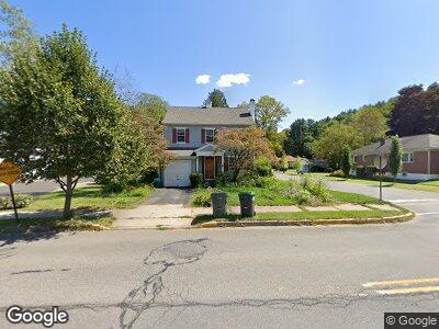
138 Broad St Stroudsburg, PA 18360
Estimated Value: $289,000 - $309,168
4
Beds
2
Baths
2,695
Sq Ft
$109/Sq Ft
Est. Value
About This Home
This home is located at 138 Broad St, Stroudsburg, PA 18360 and is currently estimated at $295,042, approximately $109 per square foot. 138 Broad St is a home located in Monroe County with nearby schools including Stroudsburg Junior High School, Stroudsburg High School, and Stroudsburg Seventh-day Adventist School.
Ownership History
Date
Name
Owned For
Owner Type
Purchase Details
Closed on
Jun 3, 2024
Sold by
Summers-Allen Saiglea
Bought by
Gasser Heather and Lewis Allen
Current Estimated Value
Purchase Details
Closed on
Mar 25, 2021
Sold by
Lively Clifford B and Summers Robin Lively
Bought by
Summers Allen Saiglea
Home Financials for this Owner
Home Financials are based on the most recent Mortgage that was taken out on this home.
Original Mortgage
$75,000
Interest Rate
2.8%
Mortgage Type
New Conventional
Purchase Details
Closed on
Sep 28, 2004
Bought by
Lively Clifford B
Create a Home Valuation Report for This Property
The Home Valuation Report is an in-depth analysis detailing your home's value as well as a comparison with similar homes in the area
Home Values in the Area
Average Home Value in this Area
Purchase History
| Date | Buyer | Sale Price | Title Company |
|---|---|---|---|
| Gasser Heather | $280,000 | Keystone Premier Settlement Se | |
| Summers Allen Saiglea | -- | Lighthouse Abstract Ltd | |
| Lively Clifford B | $194,000 | -- |
Source: Public Records
Mortgage History
| Date | Status | Borrower | Loan Amount |
|---|---|---|---|
| Previous Owner | Summers-Allen Saiglea | $11,510 | |
| Previous Owner | Summers-Allen Saiglea | $99,262 | |
| Previous Owner | Summers Allen Saiglea | $75,000 | |
| Previous Owner | Lively Clifford B | $134,500 | |
| Previous Owner | Lively Clifford B | $50,000 |
Source: Public Records
Tax History Compared to Growth
Tax History
| Year | Tax Paid | Tax Assessment Tax Assessment Total Assessment is a certain percentage of the fair market value that is determined by local assessors to be the total taxable value of land and additions on the property. | Land | Improvement |
|---|---|---|---|---|
| 2024 | $2,384 | $170,410 | $22,500 | $147,910 |
| 2023 | $2,111 | $170,410 | $22,500 | $147,910 |
| 2022 | $6,514 | $170,410 | $22,500 | $147,910 |
| 2021 | $6,225 | $170,410 | $22,500 | $147,910 |
| 2019 | $4,922 | $21,180 | $4,320 | $16,860 |
| 2018 | $4,853 | $21,180 | $4,320 | $16,860 |
| 2017 | $4,790 | $21,180 | $4,320 | $16,860 |
| 2016 | $1,331 | $21,180 | $4,320 | $16,860 |
| 2015 | -- | $21,180 | $4,320 | $16,860 |
| 2014 | -- | $21,180 | $4,320 | $16,860 |
Source: Public Records
Map
Nearby Homes
- 239 Stokes Ave
- Lot V8 Godfrey's Gate Rd
- 221 Huston Ave
- 230 Colbert St
- 0 Pennsylvania 191
- 3154 Godfrey Ridge Dr
- 507 Thomas St
- 607 Thomas St
- 305 N 7th St
- 28 Turtle Way
- 63 N 10th St
- 711 Fulmer Ave
- 704 Bangor Mountain Rd
- 844 Scott St
- 208 N 9th St
- 7102 Cherry Valley Rd
- 58 Village Dr
- 5 Village Cir Unit 1104
- 110 Kraemer Ave
- 75 Village Dr