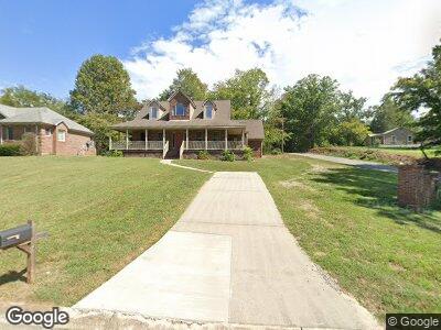
1405 Fox Chase Ct Cookeville, TN 38506
Seven NeighborhoodEstimated Value: $452,640 - $578,000
--
Bed
3
Baths
2,678
Sq Ft
$193/Sq Ft
Est. Value
About This Home
This home is located at 1405 Fox Chase Ct, Cookeville, TN 38506 and is currently estimated at $517,160, approximately $193 per square foot. 1405 Fox Chase Ct is a home located in Putnam County with nearby schools including Prescott South Elementary School, Cookeville High School, and Prescott South Middle School.
Ownership History
Date
Name
Owned For
Owner Type
Purchase Details
Closed on
Apr 15, 1997
Sold by
Milford Mountain Assoc
Bought by
Driller J E
Current Estimated Value
Home Financials for this Owner
Home Financials are based on the most recent Mortgage that was taken out on this home.
Original Mortgage
$120,000
Interest Rate
7.85%
Purchase Details
Closed on
Sep 8, 1995
Bought by
Millford Mountain Assoc %John R Wieland
Create a Home Valuation Report for This Property
The Home Valuation Report is an in-depth analysis detailing your home's value as well as a comparison with similar homes in the area
Home Values in the Area
Average Home Value in this Area
Purchase History
| Date | Buyer | Sale Price | Title Company |
|---|---|---|---|
| Driller J E | -- | -- | |
| Millford Mountain Assoc %John R Wieland | $21,000 | -- |
Source: Public Records
Mortgage History
| Date | Status | Borrower | Loan Amount |
|---|---|---|---|
| Open | Driller J E & Sandra | $175,000 | |
| Closed | Millford Mountain Assoc %John R Wieland | $120,000 |
Source: Public Records
Tax History Compared to Growth
Tax History
| Year | Tax Paid | Tax Assessment Tax Assessment Total Assessment is a certain percentage of the fair market value that is determined by local assessors to be the total taxable value of land and additions on the property. | Land | Improvement |
|---|---|---|---|---|
| 2024 | $2,930 | $81,825 | $8,750 | $73,075 |
| 2023 | $2,930 | $81,825 | $8,750 | $73,075 |
| 2022 | $2,694 | $81,825 | $8,750 | $73,075 |
| 2021 | $2,694 | $81,825 | $8,750 | $73,075 |
| 2020 | $2,487 | $81,825 | $8,750 | $73,075 |
| 2019 | $2,487 | $63,500 | $8,750 | $54,750 |
| 2018 | $2,267 | $63,500 | $8,750 | $54,750 |
| 2017 | $2,267 | $63,500 | $8,750 | $54,750 |
| 2016 | $2,267 | $63,500 | $8,750 | $54,750 |
| 2015 | $2,267 | $63,500 | $8,750 | $54,750 |
| 2014 | $2,348 | $63,375 | $0 | $0 |
Source: Public Records
Map
Nearby Homes
- 120 Essex Rd
- 1441 Bunker Hill Rd
- 20 Cabot Ln
- 1466 Bunker Hill Rd
- 1380 Pilot Dr
- 0 S Jefferson Ave
- 1176 S Jefferson Ave
- 20 Battlefield Rd
- 1719 Heathrow Dr
- 236 Stratford Dr
- 1740 Bunker Hill Rd
- Lot 20 Julia Dr
- 408 Hillary Ct
- 1755 Bunker Hill Rd
- 243 Stratford Dr
- 1690 White Rd
- 1656 Flintwood Ave
- 1556 Flintwood Ave