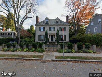
148 Brattle St Cambridge, MA 02138
West Cambridge NeighborhoodEstimated Value: $5,648,000 - $6,988,000
5
Beds
7
Baths
3,961
Sq Ft
$1,594/Sq Ft
Est. Value
About This Home
This home is located at 148 Brattle St, Cambridge, MA 02138 and is currently estimated at $6,313,890, approximately $1,594 per square foot. 148 Brattle St is a home located in Middlesex County with nearby schools including St Peter School, Cambridge Montessori School, and Buckingham Browne & Nichols School.
Ownership History
Date
Name
Owned For
Owner Type
Purchase Details
Closed on
Dec 1, 2021
Sold by
Coolidge Lindsay L and Coolidge Charles A
Bought by
148 Brattle Street Rt
Current Estimated Value
Purchase Details
Closed on
Jul 8, 2003
Sold by
Oliver-Jolliffe Ruth and Morley Ruth Fo
Bought by
Coolidge Charles A and Coolidge Lindsay L
Home Financials for this Owner
Home Financials are based on the most recent Mortgage that was taken out on this home.
Original Mortgage
$1,000,000
Interest Rate
5.46%
Mortgage Type
Purchase Money Mortgage
Create a Home Valuation Report for This Property
The Home Valuation Report is an in-depth analysis detailing your home's value as well as a comparison with similar homes in the area
Home Values in the Area
Average Home Value in this Area
Purchase History
| Date | Buyer | Sale Price | Title Company |
|---|---|---|---|
| 148 Brattle Street Rt | -- | None Available | |
| Coolidge Charles A | $2,875,000 | -- |
Source: Public Records
Mortgage History
| Date | Status | Borrower | Loan Amount |
|---|---|---|---|
| Previous Owner | Coolidge 3Rd Charles A | $417,000 | |
| Previous Owner | Morely Daniel F | $417,000 | |
| Previous Owner | Coolidge Charles A | $1,000,000 | |
| Previous Owner | Morely Daniel F | $100,000 | |
| Previous Owner | Morely Daniel F | $130,000 |
Source: Public Records
Tax History Compared to Growth
Tax History
| Year | Tax Paid | Tax Assessment Tax Assessment Total Assessment is a certain percentage of the fair market value that is determined by local assessors to be the total taxable value of land and additions on the property. | Land | Improvement |
|---|---|---|---|---|
| 2025 | $33,245 | $5,235,500 | $2,753,500 | $2,482,000 |
| 2024 | $29,987 | $5,065,400 | $2,731,500 | $2,333,900 |
| 2023 | $27,936 | $4,767,200 | $2,720,400 | $2,046,800 |
| 2022 | $25,524 | $4,311,500 | $2,494,800 | $1,816,700 |
| 2021 | $24,359 | $4,164,000 | $2,448,100 | $1,715,900 |
| 2020 | $22,821 | $3,968,900 | $2,342,900 | $1,626,000 |
| 2019 | $20,678 | $3,481,100 | $1,973,600 | $1,507,500 |
| 2018 | $21,523 | $3,421,800 | $1,963,400 | $1,458,400 |
| 2017 | $21,134 | $3,256,400 | $1,872,300 | $1,384,100 |
| 2016 | $20,419 | $2,921,200 | $1,619,300 | $1,301,900 |
| 2015 | $20,997 | $2,685,100 | $1,518,100 | $1,167,000 |
| 2014 | $22,038 | $2,629,800 | $1,477,700 | $1,152,100 |
Source: Public Records
Map
Nearby Homes
- 2 Kenway St
- 20 Maynard Place
- 57 Brewster St
- 9 Gibson St Unit 9
- 7 Gibson St Unit 7
- 11 Brown St
- 1010 Memorial Dr Unit 6G
- 172 Brattle St
- 8 Traill St
- 15 Traill St
- 54 Concord Ave Unit 203
- 17 Berkeley St
- 22 Concord Ave Unit 10
- 20-22 Concord Ave Unit 7
- 29 Concord Ave Unit 608
- 55 Fayerweather St
- 14 Concord Ave Unit 416
- 14 Concord Ave Unit 422
- 52 Garden St Unit 49
- 52 Garden St Unit 4