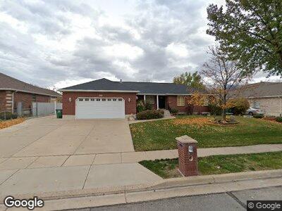
1596 Willow Dr Kaysville, UT 84037
West Kaysville NeighborhoodEstimated Value: $754,000 - $808,138
6
Beds
3
Baths
3,698
Sq Ft
$212/Sq Ft
Est. Value
About This Home
This home is located at 1596 Willow Dr, Kaysville, UT 84037 and is currently estimated at $784,785, approximately $212 per square foot. 1596 Willow Dr is a home located in Davis County with nearby schools including Kay's Creek Elementary School, Shoreline Junior High School, and Davis High School.
Ownership History
Date
Name
Owned For
Owner Type
Purchase Details
Closed on
Jan 31, 2024
Sold by
Bland David
Bought by
Peterson Greg D and Peterson Teresa Tingey
Current Estimated Value
Home Financials for this Owner
Home Financials are based on the most recent Mortgage that was taken out on this home.
Original Mortgage
$659,205
Outstanding Balance
$650,740
Interest Rate
6.61%
Mortgage Type
New Conventional
Estimated Equity
$134,045
Purchase Details
Closed on
Apr 13, 2022
Sold by
David Bland
Bought by
Bland David
Home Financials for this Owner
Home Financials are based on the most recent Mortgage that was taken out on this home.
Original Mortgage
$640,000
Interest Rate
4.72%
Mortgage Type
Construction
Purchase Details
Closed on
Jun 23, 2020
Sold by
Webster Mark and Webster Michelle
Bought by
Bland David and Bland Ashley
Purchase Details
Closed on
Jul 7, 2017
Sold by
Webster Kirk W and Webster Yolanda F
Bought by
Webster Marl and Webster Michelle
Home Financials for this Owner
Home Financials are based on the most recent Mortgage that was taken out on this home.
Original Mortgage
$360,324
Interest Rate
3.95%
Mortgage Type
VA
Purchase Details
Closed on
Aug 16, 1999
Sold by
Burningham Mark D and Burningham Belinda B
Bought by
Webster Kirk W and Webster Yolanda F
Home Financials for this Owner
Home Financials are based on the most recent Mortgage that was taken out on this home.
Original Mortgage
$191,200
Interest Rate
9.5%
Purchase Details
Closed on
Nov 7, 1996
Sold by
Ed Green Construction Inc
Bought by
Burningham Mark D and Burningham Belinda B
Home Financials for this Owner
Home Financials are based on the most recent Mortgage that was taken out on this home.
Original Mortgage
$141,000
Interest Rate
8.14%
Purchase Details
Closed on
May 7, 1996
Sold by
Green L Dale and Green Bette L
Bought by
Ed Green Construction Inc
Create a Home Valuation Report for This Property
The Home Valuation Report is an in-depth analysis detailing your home's value as well as a comparison with similar homes in the area
Home Values in the Area
Average Home Value in this Area
Purchase History
| Date | Buyer | Sale Price | Title Company |
|---|---|---|---|
| Peterson Greg D | -- | Investors Title | |
| Bland David | -- | None Listed On Document | |
| Bland David | -- | Us Title Company Of | |
| Webster Marl | -- | -- | |
| Webster Kirk W | -- | -- | |
| Webster Kirk W | -- | Us Title | |
| Burningham Mark D | -- | Security Title Company | |
| Ed Green Construction Inc | -- | Bonneville Title Company Inc |
Source: Public Records
Mortgage History
| Date | Status | Borrower | Loan Amount |
|---|---|---|---|
| Open | Peterson Greg D | $439,500 | |
| Open | Peterson Greg D | $659,205 | |
| Previous Owner | Bland David | $640,000 | |
| Previous Owner | Webster Marl | $360,324 | |
| Previous Owner | Webster Kirk W | $326,800 | |
| Previous Owner | Webster Kirk W | $326,650 | |
| Previous Owner | Webster Kirk W | $15,809 | |
| Previous Owner | Webster Kirk W | $335,716 | |
| Previous Owner | Webster Kirk W | $15,876 | |
| Previous Owner | Webster Kirk W | $191,200 | |
| Previous Owner | Burningham Mark D | $141,000 |
Source: Public Records
Tax History Compared to Growth
Tax History
| Year | Tax Paid | Tax Assessment Tax Assessment Total Assessment is a certain percentage of the fair market value that is determined by local assessors to be the total taxable value of land and additions on the property. | Land | Improvement |
|---|---|---|---|---|
| 2024 | $3,547 | $374,000 | $226,278 | $147,722 |
| 2023 | $3,556 | $664,000 | $393,336 | $270,664 |
| 2022 | $3,654 | $382,800 | $214,236 | $168,564 |
| 2021 | $3,407 | $535,000 | $262,614 | $272,386 |
| 2020 | $3,054 | $467,000 | $225,911 | $241,089 |
| 2019 | $2,930 | $440,000 | $220,305 | $219,695 |
| 2018 | $2,719 | $407,000 | $188,614 | $218,386 |
| 2016 | $2,680 | $210,870 | $90,059 | $120,811 |
| 2015 | $2,619 | $195,690 | $90,059 | $105,631 |
| 2014 | $2,441 | $185,677 | $69,099 | $116,578 |
| 2013 | -- | $178,792 | $56,059 | $122,733 |
Source: Public Records
Map
Nearby Homes
- 1910 W Walker Farm Dr
- 1932 W 200 N
- 1832 W Robins Way
- 417 N Hill Farms Ln
- 681 S Vance Dr
- 49 E 850 S
- 1534 Pheasant Meadow Dr
- 765 W Farming Way
- 2025 W Orchard Harvest Dr
- 1845 W Sherri Ln
- 51 N Gray Fox Cir
- 1041 S Hill Farms Dr
- 1040 Hill Farms Dr
- 34 S Preston St
- 688 S Angel St
- 37 S Preston St Unit 10
- 37 S Preston St Unit 2
- 165 S Farmhouse Cir
- 865 W 700 S
- 22 S Wildon Ct