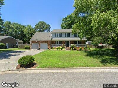
16 Windy Point Dr Poquoson, VA 23662
Poquoson West NeighborhoodEstimated Value: $492,589 - $577,000
3
Beds
3
Baths
2,613
Sq Ft
$198/Sq Ft
Est. Value
About This Home
This home is located at 16 Windy Point Dr, Poquoson, VA 23662 and is currently estimated at $516,647, approximately $197 per square foot. 16 Windy Point Dr is a home located in Poquoson City with nearby schools including Emmanuel Lutheran School, Living Word Academy, and Summit Christian Academy - Upper School.
Ownership History
Date
Name
Owned For
Owner Type
Purchase Details
Closed on
Dec 8, 2022
Sold by
Braun Robert H and Braun Anne H
Bought by
Braun Living Trust
Current Estimated Value
Purchase Details
Closed on
Aug 20, 2003
Sold by
Relocation Prudential
Bought by
Braun Robert
Home Financials for this Owner
Home Financials are based on the most recent Mortgage that was taken out on this home.
Original Mortgage
$195,000
Interest Rate
5.52%
Mortgage Type
New Conventional
Create a Home Valuation Report for This Property
The Home Valuation Report is an in-depth analysis detailing your home's value as well as a comparison with similar homes in the area
Home Values in the Area
Average Home Value in this Area
Purchase History
| Date | Buyer | Sale Price | Title Company |
|---|---|---|---|
| Braun Living Trust | -- | -- | |
| Braun Robert | $270,000 | -- |
Source: Public Records
Mortgage History
| Date | Status | Borrower | Loan Amount |
|---|---|---|---|
| Previous Owner | Braun Robert H | $294,400 | |
| Previous Owner | Braun Robert H | $294,975 | |
| Previous Owner | Braun Robert H | $163,235 | |
| Previous Owner | Braun Robert | $195,000 |
Source: Public Records
Tax History Compared to Growth
Tax History
| Year | Tax Paid | Tax Assessment Tax Assessment Total Assessment is a certain percentage of the fair market value that is determined by local assessors to be the total taxable value of land and additions on the property. | Land | Improvement |
|---|---|---|---|---|
| 2024 | $4,835 | $424,100 | $123,200 | $300,900 |
| 2023 | $4,708 | $424,100 | $123,200 | $300,900 |
| 2022 | $4,309 | $381,300 | $123,200 | $258,100 |
| 2021 | $4,309 | $381,300 | $123,200 | $258,100 |
| 2020 | $0 | $342,900 | $123,200 | $219,700 |
| 2019 | -- | $342,900 | $123,200 | $219,700 |
| 2018 | -- | $335,200 | $123,200 | $212,000 |
| 2017 | -- | $330,100 | $123,200 | $206,900 |
| 2016 | -- | $330,100 | $123,200 | $206,900 |
| 2015 | -- | $322,000 | $123,200 | $198,800 |
| 2013 | -- | $322,000 | $123,200 | $198,800 |
Source: Public Records
Map
Nearby Homes
- 97 Raptor Dr
- 95 Raptor Dr
- 93 Raptor Dr
- 147 Cedar Rd
- 182 Cedar Rd
- 132 Robert Bruce Rd
- 126 Robert Bruce Rd
- 118 Robert Bruce Rd
- 115 Robert Bruce Rd
- 119 Robert Bruce Rd
- 130 Robert Bruce Rd
- 113 Robert Bruce Rd
- 114 Robert Bruce Rd
- 5 Barrel Factory Ct
- 5 Canal Dr
- 6 Pinckney Ln
- 13 Jean Mar Dr
- 232 Cedar Rd
- 6 Canal Dr
- 6 Black Oak Ct