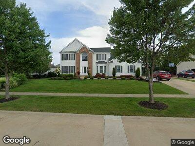
199 Kingston Dr Aurora, OH 44202
Estimated Value: $550,721 - $655,000
4
Beds
4
Baths
3,126
Sq Ft
$197/Sq Ft
Est. Value
About This Home
This home is located at 199 Kingston Dr, Aurora, OH 44202 and is currently estimated at $615,930, approximately $197 per square foot. 199 Kingston Dr is a home located in Portage County with nearby schools including Miller Elementary School, Leighton Elementary School, and Craddock/Miller Elementary School.
Ownership History
Date
Name
Owned For
Owner Type
Purchase Details
Closed on
Aug 12, 2010
Sold by
Trem Rocque and Raun Kara
Bought by
Malie Paul J and Malie Nicole J
Current Estimated Value
Home Financials for this Owner
Home Financials are based on the most recent Mortgage that was taken out on this home.
Original Mortgage
$261,600
Interest Rate
4.6%
Mortgage Type
New Conventional
Purchase Details
Closed on
Feb 13, 2003
Sold by
Krupinski David W and Krupinski Patricia K
Bought by
Trem Rocque and Raun Kara
Home Financials for this Owner
Home Financials are based on the most recent Mortgage that was taken out on this home.
Original Mortgage
$233,400
Interest Rate
5.94%
Create a Home Valuation Report for This Property
The Home Valuation Report is an in-depth analysis detailing your home's value as well as a comparison with similar homes in the area
Home Values in the Area
Average Home Value in this Area
Purchase History
| Date | Buyer | Sale Price | Title Company |
|---|---|---|---|
| Malie Paul J | $327,000 | Precision Title Agency Inc | |
| Trem Rocque | $291,800 | -- |
Source: Public Records
Mortgage History
| Date | Status | Borrower | Loan Amount |
|---|---|---|---|
| Open | Malie Paul J | $182,000 | |
| Closed | Malie Paul J | $256,500 | |
| Closed | Malie Paul J | $261,600 | |
| Open | State Route 88 Associates Llc | $1,750,000 | |
| Closed | Trem Rocque | $233,400 | |
| Previous Owner | Krupinski David W | $260,100 |
Source: Public Records
Tax History Compared to Growth
Tax History
| Year | Tax Paid | Tax Assessment Tax Assessment Total Assessment is a certain percentage of the fair market value that is determined by local assessors to be the total taxable value of land and additions on the property. | Land | Improvement |
|---|---|---|---|---|
| 2024 | $8,551 | $191,280 | $26,250 | $165,030 |
| 2023 | $8,160 | $148,610 | $26,250 | $122,360 |
| 2022 | $7,389 | $148,610 | $26,250 | $122,360 |
| 2021 | $7,431 | $148,610 | $26,250 | $122,360 |
| 2020 | $7,206 | $134,540 | $26,250 | $108,290 |
| 2019 | $7,264 | $134,540 | $26,250 | $108,290 |
| 2018 | $6,995 | $117,780 | $26,250 | $91,530 |
| 2017 | $6,995 | $117,780 | $26,250 | $91,530 |
| 2016 | $6,168 | $115,260 | $26,250 | $89,010 |
| 2015 | $6,342 | $115,260 | $26,250 | $89,010 |
| 2014 | $6,233 | $111,020 | $26,250 | $84,770 |
| 2013 | $6,194 | $111,020 | $26,250 | $84,770 |
Source: Public Records
Map
Nearby Homes
- 149 Chatham Dr
- 541 Fox Run Trail
- 985 Hawkin Ln
- 10 Greenbriar Dr
- 25 Pine Villa Trail Unit 11
- 655 Winslow Dr Unit 65
- 664 William Ct
- 457 E Pioneer Trail
- 90 Aurora Hudson Rd
- 461 Eldridge Rd
- 186 Eldridge Rd
- 700 Hampton Cir Unit 6
- 900 Hampton Cir Unit 2
- 963 Meadowlark Cir Unit 23K
- 230 Birchbark Trail
- 502-8 Overlook Dr
- 312 Equestra S
- 415-48 Honeysuckle Path
- 503-19 Concord Downs Ln
- 706-39 Claridge Ln