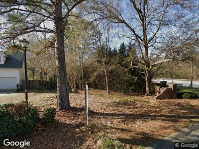
204 Aston Ln Lexington, SC 29072
Estimated Value: $13,659 - $295,000
--
Bed
--
Bath
--
Sq Ft
9,148
Sq Ft Lot
About This Home
This home is located at 204 Aston Ln, Lexington, SC 29072 and is currently estimated at $114,665. 204 Aston Ln is a home located in Lexington County with nearby schools including Midway Elementary School, River Bluff High School, and American Leadership Academy South Carolina-Lexington Campus.
Ownership History
Date
Name
Owned For
Owner Type
Purchase Details
Closed on
Jun 7, 2023
Sold by
King Donald Parker
Bought by
Soto Sergio
Current Estimated Value
Purchase Details
Closed on
May 8, 2023
Sold by
Wirth James
Bought by
King Donald Parker and King Jennifer Halleman
Purchase Details
Closed on
Apr 12, 2023
Sold by
King Donald Parker
Bought by
Wirth James and Wirth James A
Purchase Details
Closed on
Jun 11, 2021
Sold by
Wirth James and Wirth Brenda
Bought by
King Donald Parker and King Jennifer Halleman
Purchase Details
Closed on
Aug 24, 2020
Sold by
Lexington County
Bought by
Wirth James and Wirth Brendan
Purchase Details
Closed on
Jun 3, 2016
Sold by
Mungo Co Inc
Bought by
Trinh Vincent
Purchase Details
Closed on
Aug 28, 2014
Sold by
The Mungo Company Inc
Bought by
Pine Lake Group Llc
Create a Home Valuation Report for This Property
The Home Valuation Report is an in-depth analysis detailing your home's value as well as a comparison with similar homes in the area
Home Values in the Area
Average Home Value in this Area
Purchase History
| Date | Buyer | Sale Price | Title Company |
|---|---|---|---|
| Soto Sergio | $13,000 | None Listed On Document | |
| King Donald Parker | -- | None Listed On Document | |
| Wirth James | -- | None Listed On Document | |
| King Donald Parker | $10,000 | None Available | |
| Wirth James | $1,884 | None Listed On Document | |
| Trinh Vincent | $2,600 | None Available | |
| Pine Lake Group Llc | $1,505 | -- |
Source: Public Records
Tax History Compared to Growth
Tax History
| Year | Tax Paid | Tax Assessment Tax Assessment Total Assessment is a certain percentage of the fair market value that is determined by local assessors to be the total taxable value of land and additions on the property. | Land | Improvement |
|---|---|---|---|---|
| 2024 | $387 | $780 | $780 | $0 |
| 2023 | $387 | $600 | $600 | $0 |
| 2022 | $286 | $600 | $600 | $0 |
| 2020 | $993 | $2,070 | $2,070 | $0 |
| 2019 | $919 | $1,800 | $1,800 | $0 |
| 2018 | $886 | $1,800 | $1,800 | $0 |
| 2017 | $871 | $1,800 | $1,800 | $0 |
| 2016 | $844 | $1,800 | $1,800 | $0 |
| 2014 | $722 | $1,656 | $1,656 | $0 |
| 2013 | -- | $1,660 | $1,660 | $0 |
Source: Public Records
Map
Nearby Homes
- 733 Bentley Dr
- 835 Whitney Ln
- 796 Parkhurst Ln
- 205 Armanda Ct
- 767 Parkhurst Ln
- 236 Carriage Hill Ct
- 838 Bentley Dr
- 113 Silverstone Rd
- 407 Dorchester Ct
- 128 Hunters Ridge Dr
- 136 Hunters Ridge Dr
- 735 Beckley Ct
- 141 Cherokee Pond Ct
- 472 Forest Edge Trail
- 464 Forest Edge Trail
- 349 Saddlebrooke Cir
- 456 Forest Edge Trail
- 316 Cherokee Pond Trail
- 452 Forest Edge Trail
- 448 Forest Edge Trail
