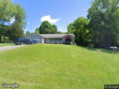
21031 Marianne Dr Abingdon, VA 24211
Estimated Value: $427,000 - $473,365
3
Beds
2
Baths
1,896
Sq Ft
$243/Sq Ft
Est. Value
About This Home
This home is located at 21031 Marianne Dr, Abingdon, VA 24211 and is currently estimated at $460,841, approximately $243 per square foot. 21031 Marianne Dr is a home located in Washington County with nearby schools including Watauga Elementary School, E.B. Stanley Middle School, and Abingdon High School.
Ownership History
Date
Name
Owned For
Owner Type
Purchase Details
Closed on
Mar 20, 2024
Sold by
Hayton Stacy Allen and Hayton Katherine Ann
Bought by
Holt Russell Maurice and Gillespie Holt Martha
Current Estimated Value
Home Financials for this Owner
Home Financials are based on the most recent Mortgage that was taken out on this home.
Original Mortgage
$446,500
Outstanding Balance
$441,640
Interest Rate
6.64%
Mortgage Type
New Conventional
Estimated Equity
$19,201
Create a Home Valuation Report for This Property
The Home Valuation Report is an in-depth analysis detailing your home's value as well as a comparison with similar homes in the area
Home Values in the Area
Average Home Value in this Area
Purchase History
| Date | Buyer | Sale Price | Title Company |
|---|---|---|---|
| Holt Russell Maurice | $470,000 | None Listed On Document |
Source: Public Records
Mortgage History
| Date | Status | Borrower | Loan Amount |
|---|---|---|---|
| Open | Holt Russell Maurice | $446,500 | |
| Previous Owner | Hayton Stacy A | $220,000 | |
| Previous Owner | Hayton Stacy A | $205,000 | |
| Previous Owner | Lopez Jose Marco | $202,400 |
Source: Public Records
Tax History Compared to Growth
Tax History
| Year | Tax Paid | Tax Assessment Tax Assessment Total Assessment is a certain percentage of the fair market value that is determined by local assessors to be the total taxable value of land and additions on the property. | Land | Improvement |
|---|---|---|---|---|
| 2024 | $1,289 | $214,900 | $40,000 | $174,900 |
| 2023 | $1,289 | $214,900 | $40,000 | $174,900 |
| 2022 | $1,289 | $214,900 | $40,000 | $174,900 |
| 2021 | $1,289 | $214,900 | $40,000 | $174,900 |
| 2019 | $1,282 | $203,500 | $40,000 | $163,500 |
| 2018 | $1,282 | $203,500 | $40,000 | $163,500 |
| 2017 | $1,282 | $203,500 | $40,000 | $163,500 |
| 2016 | $1,157 | $183,700 | $40,000 | $143,700 |
| 2015 | $1,157 | $183,700 | $40,000 | $143,700 |
| 2014 | $1,157 | $183,700 | $40,000 | $143,700 |
Source: Public Records
Map
Nearby Homes
- TBD Preston Place Dr
- 25538 Cornelius Dr
- Lot 46 Tbd Preston Place Dr
- 20268 Heron Cir
- TBD Lakeshore Dr
- Lot 13 Lakeshore Dr
- 21127 Garden Path Ln
- TRACT 22 Capri Ave
- 23001 Moonshine Dr
- 0 Lake Pointe Drive Lot 7 Unit 73389
- 0 Lake Pointe Drive Lot 7 Unit 9905699
- 0 Lake Pointe Drive Lot 8 Unit 73390
- 0 Lake Pointe Drive Lot 8 Unit 9905700
- 18207 Macedonia Rd
- 18128 Brekenridge Ct
- 0 Lake Pointe Drive Lot 9 Unit 73391
- 0 Lake Pointe Drive Lot 9 Unit 9905701
- 0 Lake Bend Court Lot 33 Unit 73400
- 0 Lake Bend Court Lot 33 Unit 9905712
- 0 Lake Bend Court Lot 31 Unit 73398