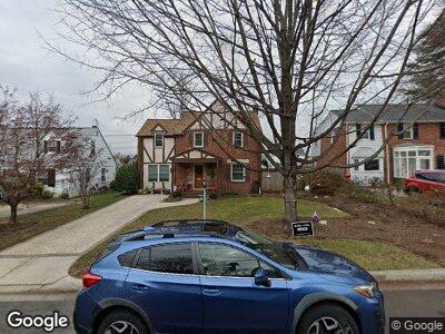
219 Normandy Dr Silver Spring, MD 20901
Indian Spring NeighborhoodEstimated Value: $704,051 - $792,000
4
Beds
2
Baths
1,764
Sq Ft
$428/Sq Ft
Est. Value
About This Home
This home is located at 219 Normandy Dr, Silver Spring, MD 20901 and is currently estimated at $755,763, approximately $428 per square foot. 219 Normandy Dr is a home located in Montgomery County with nearby schools including Highland View Elementary School, Silver Spring International Middle School, and Northwood High School.
Ownership History
Date
Name
Owned For
Owner Type
Purchase Details
Closed on
Aug 5, 2009
Sold by
Greenstein Gail E
Bought by
Suilebhan Gwydion T and Suilebhan Maura A
Current Estimated Value
Home Financials for this Owner
Home Financials are based on the most recent Mortgage that was taken out on this home.
Original Mortgage
$228,000
Interest Rate
5.43%
Mortgage Type
Purchase Money Mortgage
Purchase Details
Closed on
Nov 24, 2004
Sold by
Lewis Herman L and Lewis J
Bought by
Greenstein Gail E
Create a Home Valuation Report for This Property
The Home Valuation Report is an in-depth analysis detailing your home's value as well as a comparison with similar homes in the area
Home Values in the Area
Average Home Value in this Area
Purchase History
| Date | Buyer | Sale Price | Title Company |
|---|---|---|---|
| Suilebhan Gwydion T | $471,000 | -- | |
| Greenstein Gail E | $450,000 | -- | |
| Greenstein Gail E | $450,000 | -- |
Source: Public Records
Mortgage History
| Date | Status | Borrower | Loan Amount |
|---|---|---|---|
| Open | Suilebhan Gwydion T | $220,200 | |
| Closed | Suilebhan Gwydion T | $228,000 |
Source: Public Records
Tax History Compared to Growth
Tax History
| Year | Tax Paid | Tax Assessment Tax Assessment Total Assessment is a certain percentage of the fair market value that is determined by local assessors to be the total taxable value of land and additions on the property. | Land | Improvement |
|---|---|---|---|---|
| 2024 | $7,334 | $573,600 | $252,600 | $321,000 |
| 2023 | $6,483 | $561,733 | $0 | $0 |
| 2022 | $6,029 | $549,867 | $0 | $0 |
| 2021 | $5,535 | $538,000 | $252,600 | $285,400 |
| 2020 | $5,535 | $514,200 | $0 | $0 |
| 2019 | $5,236 | $490,400 | $0 | $0 |
| 2018 | $4,952 | $466,600 | $206,300 | $260,300 |
| 2017 | $4,893 | $454,067 | $0 | $0 |
| 2016 | $4,304 | $441,533 | $0 | $0 |
| 2015 | $4,304 | $429,000 | $0 | $0 |
| 2014 | $4,304 | $427,700 | $0 | $0 |
Source: Public Records
Map
Nearby Homes
- 9704 Hastings Dr
- 9707 Fairway Ave
- 201 Franklin Ave
- 9704 Lorain Ave
- 9906 Rogart Rd
- 9202 Worth Ave
- 9901 Markham St
- 122 Hamilton Ave
- 9602 Garwood St
- 9238 Three Oaks Dr
- 9226 Three Oaks Dr
- 3 Melbourne Ave
- 9201 Three Oaks Dr
- 9123 Eton Rd
- 9411 Garwood St
- 10004 Kinross Ave
- 9307 Biltmore Dr
- 10108 Kinross Ave
- 411 Pershing Dr
- 9138 Eton Rd