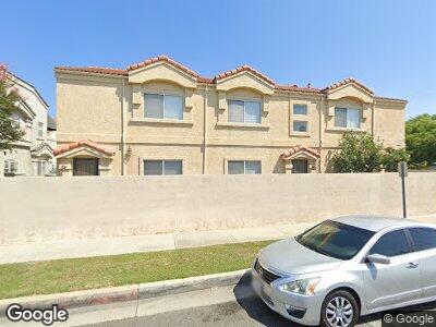
22027 Hawaiian Ave Unit D Hawaiian Gardens, CA 90716
Estimated Value: $637,112 - $714,000
3
Beds
3
Baths
1,301
Sq Ft
$517/Sq Ft
Est. Value
About This Home
This home is located at 22027 Hawaiian Ave Unit D, Hawaiian Gardens, CA 90716 and is currently estimated at $673,028, approximately $517 per square foot. 22027 Hawaiian Ave Unit D is a home located in Los Angeles County with nearby schools including Hawaiian Elementary School, Fedde (Pharis F.) Middle School, and Artesia High School.
Ownership History
Date
Name
Owned For
Owner Type
Purchase Details
Closed on
Oct 29, 2002
Sold by
Chiao Mei Development
Bought by
Park Esther H
Current Estimated Value
Home Financials for this Owner
Home Financials are based on the most recent Mortgage that was taken out on this home.
Original Mortgage
$174,400
Interest Rate
5.95%
Create a Home Valuation Report for This Property
The Home Valuation Report is an in-depth analysis detailing your home's value as well as a comparison with similar homes in the area
Home Values in the Area
Average Home Value in this Area
Purchase History
| Date | Buyer | Sale Price | Title Company |
|---|---|---|---|
| Park Esther H | $218,000 | Fidelity National Title Co |
Source: Public Records
Mortgage History
| Date | Status | Borrower | Loan Amount |
|---|---|---|---|
| Open | Park Esther H | $274,000 | |
| Closed | Park Esther H | $311,250 | |
| Closed | Park Esther H | $174,400 |
Source: Public Records
Tax History Compared to Growth
Tax History
| Year | Tax Paid | Tax Assessment Tax Assessment Total Assessment is a certain percentage of the fair market value that is determined by local assessors to be the total taxable value of land and additions on the property. | Land | Improvement |
|---|---|---|---|---|
| 2024 | $4,004 | $309,525 | $92,285 | $217,240 |
| 2023 | $3,879 | $303,457 | $90,476 | $212,981 |
| 2022 | $3,820 | $297,507 | $88,702 | $208,805 |
| 2021 | $3,730 | $291,674 | $86,963 | $204,711 |
| 2019 | $3,646 | $283,025 | $84,385 | $198,640 |
| 2018 | $3,396 | $277,477 | $82,731 | $194,746 |
| 2016 | $3,258 | $266,704 | $79,519 | $187,185 |
| 2015 | $3,219 | $262,699 | $78,325 | $184,374 |
| 2014 | $3,161 | $257,554 | $76,791 | $180,763 |
Source: Public Records
Map
Nearby Homes
- 21968 Belshire Ave
- 12550 Carson St Unit 70
- 12550 Carson St Unit 21
- 12550 Carson St Unit 124
- 12550 Carson St Unit 113
- 12550 Carson St Unit 20
- 21834 Belshire Ave Unit 2
- 8150 E Woodson St
- 8381 E Blithedale St
- 22121 Ibex Ave
- 22209 Ibex Ave
- 9080 Bloomfield St Unit 79
- 4162 Dover Cir
- 9080 Bloomfield Ave Unit 213
- 9080 Bloomfield Ave Unit 212
- 9080 Bloomfield Ave Unit 157
- 9080 Bloomfield Ave Unit 11
- 9080 Bloomfield Ave Unit 192
- 9080 Bloomfield Ave Unit 193
- 9080 Bloomfield Ave Unit 44