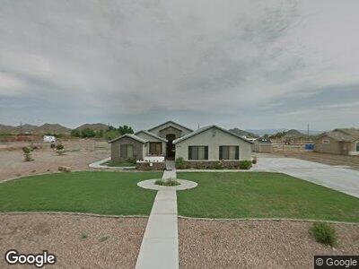
2296 W Skyline Ln San Tan Valley, AZ 85144
San Tan Mountain NeighborhoodEstimated Value: $654,000 - $703,000
5
Beds
3
Baths
2,247
Sq Ft
$303/Sq Ft
Est. Value
About This Home
This home is located at 2296 W Skyline Ln, San Tan Valley, AZ 85144 and is currently estimated at $680,581, approximately $302 per square foot. 2296 W Skyline Ln is a home located in Pinal County.
Ownership History
Date
Name
Owned For
Owner Type
Purchase Details
Closed on
Apr 7, 2009
Sold by
Fannie Mae
Bought by
Lacks Mark and Lacks Laurie
Current Estimated Value
Purchase Details
Closed on
Feb 11, 2009
Sold by
Cummard Stephen P and Cummard Crystal A
Bought by
Federal National Mortgage Association
Purchase Details
Closed on
Sep 26, 2005
Sold by
Cummard Stephen P
Bought by
Cummard Stephen P and Cummard Crystal A
Purchase Details
Closed on
Apr 13, 2004
Sold by
Ridgeback Llc
Bought by
Summard Stephen P and Cummard Crystal A
Home Financials for this Owner
Home Financials are based on the most recent Mortgage that was taken out on this home.
Original Mortgage
$40,000
Interest Rate
6.27%
Mortgage Type
New Conventional
Create a Home Valuation Report for This Property
The Home Valuation Report is an in-depth analysis detailing your home's value as well as a comparison with similar homes in the area
Home Values in the Area
Average Home Value in this Area
Purchase History
| Date | Buyer | Sale Price | Title Company |
|---|---|---|---|
| Lacks Mark | $190,000 | Lawyers Title Of Arizona Inc | |
| Federal National Mortgage Association | $300,070 | Great American Title Agency | |
| Cummard Stephen P | -- | -- | |
| Cummard Stephen P | -- | Capital Title Agency Inc | |
| Summard Stephen P | $56,331 | Capital Title Agency Inc |
Source: Public Records
Mortgage History
| Date | Status | Borrower | Loan Amount |
|---|---|---|---|
| Open | Lacks Mark | $226,800 | |
| Closed | Lacks Mark | $208,250 | |
| Closed | Lacks Mark | $190,200 | |
| Closed | Lacks Mark | $150,000 | |
| Previous Owner | Cummard Stephen P | $280,000 | |
| Previous Owner | Cummard Stephen P | $187,200 | |
| Previous Owner | Summard Stephen P | $40,000 |
Source: Public Records
Tax History Compared to Growth
Tax History
| Year | Tax Paid | Tax Assessment Tax Assessment Total Assessment is a certain percentage of the fair market value that is determined by local assessors to be the total taxable value of land and additions on the property. | Land | Improvement |
|---|---|---|---|---|
| 2025 | $1,794 | $57,121 | -- | -- |
| 2024 | $1,769 | $62,134 | -- | -- |
| 2023 | $1,799 | $50,272 | $0 | $0 |
| 2022 | $1,769 | $25,720 | $4,000 | $21,720 |
| 2021 | $1,966 | $23,543 | $0 | $0 |
| 2020 | $1,769 | $23,122 | $0 | $0 |
| 2019 | $1,771 | $21,180 | $0 | $0 |
| 2018 | $1,696 | $19,443 | $0 | $0 |
| 2017 | $1,593 | $16,673 | $0 | $0 |
| 2016 | $1,617 | $16,591 | $4,000 | $12,591 |
| 2014 | $1,425 | $12,704 | $3,825 | $8,879 |
Source: Public Records
Map
Nearby Homes
- 2659 W Bonnie Ln Unit 155C
- 0 W Adobe Dam Rd Unit 6770112
- 29252 N Bryce Trail Unit 2
- 5052 W Adobe Dam Rd
- 29967 N Sandridge Dr
- 28296 Wakefield Rd Unit 19
- 29204 N Bryce Trail
- 2861 W Bonnie Ln Unit 156C
- 2152 W Ivar Rd Unit 127
- 29972 N Bryce Trail
- 2249 W Daniel Rd
- 1550 W Adobe Dam Dr
- 30150 N Bryce Trail
- 1421 W Rylie Ct
- 28847 N Royce Rd
- 28821 N Ashbrook Ln
- - Bryce Trail
- 0000 S Marchant Trace
- 3340 W Mako Rd Unit 1
- 1116 W Stellar Place