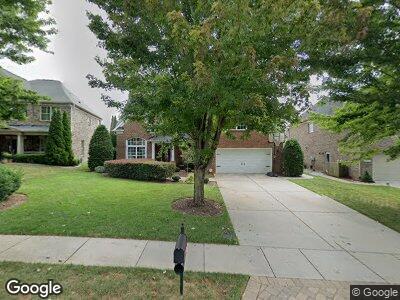
2313 Barrington Ridge Dr Waxhaw, NC 28173
Barrington NeighborhoodEstimated Value: $873,000 - $970,000
4
Beds
4
Baths
3,963
Sq Ft
$232/Sq Ft
Est. Value
About This Home
This home is located at 2313 Barrington Ridge Dr, Waxhaw, NC 28173 and is currently estimated at $919,291, approximately $231 per square foot. 2313 Barrington Ridge Dr is a home located in Union County with nearby schools including Sandy Ridge Elementary School, Marvin Ridge Middle School, and Marvin Ridge High School.
Ownership History
Date
Name
Owned For
Owner Type
Purchase Details
Closed on
Jan 21, 2014
Sold by
Blevins Martin Jared and Blevins Martin Katheryne
Bought by
Harrington Sean and Harrington Nicolle
Current Estimated Value
Home Financials for this Owner
Home Financials are based on the most recent Mortgage that was taken out on this home.
Original Mortgage
$342,000
Interest Rate
4.43%
Mortgage Type
New Conventional
Purchase Details
Closed on
May 1, 2009
Sold by
Shea Homes Llc
Bought by
Martin Jared and Blevins Katheryne
Home Financials for this Owner
Home Financials are based on the most recent Mortgage that was taken out on this home.
Original Mortgage
$359,100
Interest Rate
4.86%
Mortgage Type
Unknown
Create a Home Valuation Report for This Property
The Home Valuation Report is an in-depth analysis detailing your home's value as well as a comparison with similar homes in the area
Home Values in the Area
Average Home Value in this Area
Purchase History
| Date | Buyer | Sale Price | Title Company |
|---|---|---|---|
| Harrington Sean | $392,000 | Chicago Title Insurance Co | |
| Martin Jared | $384,500 | None Available |
Source: Public Records
Mortgage History
| Date | Status | Borrower | Loan Amount |
|---|---|---|---|
| Open | Harrington Sean | $320,000 | |
| Closed | Harrington Sean | $333,400 | |
| Closed | Harrington Sean | $343,250 | |
| Closed | Harrington Sean | $342,000 | |
| Previous Owner | Martin Jared | $359,100 |
Source: Public Records
Tax History Compared to Growth
Tax History
| Year | Tax Paid | Tax Assessment Tax Assessment Total Assessment is a certain percentage of the fair market value that is determined by local assessors to be the total taxable value of land and additions on the property. | Land | Improvement |
|---|---|---|---|---|
| 2024 | $5,616 | $554,500 | $84,600 | $469,900 |
| 2023 | $5,603 | $554,500 | $84,600 | $469,900 |
| 2022 | $5,603 | $554,500 | $84,600 | $469,900 |
| 2021 | $5,269 | $522,100 | $84,600 | $437,500 |
| 2020 | $3,144 | $408,200 | $63,700 | $344,500 |
| 2019 | $4,700 | $408,200 | $63,700 | $344,500 |
| 2018 | $3,128 | $408,200 | $63,700 | $344,500 |
| 2017 | $4,777 | $408,200 | $63,700 | $344,500 |
| 2016 | $4,718 | $408,200 | $63,700 | $344,500 |
| 2015 | $3,285 | $408,200 | $63,700 | $344,500 |
| 2014 | $2,835 | $412,700 | $90,000 | $322,700 |
Source: Public Records
Map
Nearby Homes
- 2317 Barrington Ridge Dr
- 8412 Channel Way
- 1231 Restoration Dr
- 2017 Belle Grove Dr
- 8120 Calistoga Ln
- 8033 Penman Springs Dr
- 2313 Beechwood Dr
- 0 Wingard Rd Unit CAR4181478
- 8805 Wingard Rd
- 2305 Beechwood Dr
- 8825 Wingard Rd
- 8827 Wingard Rd
- 8823 Wingard Rd
- 2306 Beechwood Dr
- 01 Wingard Rd
- 1700 Therrell Farms Rd
- 8014 Avanti Dr
- 345 Somerled Way
- 2003 Ptarmigan Ct
- 2004 Ptarmigan Ct