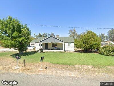
23142 Tehama Ave Gerber, CA 96035
Estimated Value: $193,115 - $392,000
3
Beds
1
Bath
1,418
Sq Ft
$198/Sq Ft
Est. Value
About This Home
This home is located at 23142 Tehama Ave, Gerber, CA 96035 and is currently estimated at $280,529, approximately $197 per square foot. 23142 Tehama Ave is a home located in Tehama County with nearby schools including Gerber Elementary School and Red Bluff High School.
Ownership History
Date
Name
Owned For
Owner Type
Purchase Details
Closed on
Mar 14, 2025
Sold by
Castillo Vazquez Cristi G
Bought by
El Camino Irrigation District
Current Estimated Value
Purchase Details
Closed on
Nov 24, 2023
Sold by
Castillo Vazquez Cristi G
Bought by
El Camino Irrigation District
Purchase Details
Closed on
Apr 30, 2020
Sold by
Katera Properties Llc
Bought by
Vazquez Cristi G Castillo
Home Financials for this Owner
Home Financials are based on the most recent Mortgage that was taken out on this home.
Original Mortgage
$95,000
Outstanding Balance
$85,098
Interest Rate
3.3%
Mortgage Type
Commercial
Estimated Equity
$195,431
Purchase Details
Closed on
Jun 8, 2017
Sold by
Pimentel Bertha E
Bought by
Katera Properties Llc
Create a Home Valuation Report for This Property
The Home Valuation Report is an in-depth analysis detailing your home's value as well as a comparison with similar homes in the area
Home Values in the Area
Average Home Value in this Area
Purchase History
| Date | Buyer | Sale Price | Title Company |
|---|---|---|---|
| El Camino Irrigation District | -- | -- | |
| El Camino Irrigation District | -- | -- | |
| Vazquez Cristi G Castillo | $135,000 | Orange Coast Ttl Co A Ca Cor | |
| Katera Properties Llc | $11,105 | None Available |
Source: Public Records
Mortgage History
| Date | Status | Borrower | Loan Amount |
|---|---|---|---|
| Open | Vazquez Cristi G Castillo | $95,000 |
Source: Public Records
Tax History Compared to Growth
Tax History
| Year | Tax Paid | Tax Assessment Tax Assessment Total Assessment is a certain percentage of the fair market value that is determined by local assessors to be the total taxable value of land and additions on the property. | Land | Improvement |
|---|---|---|---|---|
| 2023 | $1,483 | $141,907 | $42,046 | $99,861 |
| 2022 | $1,433 | $139,125 | $41,222 | $97,903 |
| 2021 | $1,408 | $136,398 | $40,414 | $95,984 |
| 2020 | $943 | $90,202 | $31,836 | $58,366 |
| 2019 | $939 | $88,434 | $31,212 | $57,222 |
| 2018 | $896 | $86,700 | $30,600 | $56,100 |
| 2017 | $891 | $90,837 | $12,410 | $78,427 |
| 2016 | $831 | $89,057 | $12,167 | $76,890 |
| 2015 | $817 | $87,721 | $11,985 | $75,736 |
| 2014 | $804 | $86,004 | $11,751 | $74,253 |
Source: Public Records
Map
Nearby Homes
- 8798 State Highway 99w
- 8202 State Highway 99w
- 23271 Olive Ave
- 7371 Mcclure Ave
- 7310 State Highway 99w
- 00 Mcclure Ave
- 22506 Dove Ave
- 22505 Dove Ave
- 23199 Reno Ave Unit EL CAMINO AREA
- 0 Reno Ave
- 0 Tehama Unit SN24169445
- 0 Tehama Unit 20240618
- 221 San Mateo Ave
- 24115 Black Bart Ct
- 501 San Benito Ave
- 505 San Benito Ave
- 216 1/2 Santa Maria Ave
- 9215 San Benito Ave
- 351 5th St
- 751 5th St