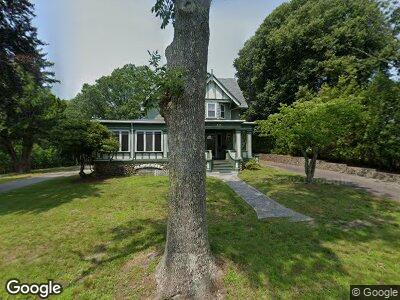
235 High St Somerset, MA 02726
Somerset Historic Village NeighborhoodEstimated Value: $631,000 - $918,000
4
Beds
3
Baths
3,873
Sq Ft
$194/Sq Ft
Est. Value
About This Home
This home is located at 235 High St, Somerset, MA 02726 and is currently estimated at $752,801, approximately $194 per square foot. 235 High St is a home located in Bristol County with nearby schools including North Elementary School, Somerset Middle School, and Swansea Wood School.
Ownership History
Date
Name
Owned For
Owner Type
Purchase Details
Closed on
Sep 23, 2016
Sold by
Souza Joseph E and Souza Cynthia J
Bought by
Souza Lt
Current Estimated Value
Purchase Details
Closed on
Aug 30, 1994
Sold by
Lecomte Paul M and Lecomte Dorothy G
Bought by
Souza Joseph E and Bergemann Cynthia J
Home Financials for this Owner
Home Financials are based on the most recent Mortgage that was taken out on this home.
Original Mortgage
$152,100
Interest Rate
8.65%
Mortgage Type
Purchase Money Mortgage
Create a Home Valuation Report for This Property
The Home Valuation Report is an in-depth analysis detailing your home's value as well as a comparison with similar homes in the area
Home Values in the Area
Average Home Value in this Area
Purchase History
| Date | Buyer | Sale Price | Title Company |
|---|---|---|---|
| Souza Lt | -- | -- | |
| Souza Joseph E | $169,000 | -- |
Source: Public Records
Mortgage History
| Date | Status | Borrower | Loan Amount |
|---|---|---|---|
| Previous Owner | Souza Joseph E | $137,500 | |
| Previous Owner | Souza Joseph E | $171,636 | |
| Previous Owner | Souza Joseph E | $152,100 |
Source: Public Records
Tax History Compared to Growth
Tax History
| Year | Tax Paid | Tax Assessment Tax Assessment Total Assessment is a certain percentage of the fair market value that is determined by local assessors to be the total taxable value of land and additions on the property. | Land | Improvement |
|---|---|---|---|---|
| 2025 | $10,951 | $823,400 | $191,400 | $632,000 |
| 2024 | $10,214 | $798,600 | $191,400 | $607,200 |
| 2023 | $9,012 | $710,700 | $166,700 | $544,000 |
| 2022 | $8,397 | $631,800 | $145,300 | $486,500 |
| 2021 | $8,498 | $578,900 | $132,200 | $446,700 |
| 2020 | $8,143 | $535,000 | $132,200 | $402,800 |
| 2019 | $9,056 | $496,200 | $132,200 | $364,000 |
| 2018 | $7,893 | $465,400 | $132,200 | $333,200 |
| 2017 | $7,705 | $442,800 | $126,200 | $316,600 |
| 2016 | $7,753 | $442,800 | $126,200 | $316,600 |
| 2015 | $7,247 | $417,700 | $120,600 | $297,100 |
| 2014 | $9,568 | $396,200 | $117,200 | $279,000 |
Source: Public Records
Map
Nearby Homes
- 0 Palmer St
- 562 Main St
- 665 Main St
- 138 Bourn Ave
- 345 Bourn Ave
- 2346 County St
- 1978 County St
- 1971 County St
- 112 Rounseville Ave
- 157 Chace St
- 5055 N Main St Unit 2
- 822 Regan Rd
- 75 Broad Cove St
- 15 Brisbon Rd
- 32 Pennsylvania Ave
- 259 Lynch Ave
- 4234 N Main St Unit 208
- 5455 N Main St Unit 12F
- 5455 N Main St Unit 6B
- 5455 N Main St Unit 7B