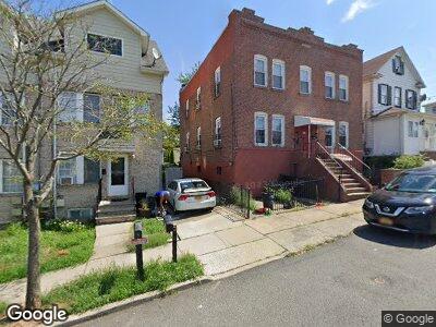
251 Livingston Ave Staten Island, NY 10314
Manor Heights NeighborhoodEstimated Value: $951,000 - $1,520,000
6
Beds
4
Baths
2,128
Sq Ft
$562/Sq Ft
Est. Value
About This Home
This home is located at 251 Livingston Ave, Staten Island, NY 10314 and is currently estimated at $1,196,333, approximately $562 per square foot. 251 Livingston Ave is a home located in Richmond County with nearby schools including P.S. 54 Charles W Leng, Is 72 Rocco Laurie, and Susan E Wagner High School.
Ownership History
Date
Name
Owned For
Owner Type
Purchase Details
Closed on
Feb 8, 2002
Sold by
Geevarghese Kochumman and Geevarghese Mariamma
Bought by
Thomas Shibu P and Thomas Sheeja P
Current Estimated Value
Home Financials for this Owner
Home Financials are based on the most recent Mortgage that was taken out on this home.
Original Mortgage
$296,370
Interest Rate
7.05%
Mortgage Type
Purchase Money Mortgage
Create a Home Valuation Report for This Property
The Home Valuation Report is an in-depth analysis detailing your home's value as well as a comparison with similar homes in the area
Home Values in the Area
Average Home Value in this Area
Purchase History
| Date | Buyer | Sale Price | Title Company |
|---|---|---|---|
| Thomas Shibu P | $329,500 | -- |
Source: Public Records
Mortgage History
| Date | Status | Borrower | Loan Amount |
|---|---|---|---|
| Open | Thomas Shibu P | $605,000 | |
| Closed | Thomas Shibu P | $150,000 | |
| Closed | Thomas Shibu P | $58,000 | |
| Closed | Thomas Shibu P | $17,948 | |
| Previous Owner | Thomas Shibu P | $296,370 |
Source: Public Records
Tax History Compared to Growth
Tax History
| Year | Tax Paid | Tax Assessment Tax Assessment Total Assessment is a certain percentage of the fair market value that is determined by local assessors to be the total taxable value of land and additions on the property. | Land | Improvement |
|---|---|---|---|---|
| 2024 | $6,993 | $50,700 | $6,098 | $44,602 |
| 2023 | $6,791 | $33,437 | $6,328 | $27,109 |
| 2022 | $6,508 | $41,400 | $8,880 | $32,520 |
| 2021 | $6,473 | $41,220 | $8,880 | $32,340 |
| 2020 | $6,891 | $44,940 | $8,880 | $36,060 |
| 2019 | $7,341 | $44,100 | $8,880 | $35,220 |
| 2018 | $5,680 | $27,864 | $6,749 | $21,115 |
| 2017 | $5,538 | $27,167 | $7,688 | $19,479 |
| 2016 | $5,124 | $25,630 | $6,973 | $18,657 |
| 2015 | $4,640 | $24,180 | $7,380 | $16,800 |
| 2014 | $4,640 | $24,180 | $7,380 | $16,800 |
Source: Public Records
Map
Nearby Homes
- 252 Livingston Ave Unit A
- 252A Livingston Ave
- 267 Graves St
- 235 Livingston Ave
- 184 Livingston Ave
- 431 Mountainview Ave
- 407 Mountainview Ave
- 476 Gower St
- 36 Oakville St
- 164 Queen St
- 61 Sunset Ave
- 173 Roosevelt Ave
- 125 Queen St
- 61 Oakville St
- 35 Duke Place
- 473 Fanning St
- 309 Brielle Ave
- 86 Sunset Ave
- 331 Mountainview Ave
- 147 Roosevelt Ave