

26527 (Nxt To) Old River Rd Monroe, OR 97456
Highlights
- Lake Front
- Mountain View
- Private Lot
- 350 Acre Lot
- Farm
- No HOA
About This Lot
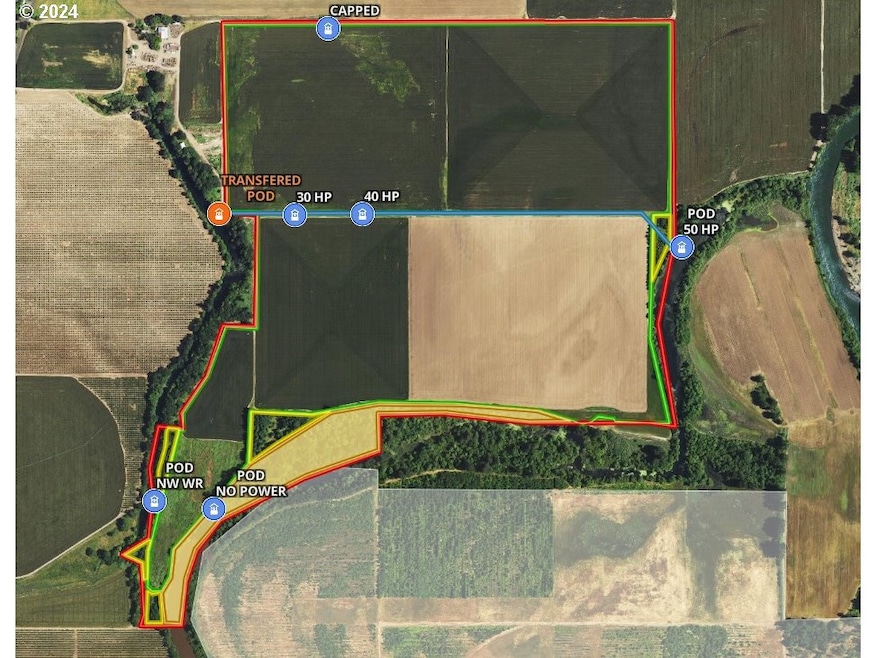
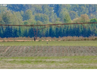
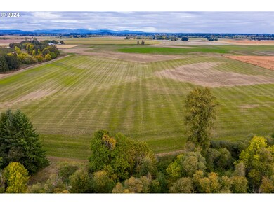
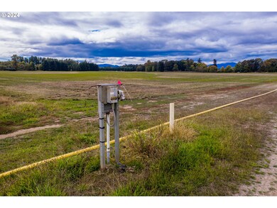
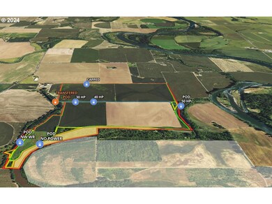
As of February 2025Rare large block of high value irrigated agricultural property in a region renowned for its productive farm ground. This square 350 +/- acre parcel features approximately 312 acres tillable supported predominately by Cloquato, Chehalis and with some Newberg/McBee silty clay loam soils. The complete water right coverage delivered w/ an underground main line make this land ideal for cultivating hazelnuts, blueberries, nursery stock and row crops. Static water level at 15 feet. Land only - no buildings.
Last Agent to Sell the Property
Keller Williams Realty Mid-Willamette License #960900133

Co-Listed By
STEVE HELMS - Oregon Farm Broke
Keller Williams Realty Mid-Willamette License #201210000
Property Details
Property Type
- Land
Est. Annual Taxes
- $5,285
Year Built
- 1878
Lot Details
- 350 Acre Lot
- Lake Front
- Dirt Road
- Private Lot
- Level Lot
- Landscaped with Trees
- Property is zoned EFU
Property Views
- Mountain
- Territorial
- Valley
Schools
- Monroe Elementary And Middle School
- Monroe High School
Farming
- Farm
Utilities
- 220 Volts
- Irrigation Well
- Irrigation Water Rights
- Well
Community Details
- No Home Owners Association
Listing and Financial Details
- Assessor Parcel Number 185730
Map
Home Values in the Area
Average Home Value in this Area
Property History
| Date | Event | Price | Change | Sq Ft Price |
|---|---|---|---|---|
| 02/14/2025 02/14/25 | Sold | $5,400,000 | -10.0% | -- |
| 11/19/2024 11/19/24 | Pending | -- | -- | -- |
| 11/01/2024 11/01/24 | For Sale | $6,000,000 | -- | -- |
Tax History
| Year | Tax Paid | Tax Assessment Tax Assessment Total Assessment is a certain percentage of the fair market value that is determined by local assessors to be the total taxable value of land and additions on the property. | Land | Improvement |
|---|---|---|---|---|
| 2024 | $5,450 | $432,481 | -- | -- |
| 2023 | $5,126 | $418,676 | $0 | $0 |
| 2022 | $5,009 | $408,007 | $0 | $0 |
| 2021 | $4,857 | $396,425 | $0 | $0 |
| 2020 | $193 | $15,610 | $0 | $0 |
| 2019 | $4,522 | $15,290 | $0 | $0 |
| 2018 | $4,917 | $363,617 | $0 | $0 |
| 2017 | $3,860 | $353,261 | $0 | $0 |
| 2016 | $3,700 | $341,026 | $0 | $0 |
Source: Regional Multiple Listing Service (RMLS)
MLS Number: 24661974
APN: 185730
Disclaimer: Certain information contained herein is derived from information provided by parties other than Homes.com. All information provided is deemed reliable, but is not guaranteed to be accurate and should be independently verified.
![]() The content relating to real estate for sale on this web site comes in part from the IDX program of the RMLS™ of Portland, Oregon. Real estate listings held by brokerage firms other than Ten-X are marked with the RMLS™ logo, and detailed information about these properties includes the names of the listing brokers. Listing content is copyright © 2025 RMLS™, Portland, Oregon. Some properties which appear for sale on this web site may subsequently have sold or may no longer be available. All information provided is deemed reliable but is not guaranteed and should be independently verified.
The content relating to real estate for sale on this web site comes in part from the IDX program of the RMLS™ of Portland, Oregon. Real estate listings held by brokerage firms other than Ten-X are marked with the RMLS™ logo, and detailed information about these properties includes the names of the listing brokers. Listing content is copyright © 2025 RMLS™, Portland, Oregon. Some properties which appear for sale on this web site may subsequently have sold or may no longer be available. All information provided is deemed reliable but is not guaranteed and should be independently verified.
- 27065 Highway 99 W
- 190 Oak St
- 194 Oak St
- 26740 Shady Oak Dr
- 694 Main St
- 780 Main St
- 24695 Territorial Hwy
- 26498 Coon Rd
- 25904 Alpine Rd
- 0 Coon Rd Unit 1 23175861
- 0 Hwy 99 W
- 23804 Highway 99 W
- 0 Crandall
- 25059 Larson Rd
- 26250 Holiday Ln
- 23900 Territorial Hwy
- 23900 Territorial Hwy Unit 2
- 23900 Territorial Hwy Unit 1
- 23900 Territorial Hwy Unit 3
- 27850 Hells Canyon Rd