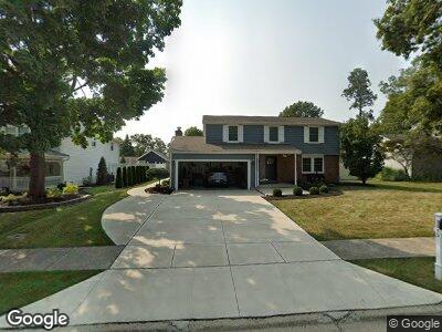
2813 Shadowood Dr Lima, OH 45805
Lakewood West NeighborhoodEstimated Value: $264,000 - $314,000
4
Beds
3
Baths
2,192
Sq Ft
$129/Sq Ft
Est. Value
About This Home
This home is located at 2813 Shadowood Dr, Lima, OH 45805 and is currently estimated at $281,867, approximately $128 per square foot. 2813 Shadowood Dr is a home located in Allen County with nearby schools including Elmwood Elementary School, Maplewood Elementary School, and Shawnee Middle School.
Ownership History
Date
Name
Owned For
Owner Type
Purchase Details
Closed on
May 24, 2007
Sold by
Lane Richard Todd
Bought by
Long Stacy E
Current Estimated Value
Purchase Details
Closed on
Sep 30, 2002
Sold by
Cooke Ralph F
Bought by
Lane Richard T
Purchase Details
Closed on
Sep 1, 1994
Sold by
Sullivan Paul
Bought by
Cooke Ralph and Cooke Jacqueline
Home Financials for this Owner
Home Financials are based on the most recent Mortgage that was taken out on this home.
Original Mortgage
$99,000
Interest Rate
8.59%
Mortgage Type
New Conventional
Purchase Details
Closed on
Dec 1, 1978
Bought by
Sullivan Paul J
Create a Home Valuation Report for This Property
The Home Valuation Report is an in-depth analysis detailing your home's value as well as a comparison with similar homes in the area
Home Values in the Area
Average Home Value in this Area
Purchase History
| Date | Buyer | Sale Price | Title Company |
|---|---|---|---|
| Long Stacy E | $100,000 | None Available | |
| Lane Richard T | $100,000 | -- | |
| Cooke Ralph | $110,000 | -- | |
| Sullivan Paul J | $69,500 | -- |
Source: Public Records
Mortgage History
| Date | Status | Borrower | Loan Amount |
|---|---|---|---|
| Open | Lane Stacy E | $138,500 | |
| Closed | Lane Richard Todd | $126,000 | |
| Closed | Lane Richard Todd | $30,000 | |
| Closed | Lane Richard Todd | $131,000 | |
| Closed | Lane Richard Todd | $131,500 | |
| Closed | Lane Richard Todd | $130,000 | |
| Previous Owner | Cooke Ralph | $99,000 |
Source: Public Records
Tax History Compared to Growth
Tax History
| Year | Tax Paid | Tax Assessment Tax Assessment Total Assessment is a certain percentage of the fair market value that is determined by local assessors to be the total taxable value of land and additions on the property. | Land | Improvement |
|---|---|---|---|---|
| 2024 | $2,716 | $67,830 | $9,030 | $58,800 |
| 2023 | $2,648 | $60,030 | $7,980 | $52,050 |
| 2022 | $2,671 | $60,030 | $7,980 | $52,050 |
| 2021 | $2,686 | $60,030 | $7,980 | $52,050 |
| 2020 | $2,358 | $56,070 | $7,560 | $48,510 |
| 2019 | $2,358 | $56,070 | $7,560 | $48,510 |
| 2018 | $2,349 | $56,070 | $7,560 | $48,510 |
| 2017 | $2,400 | $56,070 | $7,560 | $48,510 |
| 2016 | $2,376 | $56,070 | $7,560 | $48,510 |
| 2015 | $2,374 | $56,070 | $7,560 | $48,510 |
| 2014 | $2,258 | $52,680 | $7,810 | $44,870 |
| 2013 | $2,209 | $52,680 | $7,810 | $44,870 |
Source: Public Records
Map
Nearby Homes
- 2935 Hanover Dr
- 3059 Vera Way
- 250 Squire Ln
- 2432 Kunneke Ave
- 2253 Arcadia Ave
- XXXX Spencerville Rd
- 2225 Arcadia Ave
- 2254 Western Ohio Ave
- 1856 Wendell Ave
- 0 Springview Dr
- 2155 W Market St
- 159 Eagles Point S
- 128 S Westwood Dr
- 2109 Idlewild Dr
- 1408 Winghaven Dr
- 155 Eagles Point St S
- 204 Eagles Point East Point E
- 3390 Spencerville Rd
- 104 Eagles Point St W
- 2298 June Dr