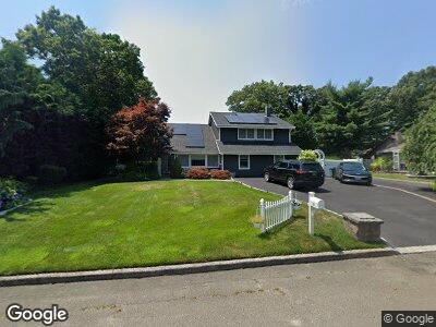
30 Fleetwood Dr Farmingville, NY 11738
Medford NeighborhoodEstimated Value: $742,643 - $779,000
5
Beds
4
Baths
2,573
Sq Ft
$296/Sq Ft
Est. Value
About This Home
This home is located at 30 Fleetwood Dr, Farmingville, NY 11738 and is currently estimated at $760,822, approximately $295 per square foot. 30 Fleetwood Dr is a home located in Suffolk County with nearby schools including Sagamore Middle School, Sachem High School East, and Long Island Baptist Academy.
Ownership History
Date
Name
Owned For
Owner Type
Purchase Details
Closed on
Mar 31, 2017
Sold by
Scoppettone Vincent
Bought by
Demario Michael and Demario Kristen
Current Estimated Value
Home Financials for this Owner
Home Financials are based on the most recent Mortgage that was taken out on this home.
Original Mortgage
$441,750
Interest Rate
4.1%
Mortgage Type
New Conventional
Purchase Details
Closed on
Nov 19, 2007
Sold by
Guzzi James
Bought by
Scoppettone Vincent
Purchase Details
Closed on
Sep 1, 2000
Sold by
Peck Theodore Vincent and Peck Christine H
Bought by
Guzzi James and Sammartino Guzzi Marie
Home Financials for this Owner
Home Financials are based on the most recent Mortgage that was taken out on this home.
Original Mortgage
$231,750
Interest Rate
8.07%
Create a Home Valuation Report for This Property
The Home Valuation Report is an in-depth analysis detailing your home's value as well as a comparison with similar homes in the area
Home Values in the Area
Average Home Value in this Area
Purchase History
| Date | Buyer | Sale Price | Title Company |
|---|---|---|---|
| Demario Michael | $472,000 | None Available | |
| Scoppettone Vincent | $505,000 | Marvin Penstein | |
| Guzzi James | $257,500 | -- |
Source: Public Records
Mortgage History
| Date | Status | Borrower | Loan Amount |
|---|---|---|---|
| Open | Demario Michael | $75,000 | |
| Open | Demario Michael | $431,150 | |
| Closed | Demario Michael | $18,054 | |
| Closed | Demario Michael | $441,750 | |
| Previous Owner | Guzzi James | $297,500 | |
| Previous Owner | Guzzi James | $231,750 |
Source: Public Records
Tax History Compared to Growth
Tax History
| Year | Tax Paid | Tax Assessment Tax Assessment Total Assessment is a certain percentage of the fair market value that is determined by local assessors to be the total taxable value of land and additions on the property. | Land | Improvement |
|---|---|---|---|---|
| 2023 | $13,805 | $3,675 | $300 | $3,375 |
| 2022 | $12,427 | $3,675 | $300 | $3,375 |
| 2021 | $12,427 | $3,675 | $300 | $3,375 |
| 2020 | $12,805 | $3,675 | $300 | $3,375 |
| 2019 | $12,805 | $0 | $0 | $0 |
| 2018 | $9,942 | $3,675 | $300 | $3,375 |
| 2017 | $9,942 | $3,325 | $300 | $3,025 |
| 2016 | $10,409 | $3,490 | $300 | $3,190 |
| 2015 | -- | $3,490 | $300 | $3,190 |
| 2014 | -- | $3,490 | $300 | $3,190 |
Source: Public Records
Map
Nearby Homes
- 114 Granny Rd
- 431 Adirondack Dr
- 232 Berkshire Dr
- 162 Berkshire Dr
- 55 Woodycrest Dr
- 114 W End Dr
- 756 Blue Ridge Dr
- 596 Blue Ridge Dr
- 766 Blue Ridge Dr
- 1 Rexmere Ave
- 26 Pineoaks Place
- 222 Birchwood Rd Unit 222
- 355 Birchwood Rd
- 556 Blue Ridge Dr
- 412 Birchwood Rd
- 20 John Dr
- 329 Birchwood Rd
- 327 Birchwood Rd
- 5523 Expressway Dr N
- 144 Golf Ln