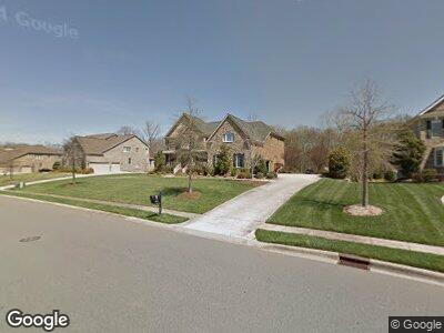
3004 Wheatfield Dr Waxhaw, NC 28173
Estimated Value: $1,687,000 - $1,868,000
5
Beds
7
Baths
6,646
Sq Ft
$264/Sq Ft
Est. Value
About This Home
This home is located at 3004 Wheatfield Dr, Waxhaw, NC 28173 and is currently estimated at $1,756,606, approximately $264 per square foot. 3004 Wheatfield Dr is a home located in Union County with nearby schools including Marvin Elementary School, Marvin Ridge Middle School, and Marvin Ridge High School.
Ownership History
Date
Name
Owned For
Owner Type
Purchase Details
Closed on
May 22, 2015
Sold by
Hamrick Pamela S and Hamrick John W
Bought by
Pampena Vincent J and Pampena Samantha
Current Estimated Value
Home Financials for this Owner
Home Financials are based on the most recent Mortgage that was taken out on this home.
Original Mortgage
$712,560
Outstanding Balance
$560,082
Interest Rate
3.77%
Mortgage Type
New Conventional
Estimated Equity
$1,196,524
Purchase Details
Closed on
Oct 26, 2005
Sold by
Nc Country Club Estates Lp
Bought by
Hamrick John W and Hamrick Pamela S
Home Financials for this Owner
Home Financials are based on the most recent Mortgage that was taken out on this home.
Original Mortgage
$178,250
Interest Rate
5.9%
Mortgage Type
Credit Line Revolving
Create a Home Valuation Report for This Property
The Home Valuation Report is an in-depth analysis detailing your home's value as well as a comparison with similar homes in the area
Home Values in the Area
Average Home Value in this Area
Purchase History
| Date | Buyer | Sale Price | Title Company |
|---|---|---|---|
| Pampena Vincent J | $891,000 | None Available | |
| Hamrick John W | $920,500 | Itic |
Source: Public Records
Mortgage History
| Date | Status | Borrower | Loan Amount |
|---|---|---|---|
| Open | Pampena Vincent J | $712,560 | |
| Previous Owner | Hamrick Pamela S | $77,000 | |
| Previous Owner | Hamrick Pamela S | $123,000 | |
| Previous Owner | Hamrick John W | $95,000 | |
| Previous Owner | Hamrick John W | $760,000 | |
| Previous Owner | Hamrick John W | $178,250 | |
| Previous Owner | Hamrick John W | $650,000 |
Source: Public Records
Tax History Compared to Growth
Tax History
| Year | Tax Paid | Tax Assessment Tax Assessment Total Assessment is a certain percentage of the fair market value that is determined by local assessors to be the total taxable value of land and additions on the property. | Land | Improvement |
|---|---|---|---|---|
| 2024 | $8,774 | $1,204,300 | $145,200 | $1,059,100 |
| 2023 | $8,505 | $1,204,300 | $145,200 | $1,059,100 |
| 2022 | $8,274 | $1,171,400 | $145,200 | $1,026,200 |
| 2021 | $8,075 | $1,171,400 | $145,200 | $1,026,200 |
| 2020 | $7,694 | $942,600 | $105,000 | $837,600 |
| 2019 | $7,694 | $942,600 | $105,000 | $837,600 |
| 2018 | $7,223 | $942,600 | $105,000 | $837,600 |
| 2017 | $8,109 | $942,600 | $105,000 | $837,600 |
| 2016 | $7,229 | $854,700 | $105,000 | $749,700 |
| 2015 | $6,692 | $854,700 | $105,000 | $749,700 |
| 2014 | $5,800 | $844,290 | $100,000 | $744,290 |
Source: Public Records
Map
Nearby Homes
- 3012 Wheatfield Dr
- 516 White Tail Terrace
- 9423 Belmont Ln
- 500 Clear Wood Ct
- 1108 Piper Meadows Dr Unit 52
- 1023 Piper Meadows Dr Unit 5
- 9217 Rock Water Ct
- LOT 1 Maxwell Ct
- LOT 2 Maxwell Ct
- 518 Streamside Ln
- 1057 Maxwell Ct Unit 13
- 1041 Maxwell Ct Unit 9
- 409 Running Horse Ln
- 101 Stonehurst Ln
- LOT 5 Maxwell Ct
- 1025 Maxwell Ct Unit 7
- LOT 14 Maxwell Ct
- 1048 Maxwell Ct Unit 17
- LOT 16 Maxwell Ct
- LOT 12 Maxwell Ct