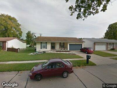
3046 Clanfield Dr Florissant, MO 63031
Estimated Value: $187,570 - $206,000
3
Beds
2
Baths
1,373
Sq Ft
$144/Sq Ft
Est. Value
About This Home
This home is located at 3046 Clanfield Dr, Florissant, MO 63031 and is currently estimated at $197,393, approximately $143 per square foot. 3046 Clanfield Dr is a home located in St. Louis County with nearby schools including Cold Water Elementary School, North Middle School, and Hazelwood Central High School.
Ownership History
Date
Name
Owned For
Owner Type
Purchase Details
Closed on
Dec 1, 2005
Sold by
Sommerville Anthony and Sommerville Marla
Bought by
Mortgage One Corp and Hfc Mortgage Corp
Current Estimated Value
Home Financials for this Owner
Home Financials are based on the most recent Mortgage that was taken out on this home.
Original Mortgage
$132,800
Interest Rate
6.19%
Mortgage Type
Fannie Mae Freddie Mac
Purchase Details
Closed on
Oct 27, 2005
Sold by
Mortgage One Corp
Bought by
Johnson Jacquette
Home Financials for this Owner
Home Financials are based on the most recent Mortgage that was taken out on this home.
Original Mortgage
$132,800
Interest Rate
6.19%
Mortgage Type
Fannie Mae Freddie Mac
Purchase Details
Closed on
Sep 15, 2000
Sold by
Wallace Michael S and Wallace Donna M
Bought by
Sommerville Anthony and Sommerville Marla
Home Financials for this Owner
Home Financials are based on the most recent Mortgage that was taken out on this home.
Original Mortgage
$122,787
Interest Rate
7.97%
Create a Home Valuation Report for This Property
The Home Valuation Report is an in-depth analysis detailing your home's value as well as a comparison with similar homes in the area
Home Values in the Area
Average Home Value in this Area
Purchase History
| Date | Buyer | Sale Price | Title Company |
|---|---|---|---|
| Mortgage One Corp | $121,486 | -- | |
| Johnson Jacquette | $137,900 | None Available | |
| Sommerville Anthony | $117,500 | -- |
Source: Public Records
Mortgage History
| Date | Status | Borrower | Loan Amount |
|---|---|---|---|
| Previous Owner | Johnson Jacquette | $132,800 | |
| Previous Owner | Sommerville Anthony | $122,787 |
Source: Public Records
Tax History Compared to Growth
Tax History
| Year | Tax Paid | Tax Assessment Tax Assessment Total Assessment is a certain percentage of the fair market value that is determined by local assessors to be the total taxable value of land and additions on the property. | Land | Improvement |
|---|---|---|---|---|
| 2023 | $2,825 | $32,390 | $2,830 | $29,560 |
| 2022 | $2,272 | $23,160 | $4,100 | $19,060 |
| 2021 | $2,239 | $23,160 | $4,100 | $19,060 |
| 2020 | $2,158 | $20,770 | $5,530 | $15,240 |
| 2019 | $2,125 | $20,770 | $5,530 | $15,240 |
| 2018 | $2,018 | $18,130 | $2,070 | $16,060 |
| 2017 | $2,016 | $18,130 | $2,070 | $16,060 |
| 2016 | $1,980 | $17,560 | $2,450 | $15,110 |
| 2015 | $1,937 | $17,560 | $2,450 | $15,110 |
| 2014 | $2,097 | $19,610 | $2,340 | $17,270 |
Source: Public Records
Map
Nearby Homes
- 1464 Monopoly Dr
- 1323 Kew Gardens Dr
- 1266 Borden Dr
- 1114 Ransome Ct
- 3322 Mowing Green Dr
- 2848 Dolfield Dr
- 3261 Sabrina Ln
- 2815 Hidden Spring Dr
- 1490 Burnside Ct
- 838 Liberty Village Dr
- 2797 Dawnview Dr
- 1258 Spartina Dr
- 1603 Norberg Dr
- 1812 Meadow Trails Dr
- 1825 Kilmory Dr
- 1323 Woodpath Dr
- 805 Sherwood Ct
- 969 Brookfield Chase Ct
- 926 Justice Ct
- 972 Brookfield Chase Ct