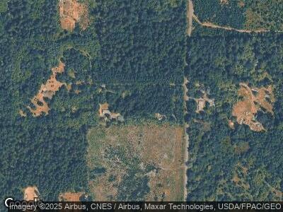
3282 E Harstine Island Rd S Shelton, WA 98584
Estimated Value: $73,000
--
Bed
--
Bath
--
Sq Ft
1.61
Acres
About This Home
This home is located at 3282 E Harstine Island Rd S, Shelton, WA 98584 and is currently estimated at $73,000. 3282 E Harstine Island Rd S is a home located in Mason County with nearby schools including Pioneer Primary School and Pioneer Intermediate/Middle School.
Ownership History
Date
Name
Owned For
Owner Type
Purchase Details
Closed on
Oct 9, 2024
Sold by
Good Land Resources Llc
Bought by
Hamilton Kevin L and Hamilton Victoria L
Current Estimated Value
Purchase Details
Closed on
Jan 30, 2024
Sold by
Keyes David A
Bought by
Good Land Resources Llc
Purchase Details
Closed on
Jun 22, 2007
Sold by
Rothrock Daniel
Bought by
Keyes David A and Nunez Sarita J
Home Financials for this Owner
Home Financials are based on the most recent Mortgage that was taken out on this home.
Original Mortgage
$28,000
Interest Rate
6.21%
Mortgage Type
New Conventional
Purchase Details
Closed on
Sep 12, 2005
Sold by
Penor Charlie P and Penor Helen C
Bought by
Rothrock Daniel
Create a Home Valuation Report for This Property
The Home Valuation Report is an in-depth analysis detailing your home's value as well as a comparison with similar homes in the area
Home Values in the Area
Average Home Value in this Area
Purchase History
| Date | Buyer | Sale Price | Title Company |
|---|---|---|---|
| Hamilton Kevin L | $45,000 | Land Title | |
| Good Land Resources Llc | $22,500 | Land Title | |
| Keyes David A | $35,000 | Land Title Co | |
| Rothrock Daniel | $18,900 | Land Title Co |
Source: Public Records
Mortgage History
| Date | Status | Borrower | Loan Amount |
|---|---|---|---|
| Previous Owner | Keyes David A | $28,000 |
Source: Public Records
Tax History Compared to Growth
Tax History
| Year | Tax Paid | Tax Assessment Tax Assessment Total Assessment is a certain percentage of the fair market value that is determined by local assessors to be the total taxable value of land and additions on the property. | Land | Improvement |
|---|---|---|---|---|
| 2025 | $343 | $52,725 | $52,725 | -- |
| 2023 | $343 | $31,705 | $31,705 | $0 |
| 2022 | $271 | $31,085 | $31,085 | $0 |
| 2021 | $293 | $31,085 | $31,085 | $0 |
| 2020 | $273 | $31,715 | $31,715 | $0 |
| 2018 | $181 | $26,065 | $26,065 | $0 |
| 2017 | $184 | $26,065 | $26,065 | $0 |
| 2016 | $181 | $19,400 | $19,400 | $0 |
| 2015 | $168 | $19,000 | $19,000 | $0 |
| 2014 | -- | $20,000 | $20,000 | $0 |
| 2013 | -- | $20,000 | $20,000 | $0 |
Source: Public Records
Map
Nearby Homes
- 3600 E Harstine Island Rd S
- 0 E E Camden Way
- 631 E Jared Rd
- 480 E Hedlund Dr
- 500 E Nicole Ln
- 201 E Smith Cove Way
- 110 E Smith Cove Way
- 41 E Leaf Ln
- 3234 Fishtrap Loop NE
- 2743 Fishtrap Loop NE
- 9247 Otis Beach St NE
- 8343 Willow Dr NE
- 2710 83rd Ct NE
- 9504 Maple Beach Ln NW
- 9829 Bowline Ct NW
- 2525 Island Dr NW
- 1948 Island Dr NW
- 2406 Island Dr NW
- 2525 Crestridge Dr NW
- 2202 Crestridge Dr NW
