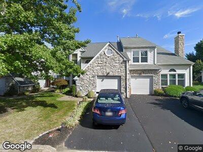
35 Walton Ct Newtown, PA 18940
Central Bucks County NeighborhoodEstimated Value: $549,000 - $575,000
3
Beds
3
Baths
2,253
Sq Ft
$249/Sq Ft
Est. Value
About This Home
This home is located at 35 Walton Ct, Newtown, PA 18940 and is currently estimated at $560,225, approximately $248 per square foot. 35 Walton Ct is a home located in Bucks County with nearby schools including Goodnoe Elementary School, Newtown Middle School, and Council Rock High School North.
Ownership History
Date
Name
Owned For
Owner Type
Purchase Details
Closed on
Aug 2, 2018
Sold by
Stoner Roy D and Stoner Marie T
Bought by
Stroner Roy D and Stroner Marie T
Current Estimated Value
Purchase Details
Closed on
Oct 24, 1994
Sold by
Marcoux Anne Marie
Bought by
Stoner Roy D and Stoner Marie
Home Financials for this Owner
Home Financials are based on the most recent Mortgage that was taken out on this home.
Original Mortgage
$105,000
Interest Rate
8.65%
Purchase Details
Closed on
Oct 16, 1991
Bought by
Marcoux Anne Marie
Create a Home Valuation Report for This Property
The Home Valuation Report is an in-depth analysis detailing your home's value as well as a comparison with similar homes in the area
Home Values in the Area
Average Home Value in this Area
Purchase History
| Date | Buyer | Sale Price | Title Company |
|---|---|---|---|
| Stroner Roy D | -- | None Available | |
| Stoner Roy D | $159,000 | -- | |
| Marcoux Anne Marie | $163,900 | -- |
Source: Public Records
Mortgage History
| Date | Status | Borrower | Loan Amount |
|---|---|---|---|
| Previous Owner | Stoner Roy D | $105,000 |
Source: Public Records
Tax History Compared to Growth
Tax History
| Year | Tax Paid | Tax Assessment Tax Assessment Total Assessment is a certain percentage of the fair market value that is determined by local assessors to be the total taxable value of land and additions on the property. | Land | Improvement |
|---|---|---|---|---|
| 2024 | $5,694 | $32,040 | $2,800 | $29,240 |
| 2023 | $5,448 | $32,040 | $2,800 | $29,240 |
| 2022 | $5,343 | $32,040 | $2,800 | $29,240 |
| 2021 | $5,260 | $32,040 | $2,800 | $29,240 |
| 2020 | $5,006 | $32,040 | $2,800 | $29,240 |
| 2019 | $4,888 | $32,040 | $2,800 | $29,240 |
| 2018 | $4,795 | $32,040 | $2,800 | $29,240 |
| 2017 | $4,629 | $32,040 | $2,800 | $29,240 |
| 2016 | $4,597 | $32,040 | $2,800 | $29,240 |
| 2015 | -- | $32,040 | $2,800 | $29,240 |
| 2014 | -- | $32,040 | $2,800 | $29,240 |
Source: Public Records
Map
Nearby Homes
- 577 Grant St
- 9 Caldwell Cir
- 16 Nathan Ct
- 202 Palmer Alley Unit 62
- 206 Paxon Alley Unit 51
- 135 Windham Ct
- 0 Route 413 Bypass Unit PABU2010042
- 10 Watson Mill Ln Unit 32
- 21 S Lincoln Ave Unit 10
- 3 Bennington Place
- 19 Bennington Place
- 48 Essex Place
- 110 N Lincoln Ave
- 17 Sterling St
- 15 Essex Place
- 52 David Dr
- 220 N Elm Ave
- 107 Mercer St
- 113 Thorton Ln
- 117 Thornton Ln