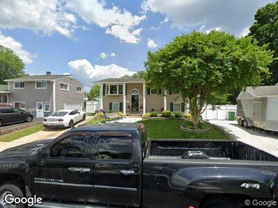
353 Walker St Aberdeen, MD 21001
Estimated Value: $315,000 - $336,372
--
Bed
1
Bath
1,293
Sq Ft
$250/Sq Ft
Est. Value
About This Home
This home is located at 353 Walker St, Aberdeen, MD 21001 and is currently estimated at $323,593, approximately $250 per square foot. 353 Walker St is a home located in Harford County with nearby schools including G. Lisby Elementary At Hillsdale, Aberdeen Middle School, and Aberdeen High School.
Ownership History
Date
Name
Owned For
Owner Type
Purchase Details
Closed on
Sep 10, 2003
Sold by
Secretary Of Housing
Bought by
Lane Donald M and Lane Misty D
Current Estimated Value
Purchase Details
Closed on
Dec 4, 2002
Sold by
Durbin Robert M
Bought by
Secretary Of Housing and Urban Development
Purchase Details
Closed on
Jun 28, 1996
Sold by
Wallace Ronald Van Buren
Bought by
Durbin Robert M and Durbin Felicia K
Create a Home Valuation Report for This Property
The Home Valuation Report is an in-depth analysis detailing your home's value as well as a comparison with similar homes in the area
Home Values in the Area
Average Home Value in this Area
Purchase History
| Date | Buyer | Sale Price | Title Company |
|---|---|---|---|
| Lane Donald M | $106,929 | -- | |
| Secretary Of Housing | $131,625 | -- | |
| Durbin Robert M | $96,500 | -- |
Source: Public Records
Mortgage History
| Date | Status | Borrower | Loan Amount |
|---|---|---|---|
| Open | Lane Donald M | $240,911 | |
| Closed | Lane Donald M | $246,489 | |
| Closed | Lane Donald M | $240,235 | |
| Closed | Lane Donald M | $250,705 | |
| Closed | Lane Donald M | $67,000 | |
| Closed | Lane Donald | $50,000 | |
| Closed | Lane Donald M | $36,763 | |
| Closed | Lane Donald M | $157,500 | |
| Closed | Durbin Robert M | -- |
Source: Public Records
Tax History Compared to Growth
Tax History
| Year | Tax Paid | Tax Assessment Tax Assessment Total Assessment is a certain percentage of the fair market value that is determined by local assessors to be the total taxable value of land and additions on the property. | Land | Improvement |
|---|---|---|---|---|
| 2024 | $2,448 | $256,767 | $0 | $0 |
| 2023 | $2,258 | $236,900 | $52,700 | $184,200 |
| 2022 | $2,138 | $224,233 | $0 | $0 |
| 2021 | $2,000 | $211,567 | $0 | $0 |
| 2020 | $2,000 | $198,900 | $52,700 | $146,200 |
| 2019 | $1,925 | $191,433 | $0 | $0 |
| 2018 | $1,834 | $183,967 | $0 | $0 |
| 2017 | $1,759 | $176,500 | $0 | $0 |
| 2016 | -- | $176,500 | $0 | $0 |
| 2015 | $2,140 | $176,500 | $0 | $0 |
| 2014 | $2,140 | $193,400 | $0 | $0 |
Source: Public Records
Map
Nearby Homes
- 648 S Rogers St
- 373 South Dr
- 127 Meeks Dr
- 426 Bonnett St
- 0 S Philadelphia Blvd
- 0 Harford St Unit MDHR2039982
- 511 Ohio Ct
- 214 S Parke St
- 45 Smith Ave
- 444 Chestnut St
- 70 Smith Ave
- 66 Norman Ave
- 110 Edmund St
- 74 Norman Ave
- 452 W Bel Air Ave
- 56 Aberdeen Ave
- 33A Swan St Unit A
- 18 N Law St
- 29 Mount Royal Ave
- 58 Krouse Ct