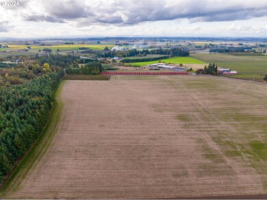
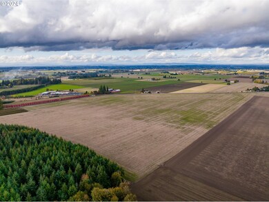
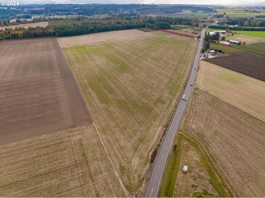
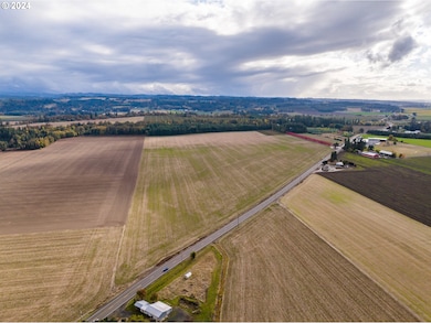
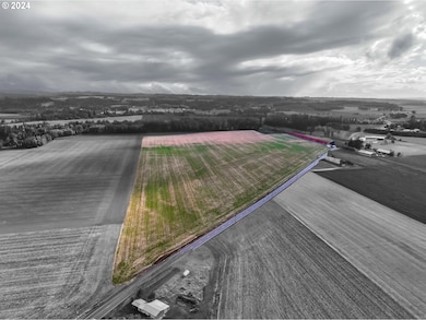
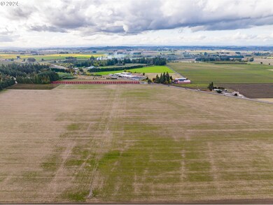
$2,100,000

37486 S Hwy 213 (Adj To) Mount Angel, OR 97362

Estimated payment $11,804/month

Total Views 8,865
80 Acres
$26,283 Price per Acre
3,480,444 Sq Ft Lot

Highlights

  • Access To Creek
  • 79.9 Acre Lot
  • No HOA
  • View of Trees or Woods
  • Farm
  • 80 Irrigated Acres

About This Lot

A total of 80 acres featuring high-quality and fertile Amity Silt Loam soils is available. The property includes groundwater and surface water rights established in 1983, with surface water sourced from Butte Creek. It is equipped with tiling and drainage systems. This land is ideally suited for cultivating high-value crops such as hazelnuts, hops, fruit trees, or nursery plants. Its visibility along Highway 213 presents excellent opportunities for any business-to-business or business-to-consumer agricultural enterprise. There is also the potential to qualify for a dwelling unit, allowing you to establish a home base on the property. Take advantage of this opportunity to acquire a segment of Oregon's agricultural potential.

Listing Agent

Mark Shadrin

Berkshire Hathaway HomeServices Real Estate Professionals License #201215479

Berkshire Hathaway HomeServices Real Estate Professionals

Property Details

Property Type

  • Land

Est. Annual Taxes

  • $993

Lot Details

  • 79.9 Acre Lot
  • Level Lot
  • Property is zoned EFU

Property Views

  • Woods
  • Mountain
  • Territorial

Schools

  • Butte Creek Elementary School
  • Silverton Middle School
  • Silverton High School

Farming

  • Farm
  • 80 Irrigated Acres

Utilities

  • Irrigation Water Rights

Listing and Financial Details

  • Assessor Parcel Number 01126356

Community Details

Overview

  • No Home Owners Association

Recreation

  • Access To Creek

Property Details

Property Type

Land

Est. Annual Taxes

$993

Lot Details

0

Listing Details

  • Standard Status: Active
  • MLS Status: Active
  • Property Type: Land
  • Property Sub Type: Farm
  • Property Attached Yn: No
  • Open House: No
  • PublicRemarksFarm: 80 acres of prime and productive Amity Silt Loam soils. Ground water rights and surface water rights dating back to 1983. Surface water supplied by Butte Creek. Property is tiled/ drained. Highway 213 exposure.
  • PublicRemarksWaterRights: Ground water rights and surface water rights dating back to 1983. Surface water supplied by Butte Creek.
  • Special Features: None

Interior Features

  • Lot Size Range: Acres50to100

Exterior Features

  • Farm Type: Farm
  • Lot Size: 50 to 99.99 Acres
  • View: Yes
  • Road Frontage: Yes
  • Lot Features: PublicRoad
  • Road Surface Type: Paved
  • View: Mountain,Territorial,TreesWoods

Garage/Parking

  • Attached Garage: No

Utilities

  • Utilities: SeeRemarks, WaterAvailable
  • Cooling Y N: No
  • Heating Yn: No

Condo/Co-op/Association

  • Association: No

Schools

  • Elementary School: Butte Creek
  • High School: Silverton
  • Middle Or Junior School: Silverton

Lot Info

  • Water Rights Acres Irrigated: 80.00
  • Water Rights Current: Yes
  • Water Rights Date Priority: 1983-01-01
  • Water Rights Type: GroundWater,SurfaceWater
  • Water Rights Use: Agriculture,Irrigation
  • Zoning: EFU
  • Present Use: Agricultural, Farm, RawLand
  • Additional Parcels: No
  • Soil Type Classification: Amity Silt Loam
  • Land Description: Level
  • Land Lease: No
  • Lot Size Acres: 79.9
  • Lot Size Sq Ft: 3480444.0
  • Cultivated Acreage: 78.0
  • Wooded Area: 2.0
  • Parcel #: 01126356
  • Irrigation Water Rights Acres: 80.0
  • Irrigation Water Rights: Yes

Green Features

  • Green Certification: No

Rental Info

  • Availability: Sale

Tax Info

  • Tax Deferral: No
  • Tax Year: 2023
  • Tax Annual Amount: 993.32

Map

Range of Values:

Collateral Analytics

Collateral Analytics Collateral Analytics AVMs (Automated Valuation Model) employ a number of statistical approaches combined with neighborhood-specific comparable selection guarantees the most up-to-date and precise valuations.

Not Available

Collateral Analytics does not have data for the current month. Please view the chart for historical values.

ICE

ICE Mortgage Technology ICE Mortgage Technology’s AVM (Automated Valuation Model) is a state-of-the-art online residential property valuation tool that provides a quick and accurate estimate of the value of almost any home in the U.S.

Not Available

ICE Mortgage Technology does not have data for the current month. Please view the chart for historical values.

First American

First American First American Data & Analytics’ next-generation AVM combines unrivaled data assets with a blended ensemble of valuation models to produce highly accurate, reliable valuations you can trust.

Not Available

First American does not have data for the current month. Please view the chart for historical values.

Quantarium

Quantarium Quantarium’s valuation service, repeatedly proven the industry’s most accurate and comprehensive, is supercharged with a self-learning and auto-tuning AI engine that continually becomes smarter and more accurate as it processes daily inputs from the industry’s leading RE data lake.

Not Available

Quantarium does not have data for the current month. Please view the chart for historical values.

Average Value
Not Available
List Price
Sold Price
Create a Home Valuation Report for This Property
The Home Valuation Report is an in-depth analysis detailing your home's value as well as a comparison with similar homes in the area

Home Values in the Area

Source: Public Records

Average Home Value in this Area


Source: Public Records

Tax History

Year Tax Paid Tax Assessment Tax Assessment Total Assessment is a certain percentage of the fair market value that is determined by local assessors to be the total taxable value of land and additions on the property. Land Improvement
2023 $1,018 $75,708 $0 $0
2022 $970 $73,561 $0 $0
2021 $931 $71,486 $0 $0
2020 $910 $69,411 $0 $0
2019 $882 $67,410 $0 $0
2018 $861 $65,482 $0 $0
2017 $842 $63,554 $0 $0
2016 $817 $61,779 $0 $0
2015 $793 $59,999 $0 $0
2014 $773 $58,296 $0 $0
Source: Public Records

Property History

Date Event Price Change Sq Ft Price
10/23/2024 10/23/24 For Sale $2,100,000 -- --
Source: Regional Multiple Listing Service (RMLS)

Deed History

Date Type Sale Price Title Company
Warranty Deed $650,000 Multiple
Bargain Sale Deed -- Transnation Title Insurance
Source: Public Records

Similar Property in Mount Angel, OR

  • 37486 S Highway 213 (Adj To), Mount Angel, OR 97362

    $2,100,000

    • Land
    • 80 Acres
    • $26,283 per Acre
    • 37486 S Highway 213 (Adj To)
    • Mount Angel, OR

    80 acres of prime and productive Amity Silt Loam soils. Ground water rights and surface water rights dating back to 1983. Surface water supplied by Butte Creek. Property is tiled/ drained. This property is perfect for high value crops from hazelnuts, hops, fruit trees, or nursery. Highway 213 exposure is great for any B2B or B2C agricultural related venture. Potential to qualify for a dwelling

    Mark Shadrin BERKSHIRE HATHAWAY HOMESERVICES R E PROF

    Section Image

Source: Regional Multiple Listing Service (RMLS)

MLS Number: 24640904

Regional Multiple Listing Service (RMLS)

APN: 01126356