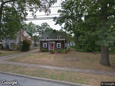
382 Wallace St Freeport, NY 11520
Estimated Value: $480,036 - $561,000
--
Bed
--
Bath
1,330
Sq Ft
$391/Sq Ft
Est. Value
About This Home
This home is located at 382 Wallace St, Freeport, NY 11520 and is currently estimated at $520,518, approximately $391 per square foot. 382 Wallace St is a home located in Nassau County with nearby schools including Roosevelt Middle School, Roosevelt High School, and Roosevelt Children's Academy.
Ownership History
Date
Name
Owned For
Owner Type
Purchase Details
Closed on
Oct 25, 2006
Sold by
Dumisani Kambi-Shamba
Current Estimated Value
Purchase Details
Closed on
Sep 17, 2002
Sold by
Lister Donald
Bought by
Kambi-Shamba Dumisani
Purchase Details
Closed on
Jan 26, 1996
Sold by
Baldwin Arthur and Baldwin Elizabeth
Bought by
Kambi-Shamba Dumisani and Kambi-Shamba Bernadette
Home Financials for this Owner
Home Financials are based on the most recent Mortgage that was taken out on this home.
Original Mortgage
$121,380
Interest Rate
7.91%
Mortgage Type
VA
Create a Home Valuation Report for This Property
The Home Valuation Report is an in-depth analysis detailing your home's value as well as a comparison with similar homes in the area
Home Values in the Area
Average Home Value in this Area
Purchase History
| Date | Buyer | Sale Price | Title Company |
|---|---|---|---|
| -- | -- | -- | |
| Kambi-Shamba Dumisani | $2,500 | -- | |
| Kambi-Shamba Dumisani | $119,000 | -- |
Source: Public Records
Mortgage History
| Date | Status | Borrower | Loan Amount |
|---|---|---|---|
| Previous Owner | Kambi-Shamba Dumisani | $121,380 |
Source: Public Records
Tax History Compared to Growth
Tax History
| Year | Tax Paid | Tax Assessment Tax Assessment Total Assessment is a certain percentage of the fair market value that is determined by local assessors to be the total taxable value of land and additions on the property. | Land | Improvement |
|---|---|---|---|---|
| 2024 | $521 | $339 | $125 | $214 |
| 2023 | $4,733 | $286 | $125 | $161 |
| 2022 | $4,733 | $286 | $125 | $161 |
| 2021 | $7,311 | $270 | $118 | $152 |
| 2020 | $6,679 | $614 | $389 | $225 |
| 2019 | $7,081 | $614 | $389 | $225 |
| 2018 | $6,879 | $614 | $0 | $0 |
| 2017 | $5,655 | $614 | $389 | $225 |
| 2016 | $6,388 | $614 | $389 | $225 |
| 2015 | $694 | $614 | $389 | $225 |
| 2014 | $694 | $614 | $389 | $225 |
| 2013 | $660 | $614 | $389 | $225 |
Source: Public Records
Map
Nearby Homes
- 4 Oxford Dr
- 83 Evans Ave
- 44 Mount Joy Ave
- 180 Moore Ave
- 182 Evans Ave
- 82 Royal Dr
- 108 Maple Dr
- 20 Woodside Ave
- 246 N Long Beach Ave
- 121 Hudson Ave
- 174 Delaware Ave
- 19 Independence Ave
- 255 Moore Ave
- 53 Forest Ave
- 121 W Seaman Ave
- 72 Woodside Ave
- 263 Pennsylvania Ave
- 245 Pennsylvania Ave
- 216 N Ocean Ave
- 168 W Fulton Ave