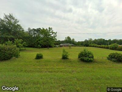
40480 State Highway 59 Bay Minette, AL 36507
Estimated Value: $219,000 - $270,000
4
Beds
2
Baths
1,377
Sq Ft
$172/Sq Ft
Est. Value
About This Home
This home is located at 40480 State Highway 59, Bay Minette, AL 36507 and is currently estimated at $236,582, approximately $171 per square foot. 40480 State Highway 59 is a home located in Baldwin County with nearby schools including Pine Grove Elementary School, Bay Minette Middle School, and Baldwin County High School.
Ownership History
Date
Name
Owned For
Owner Type
Purchase Details
Closed on
Oct 26, 2022
Sold by
White Janice S
Bought by
S & S Investments Llc
Current Estimated Value
Home Financials for this Owner
Home Financials are based on the most recent Mortgage that was taken out on this home.
Original Mortgage
$161,500
Outstanding Balance
$157,268
Interest Rate
6.92%
Mortgage Type
Credit Line Revolving
Estimated Equity
$79,314
Purchase Details
Closed on
Dec 18, 2008
Sold by
White Donald
Bought by
White Janice S
Purchase Details
Closed on
Nov 21, 2008
Sold by
White Donald
Bought by
White Janice S
Purchase Details
Closed on
Oct 11, 2008
Sold by
Thompson Christie
Bought by
White Janice S
Create a Home Valuation Report for This Property
The Home Valuation Report is an in-depth analysis detailing your home's value as well as a comparison with similar homes in the area
Home Values in the Area
Average Home Value in this Area
Purchase History
| Date | Buyer | Sale Price | Title Company |
|---|---|---|---|
| S & S Investments Llc | $190,000 | -- | |
| White Janice S | -- | None Available | |
| White Janice S | -- | None Available | |
| White Janice S | -- | None Available | |
| White Janice S | -- | None Available | |
| White Janice S | -- | None Available |
Source: Public Records
Mortgage History
| Date | Status | Borrower | Loan Amount |
|---|---|---|---|
| Open | S & S Investments Llc | $161,500 | |
| Previous Owner | White Janice S | $105,000 | |
| Previous Owner | White Janice S | $96,202 | |
| Previous Owner | White Janice | $108,000 | |
| Previous Owner | White Janice | $87,000 |
Source: Public Records
Tax History Compared to Growth
Tax History
| Year | Tax Paid | Tax Assessment Tax Assessment Total Assessment is a certain percentage of the fair market value that is determined by local assessors to be the total taxable value of land and additions on the property. | Land | Improvement |
|---|---|---|---|---|
| 2024 | $1,297 | $43,220 | $8,860 | $34,360 |
| 2023 | $1,229 | $38,120 | $10,480 | $27,640 |
| 2022 | $1,048 | $34,940 | $0 | $0 |
| 2021 | $0 | $32,000 | $0 | $0 |
| 2020 | $430 | $14,320 | $0 | $0 |
| 2019 | $761 | $25,380 | $0 | $0 |
| 2018 | $710 | $23,660 | $0 | $0 |
| 2017 | $658 | $21,920 | $0 | $0 |
| 2016 | $618 | $20,600 | $0 | $0 |
| 2015 | -- | $21,120 | $0 | $0 |
| 2014 | -- | $20,360 | $0 | $0 |
| 2013 | -- | $20,360 | $0 | $0 |
Source: Public Records
Map
Nearby Homes
- 0 Quinley Ln
- 39449 State Highway 59 S
- 51655 Highway 59 Unit 34-B
- 00 U S Highway 31
- 41500 Whitehouse Fork Rd
- 38211 V R Byrd Rd
- 0 Dogwood Fork Rd Unit 7347527
- 0 Dogwood Fork Rd Unit 358700
- 16549 Pine Grove Road Extension N
- 101 Stover Dr
- 39908 T A Chastang Rd
- Parcel C Pine Grove Rd
- Parcel B Pine Grove Rd
- 43156 Pine Grove Rd
- 0 State Highway 59 Unit 371168
- 0 State Highway 59 Unit 7239248
- 11528 Whitehouse Fork Road Extension
- 1307 Shedrick Hardy Pkwy
- 1108 Pecan St
- 0 Whitehouse Fork Rd Unit 11254126
