
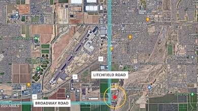


4175 S Litchfield Rd Avondale, AZ 85323
Estrella Village NeighborhoodEstimated payment $69,625/month
About This Lot
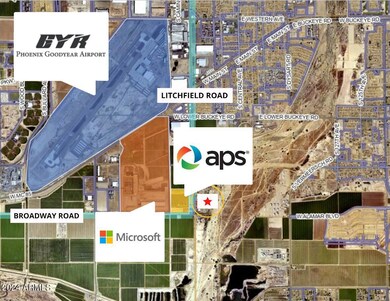
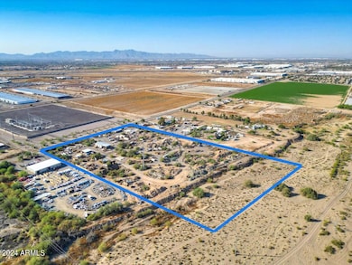
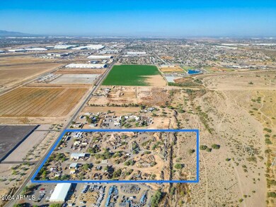
Here is a fantastic opportunity to own land in an up-and-coming high value area! Neighboring property owners include Microsoft, Amazon, an APS substation and multiple data centers under construction. An additional bonus is being within 1 mile of Phoenix-Goodyear Airport and the planned State Route 30 which will tie the Loop 303 to the Loop 202 together. Listing consists of 5 parcels: 500-59-004-A / 500-59-012-A / 500-59-003 / 500-59-012-B / 500-59-004-B for a total of 18.56 acres. The land is currently zoned AG (agriculture) but can easily be re-zoned industrial. There is private easement access from Lz2 Ranch Road off Litchfield Road. All existing equipment and personal property will be removed prior to COE. Reach out to the listing broker for additional details.

Property Details
Property Type
- Land
Est. Annual Taxes
- $8,325
Year Built
- 1989
Lot Details
- 18.56 Acre Lot
- Chain Link Fence
- Additional Parcels
- Property is zoned AG
Community Details
- No Home Owners Association
Listing and Financial Details
- Assessor Parcel Number 500-59-012-B
Map
Home Values in the Area
Average Home Value in this Area
Tax History
| Year | Tax Paid | Tax Assessment Tax Assessment Total Assessment is a certain percentage of the fair market value that is determined by local assessors to be the total taxable value of land and additions on the property. | Land | Improvement |
|---|---|---|---|---|
| 2025 | $2,688 | $24,930 | -- | -- |
| 2024 | $2,745 | $24,485 | -- | -- |
| 2023 | $2,745 | $66,113 | $47,498 | $18,615 |
| 2022 | $2,722 | $52,973 | $34,930 | $18,043 |
| 2021 | $2,954 | $53,388 | $34,758 | $18,630 |
| 2020 | $2,862 | $31,896 | $13,032 | $18,864 |
| 2019 | $2,845 | $31,986 | $12,762 | $19,224 |
| 2018 | $2,856 | $25,758 | $6,750 | $19,008 |
| 2017 | $2,786 | $22,266 | $5,472 | $16,794 |
| 2016 | $2,841 | $21,636 | $6,372 | $15,264 |
| 2015 | $2,715 | $18,519 | $6,161 | $12,358 |
Property History
| Date | Event | Price | Change | Sq Ft Price |
|---|---|---|---|---|
| 07/23/2024 07/23/24 | For Sale | $12,350,000 | -- | -- |
Deed History
| Date | Type | Sale Price | Title Company |
|---|---|---|---|
| Special Warranty Deed | $611,914 | None Available |
Source: Arizona Regional Multiple Listing Service (ARMLS)
MLS Number: 6734896
APN: 500-59-012B
Disclaimer: Certain information contained herein is derived from information provided by parties other than Homes.com. All information provided is deemed reliable, but is not guaranteed to be accurate and should be independently verified.
![]() All information should be verified by the recipient and none is guaranteed as accurate by ARMLS
All information should be verified by the recipient and none is guaranteed as accurate by ARMLS
Listing Information presented by local MLS brokerage: Ten-X, local REALTOR®- Arlene Richardson - (888)-952-6393
- 0 Lower Buckeye -- Unit 12
- 4310 S Bullard Ave
- 4310 S Bullard Ave
- 300 W Lower Buckeye Rd Unit 12
- 300 W Lower Buckeye Rd Unit 26
- 300 W Lower Buckeye Rd Unit 42
- 406 W Mountain View Dr
- 618 E Elm Ln
- 12708 W Corona Ave
- 12722 W Luxton Ln
- 12725 W Luxton Ln
- 12712 W Corona Ave
- 12721 W Corona Ave
- 728 S 3rd St
- 4424 S 127th Ave
- 12630 W Parkway Ln
- 12628 W Illini St
- 12580 W Trumbull Rd
- 12631 W Parkway Ln
- 12569 W Trumbull Rd