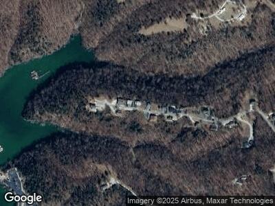
428 Dockview Rd Monticello, KY 42633
Estimated Value: $207,723 - $301,000
3
Beds
2
Baths
--
Sq Ft
0.46
Acres
About This Home
This home is located at 428 Dockview Rd, Monticello, KY 42633 and is currently estimated at $241,931. 428 Dockview Rd is a home located in Wayne County with nearby schools including Walker Early Learning Center, Monticello Elementary School, and Bell Elementary School.
Ownership History
Date
Name
Owned For
Owner Type
Purchase Details
Closed on
Jan 7, 2022
Sold by
Michael A Holtgrefe A and Michael Constance S
Bought by
Dockview Llc
Current Estimated Value
Home Financials for this Owner
Home Financials are based on the most recent Mortgage that was taken out on this home.
Original Mortgage
$72,000
Outstanding Balance
$67,522
Interest Rate
3.05%
Mortgage Type
Credit Line Revolving
Estimated Equity
$173,508
Purchase Details
Closed on
Dec 9, 2009
Sold by
Hatfield Vannie and Hatfield Earl
Bought by
Holtgrefe Michael A and Holtgrefe Constance S
Home Financials for this Owner
Home Financials are based on the most recent Mortgage that was taken out on this home.
Original Mortgage
$100,000
Interest Rate
5.01%
Mortgage Type
Future Advance Clause Open End Mortgage
Purchase Details
Closed on
Jan 7, 2006
Sold by
Meadors Inc
Bought by
Hatfield Vannie
Create a Home Valuation Report for This Property
The Home Valuation Report is an in-depth analysis detailing your home's value as well as a comparison with similar homes in the area
Home Values in the Area
Average Home Value in this Area
Purchase History
| Date | Buyer | Sale Price | Title Company |
|---|---|---|---|
| Dockview Llc | $172,000 | Prominent Title | |
| Dockview Llc | $172,000 | Prominent Title Agency | |
| Holtgrefe Michael A | $14,000 | Chase Legal Title Llc | |
| Hatfield Vannie | $16,250 | None Available |
Source: Public Records
Mortgage History
| Date | Status | Borrower | Loan Amount |
|---|---|---|---|
| Open | Dockview Llc | $72,000 | |
| Closed | Dockview Llc | $72,000 | |
| Previous Owner | Holtgrefe Michael A | $100,000 |
Source: Public Records
Tax History Compared to Growth
Tax History
| Year | Tax Paid | Tax Assessment Tax Assessment Total Assessment is a certain percentage of the fair market value that is determined by local assessors to be the total taxable value of land and additions on the property. | Land | Improvement |
|---|---|---|---|---|
| 2024 | $1,552 | $172,000 | $0 | $0 |
| 2023 | $1,624 | $172,000 | $0 | $0 |
| 2022 | $1,333 | $140,000 | $20,000 | $120,000 |
| 2021 | $1,343 | $140,000 | $20,000 | $120,000 |
| 2020 | $1,358 | $140,000 | $20,000 | $120,000 |
| 2019 | $1,359 | $140,000 | $20,000 | $120,000 |
| 2018 | $1,355 | $140,000 | $20,000 | $120,000 |
| 2017 | $1,364 | $140,000 | $0 | $0 |
| 2016 | $1,291 | $140,000 | $20,000 | $120,000 |
| 2015 | $1,270 | $140,000 | $20,000 | $120,000 |
| 2012 | $1,207 | $140,000 | $20,000 | $120,000 |
Source: Public Records
Map
Nearby Homes
- 641 Webster Spradlin Rd
- 613 Webster Spradlin Rd
- 114 Blevins Ridge Rd
- Lots 18-21 Harmony Ln
- 500 Beaver Lodge Rd
- 4-7 Cart Bell Ridge Rd
- 567 Cart Bell Ridge Rd
- 23-25 Bart's Way
- 371 Dug Rd
- 9999 Cr-1479
- 45.72 Acre Hwy 674
- 401 Old Bethel Rd
- 116 Waters Edge Trail
- Lot 133 Sandstone Trail
- Lot 128 Sandstone Point Trail
- Lot 68 Sandstone Point Trail
- 000 Sandstone Point Trail
- Lot 35 Sandstone Point Trail
- Lot 76 Sandstone Point Trail
- Lot 74 Sandstone Point Trail
