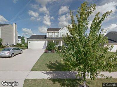
4298 Aylesford Rd Uniontown, OH 44685
Estimated Value: $417,000 - $473,000
4
Beds
3
Baths
2,786
Sq Ft
$160/Sq Ft
Est. Value
About This Home
This home is located at 4298 Aylesford Rd, Uniontown, OH 44685 and is currently estimated at $444,839, approximately $159 per square foot. 4298 Aylesford Rd is a home located in Summit County with nearby schools including Greenwood Elementary School, Green Intermediate Elementary School, and Green Primary School.
Ownership History
Date
Name
Owned For
Owner Type
Purchase Details
Closed on
Sep 17, 2003
Sold by
Nvr Inc
Bought by
Morris Brian D and Morris Shelley R
Current Estimated Value
Home Financials for this Owner
Home Financials are based on the most recent Mortgage that was taken out on this home.
Original Mortgage
$185,145
Interest Rate
6.49%
Mortgage Type
Purchase Money Mortgage
Purchase Details
Closed on
Jul 16, 2003
Sold by
Union Square Investments Ltd
Bought by
Nvr Inc and Ryan Homes
Create a Home Valuation Report for This Property
The Home Valuation Report is an in-depth analysis detailing your home's value as well as a comparison with similar homes in the area
Home Values in the Area
Average Home Value in this Area
Purchase History
| Date | Buyer | Sale Price | Title Company |
|---|---|---|---|
| Morris Brian D | $248,865 | Nvr Title Agency Llc | |
| Nvr Inc | $45,000 | Cornerstone Real Estate Titl |
Source: Public Records
Mortgage History
| Date | Status | Borrower | Loan Amount |
|---|---|---|---|
| Open | Morris Brian D | $105,400 | |
| Closed | Morris Brian D | $110,000 | |
| Closed | Morris Brian D | $166,100 | |
| Closed | Morris Brian D | $185,500 | |
| Closed | Morris Brian D | $185,145 |
Source: Public Records
Tax History Compared to Growth
Tax History
| Year | Tax Paid | Tax Assessment Tax Assessment Total Assessment is a certain percentage of the fair market value that is determined by local assessors to be the total taxable value of land and additions on the property. | Land | Improvement |
|---|---|---|---|---|
| 2025 | $5,948 | $125,024 | $21,266 | $103,758 |
| 2024 | $5,948 | $125,024 | $21,266 | $103,758 |
| 2023 | $5,948 | $125,024 | $21,266 | $103,758 |
| 2022 | $4,818 | $90,791 | $15,411 | $75,380 |
| 2021 | $4,523 | $90,791 | $15,411 | $75,380 |
| 2020 | $4,435 | $90,790 | $15,410 | $75,380 |
| 2019 | $4,545 | $87,220 | $15,260 | $71,960 |
| 2018 | $4,645 | $87,220 | $15,260 | $71,960 |
| 2017 | $4,446 | $87,220 | $15,260 | $71,960 |
| 2016 | $4,423 | $78,280 | $15,260 | $63,020 |
| 2015 | $4,446 | $78,280 | $15,260 | $63,020 |
| 2014 | $4,415 | $78,280 | $15,260 | $63,020 |
| 2013 | $4,515 | $79,670 | $15,260 | $64,410 |
Source: Public Records
Map
Nearby Homes
- 4313 Evergreen Ct Unit 66
- 4309 Evergreen Ct Unit 65
- 4328 Evergreen Ct Unit 52
- 1999 Hemlock Ct
- 2271 Graybill Rd
- 3303 Graybill Rd
- 1984 Stake Dr
- 2335 Greensburg Rd
- 4301 Evergreen Ct Unit 63
- 4324 Evergreen Ct Unit 53
- 4317 Evergreen Ct Unit 67
- 4305 Evergreen Ct Unit 64
- 2144 Prestwick Dr
- 0 Massillon Rd
- 2146 Greensburg Rd
- 2785 Wise Rd
- 2136 Beechtree Dr
- 3632 Kenwood Dr
- 2029 Carlile Dr
- 2033 Carlile Dr