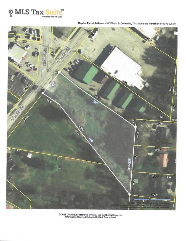
434 W Main St Cookeville, TN 38506
Estimated payment $1,066/month
Highlights
- Home fronts a creek
- No HOA
- Level Lot
- Algood Elementary School Rated A-
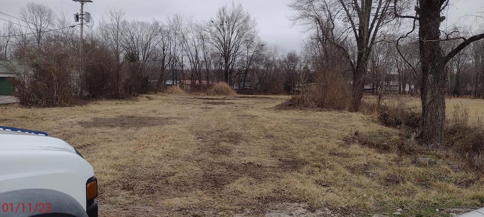
About This Lot
1.1 acres, level and cleared, general commercial (C-A) zoning, tons of possibilities, Algood city limits, easy access to Hwy 111.
Property Details
Property Type
- Land
Est. Annual Taxes
- $737
Year Built
- 1948
Lot Details
- 1.1 Acre Lot
- Home fronts a creek
- Level Lot
- Property is zoned Gen Comm
Community Details
- No Home Owners Association
Listing and Financial Details
- Assessor Parcel Number 006.00
Map
Home Values in the Area
Average Home Value in this Area
Tax History
| Year | Tax Paid | Tax Assessment Tax Assessment Total Assessment is a certain percentage of the fair market value that is determined by local assessors to be the total taxable value of land and additions on the property. | Land | Improvement |
|---|---|---|---|---|
| 2024 | $692 | $26,000 | $26,000 | $0 |
| 2023 | $692 | $26,000 | $26,000 | $0 |
| 2022 | $643 | $26,000 | $26,000 | $0 |
| 2021 | $737 | $26,000 | $26,000 | $0 |
| 2020 | $585 | $26,000 | $26,000 | $0 |
| 2019 | $673 | $20,000 | $20,000 | $0 |
| 2018 | $1,087 | $33,760 | $20,000 | $13,760 |
| 2017 | $1,087 | $33,760 | $20,000 | $13,760 |
| 2016 | $1,095 | $33,760 | $20,000 | $13,760 |
| 2015 | $1,120 | $33,760 | $20,000 | $13,760 |
| 2014 | $623 | $18,778 | $0 | $0 |
Property History
| Date | Event | Price | Change | Sq Ft Price |
|---|---|---|---|---|
| 11/05/2024 11/05/24 | For Sale | $180,000 | 0.0% | -- |
| 01/31/2023 01/31/23 | Pending | -- | -- | -- |
| 01/31/2023 01/31/23 | For Sale | $180,000 | +33.3% | -- |
| 01/25/2023 01/25/23 | Sold | $135,000 | -22.9% | -- |
| 01/23/2023 01/23/23 | Pending | -- | -- | -- |
| 12/27/2022 12/27/22 | Price Changed | $175,000 | -50.0% | -- |
| 01/27/2022 01/27/22 | For Sale | $350,000 | +159.3% | -- |
| 01/01/1970 01/01/70 | Off Market | $135,000 | -- | -- |
Deed History
| Date | Type | Sale Price | Title Company |
|---|---|---|---|
| Warranty Deed | $135,000 | -- | |
| Deed | $40,000 | -- |
Mortgage History
| Date | Status | Loan Amount | Loan Type |
|---|---|---|---|
| Previous Owner | $80,000 | New Conventional | |
| Previous Owner | $32,000 | No Value Available |
Source: Upper Cumberland Association of REALTORS®
MLS Number: 217109
APN: 041C-G-006.00
Disclaimer: Certain information contained herein is derived from information provided by parties other than Homes.com. All information provided is deemed reliable, but is not guaranteed to be accurate and should be independently verified.
![]() Copyright 2025 Upper Cumberland Board of Realtors. All rights reserved. Information deemed to be reliable but not guaranteed. The data relating to real estate for sale on this website comes from Upper Cumberland Board of Realtors.
Copyright 2025 Upper Cumberland Board of Realtors. All rights reserved. Information deemed to be reliable but not guaranteed. The data relating to real estate for sale on this website comes from Upper Cumberland Board of Realtors.
Some or all of the listings displayed may not belong to the firm whose website is being visited.
- 301 Dry Valley Rd
- 292 Williams Cir
- 251 Haven Ln
- 301 Williams Cir
- 164 W Wall St
- 360 Emily Ct
- 0 Virginia St
- 372 Brookside Dr
- 159 2nd Ave S
- 2070 Burton Branch Rd
- 1611 Bobby Nichols Dr
- 210 2nd Ave N
- 175 McCawley St
- 1604 Bobby Nichols Dr
- 0 Middleford Dr Unit 235801
- 2289 Nicholas Ave
- 1881 Mickelson Ct
- 1648 Bobby Nichols Dr
- 2297 Lopez Ct
- 2298 Nicholas Ave
